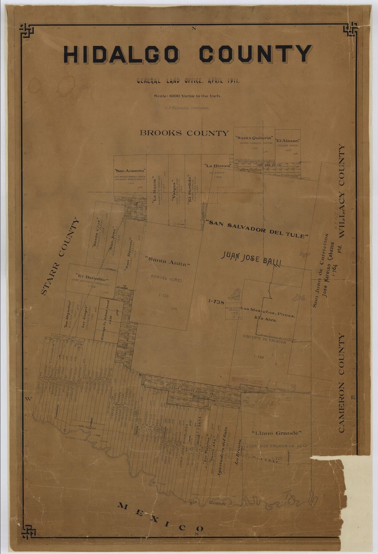
Hidalgo County
-
Map/Doc
16850
-
Collection
General Map Collection
-
Object Dates
1911 (Creation Date)
-
People and Organizations
Texas General Land Office (Publisher)
H.F. McDonald (Draftsman)
H.F. McDonald (Compiler)
-
Counties
Hidalgo
-
Subjects
County
-
Height x Width
42.1 x 28.7 inches
106.9 x 72.9 cm
-
Comments
Conservation funded in 2002 with donation from the Republic Royalty Company.
-
Features
Pharr
Hidalgo
Rio Grande
Savage
Run
Progreso
Mercedes
STLB&M
Donna
Edinburg
San Juan
Candelaria Hill
Macallen [sic]
Mission
Reynosa Vieja
Abram
Closner
Samfordyce [sic]
Alto Verde
Salt Lake
Sal de Rey
Part of: General Map Collection
Flight Mission No. BRA-16M, Frame 69, Jefferson County

Print $20.00
- Digital $50.00
Flight Mission No. BRA-16M, Frame 69, Jefferson County
1953
Size 18.6 x 22.2 inches
Map/Doc 85686
Map from the Sabine River to the Rio Grande as subdivided for mineral development

Print $20.00
- Digital $50.00
Map from the Sabine River to the Rio Grande as subdivided for mineral development
Size 30.6 x 44.8 inches
Map/Doc 65801
Wood County Rolled Sketch 10

Print $20.00
- Digital $50.00
Wood County Rolled Sketch 10
Size 30.1 x 26.1 inches
Map/Doc 76416

Hutchinson County Rolled Sketch 43

Print $40.00
- Digital $50.00
Hutchinson County Rolled Sketch 43
1992
Size 40.6 x 49.9 inches
Map/Doc 6315
Flight Mission No. DAG-18K, Frame 68, Matagorda County

Print $20.00
- Digital $50.00
Flight Mission No. DAG-18K, Frame 68, Matagorda County
1952
Size 16.4 x 16.3 inches
Map/Doc 86361

Cooke County Working Sketch 16

Print $20.00
- Digital $50.00
Cooke County Working Sketch 16
1949
Size 29.8 x 28.9 inches
Map/Doc 68253
Zavala County Working Sketch 30

Print $20.00
- Digital $50.00
Zavala County Working Sketch 30
1989
Size 36.8 x 28.1 inches
Map/Doc 62105
Clay County Working Sketch 4

Print $20.00
- Digital $50.00
Clay County Working Sketch 4
1923
Size 14.7 x 21.9 inches
Map/Doc 68027
Galveston County Rolled Sketch RB

Print $20.00
- Digital $50.00
Galveston County Rolled Sketch RB
Size 36.0 x 22.2 inches
Map/Doc 5990
Sterling County Sketch File 10

Print $30.00
- Digital $50.00
Sterling County Sketch File 10
1927
Size 11.2 x 8.7 inches
Map/Doc 37133
You may also like
Flight Mission No. BQR-4K, Frame 70, Brazoria County

Print $20.00
- Digital $50.00
Flight Mission No. BQR-4K, Frame 70, Brazoria County
1952
Size 18.8 x 22.4 inches
Map/Doc 84003
Intracoastal Waterway - Galveston Bay to West Bay including Galveston Bay Entrance

Print $20.00
- Digital $50.00
Intracoastal Waterway - Galveston Bay to West Bay including Galveston Bay Entrance
1962
Size 26.9 x 38.6 inches
Map/Doc 69936
Montague County Working Sketch 38

Print $20.00
- Digital $50.00
Montague County Working Sketch 38
1990
Size 14.9 x 15.6 inches
Map/Doc 71104
Crane County Sketch File 30

Print $40.00
- Digital $50.00
Crane County Sketch File 30
1933
Size 14.0 x 8.4 inches
Map/Doc 19610
Medina County Working Sketch 14

Print $20.00
- Digital $50.00
Medina County Working Sketch 14
1972
Size 21.5 x 30.7 inches
Map/Doc 70929
Flight Mission No. CGI-4N, Frame 177, Cameron County

Print $20.00
- Digital $50.00
Flight Mission No. CGI-4N, Frame 177, Cameron County
1955
Size 18.5 x 22.2 inches
Map/Doc 84680

Mexico Comision Pesquisidora de la Frontera del Norte

Mexico Comision Pesquisidora de la Frontera del Norte
1874
Map/Doc 97125
Webb County Working Sketch 66

Print $40.00
- Digital $50.00
Webb County Working Sketch 66
1966
Size 62.8 x 42.5 inches
Map/Doc 72433
Callahan County Rolled Sketch 3

Print $20.00
- Digital $50.00
Callahan County Rolled Sketch 3
1948
Size 36.1 x 35.3 inches
Map/Doc 8561
Henderson County Rolled Sketch 11

Print $20.00
- Digital $50.00
Henderson County Rolled Sketch 11
1915
Size 29.3 x 42.6 inches
Map/Doc 75952
La Salle County Sketch File 23

Print $40.00
- Digital $50.00
La Salle County Sketch File 23
Size 14.2 x 17.3 inches
Map/Doc 29530