Padre Island
Sketch Showing Parts of Sections 10 and 12 and all of Section 11 of J. S. Boyles' Survey made in 1941
-
Map/Doc
2272
-
Collection
General Map Collection
-
Object Dates
1976 (Creation Date)
-
People and Organizations
Abner G. Trigg (Surveyor/Engineer)
-
Height x Width
251.0 x 30.0 inches
637.5 x 76.2 cm
-
Scale
1" = 500 feet
Part of: General Map Collection
North Part of Brewster Co.

Print $20.00
- Digital $50.00
North Part of Brewster Co.
1956
Size 40.0 x 37.9 inches
Map/Doc 77220
Edwards County Working Sketch 43

Print $20.00
- Digital $50.00
Edwards County Working Sketch 43
1950
Size 20.3 x 27.7 inches
Map/Doc 68919
Calhoun County Rolled Sketch 29C

Print $20.00
- Digital $50.00
Calhoun County Rolled Sketch 29C
1977
Size 22.0 x 24.0 inches
Map/Doc 8559
Trinity River, Dallas Elevation Sheet

Print $20.00
- Digital $50.00
Trinity River, Dallas Elevation Sheet
1913
Size 26.6 x 24.1 inches
Map/Doc 65258
Pecos County Rolled Sketch 22

Print $20.00
- Digital $50.00
Pecos County Rolled Sketch 22
1886
Size 22.4 x 36.8 inches
Map/Doc 93454
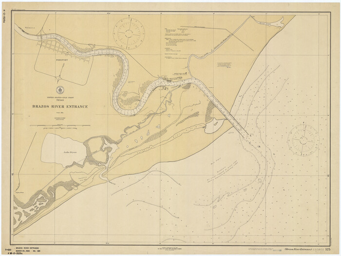
Brazos River Entrance
Print $20.00
- Digital $50.00
Brazos River Entrance
1925
Size 31.0 x 41.4 inches
Map/Doc 69974
Falls County Working Sketch 2

Print $20.00
- Digital $50.00
Falls County Working Sketch 2
1922
Size 19.0 x 30.0 inches
Map/Doc 69177
Flight Mission No. BRA-6M, Frame 82, Jefferson County

Print $20.00
- Digital $50.00
Flight Mission No. BRA-6M, Frame 82, Jefferson County
1953
Size 18.5 x 22.3 inches
Map/Doc 85426
Angelina County Working Sketch 55

Print $20.00
- Digital $50.00
Angelina County Working Sketch 55
1989
Size 33.7 x 30.0 inches
Map/Doc 67139
[The S.K. Ry. of Texas, State Line to Pecos, Reeves Co., Texas]
![64163, [The S.K. Ry. of Texas, State Line to Pecos, Reeves Co., Texas], General Map Collection](https://historictexasmaps.com/wmedia_w700/maps/64163.tif.jpg)
Print $40.00
- Digital $50.00
[The S.K. Ry. of Texas, State Line to Pecos, Reeves Co., Texas]
1910
Size 19.3 x 120.2 inches
Map/Doc 64163
Motley County Sketch File 5 (S)

Print $20.00
- Digital $50.00
Motley County Sketch File 5 (S)
Size 20.5 x 19.4 inches
Map/Doc 42138
Outer Continental Shelf Leasing Maps (Texas Offshore Operations)

Print $20.00
- Digital $50.00
Outer Continental Shelf Leasing Maps (Texas Offshore Operations)
Size 20.7 x 15.1 inches
Map/Doc 75848
You may also like
Flight Mission No. BRA-8M, Frame 80, Jefferson County

Print $20.00
- Digital $50.00
Flight Mission No. BRA-8M, Frame 80, Jefferson County
1953
Size 15.9 x 15.6 inches
Map/Doc 85600
George M. Slaughter Block Hockley and Cochran Counties, Texas

Print $20.00
- Digital $50.00
George M. Slaughter Block Hockley and Cochran Counties, Texas
1929
Size 14.1 x 25.2 inches
Map/Doc 92238
Galveston County Working Sketch 5

Print $20.00
- Digital $50.00
Galveston County Working Sketch 5
1934
Size 41.2 x 41.0 inches
Map/Doc 69342

Aransas County Working Sketch Graphic Index

Print $20.00
- Digital $50.00
Aransas County Working Sketch Graphic Index
1947
Size 36.8 x 36.6 inches
Map/Doc 76455
Sabine County Working Sketch Graphic Index

Print $20.00
- Digital $50.00
Sabine County Working Sketch Graphic Index
1920
Size 42.4 x 33.1 inches
Map/Doc 76689
Childress County Rolled Sketch 18

Print $20.00
- Digital $50.00
Childress County Rolled Sketch 18
1913
Size 17.6 x 39.0 inches
Map/Doc 5451
Block D14 Terry County

Print $20.00
- Digital $50.00
Block D14 Terry County
Size 17.0 x 17.7 inches
Map/Doc 92416
[Block Y2 and Part of Block 1, B. & B.]
![91169, [Block Y2 and Part of Block 1, B. & B.], Twichell Survey Records](https://historictexasmaps.com/wmedia_w700/maps/91169-1.tif.jpg)
Print $20.00
- Digital $50.00
[Block Y2 and Part of Block 1, B. & B.]
Size 26.2 x 17.6 inches
Map/Doc 91169
Kendall County Sketch File 16

Print $4.00
- Digital $50.00
Kendall County Sketch File 16
1877
Size 8.7 x 5.9 inches
Map/Doc 28705
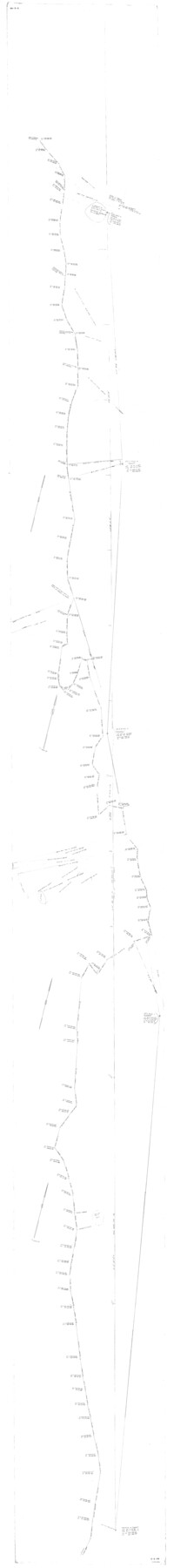
Right of Way and Track Map International & Gt. Northern Ry. operated by the International & Gt. Northern Ry. Co., Columbia Branch, Gulf Division

Print $40.00
- Digital $50.00
Right of Way and Track Map International & Gt. Northern Ry. operated by the International & Gt. Northern Ry. Co., Columbia Branch, Gulf Division
1917
Size 25.1 x 56.4 inches
Map/Doc 64596
Childress County Rolled Sketch 5

Print $20.00
- Digital $50.00
Childress County Rolled Sketch 5
1913
Size 31.2 x 24.7 inches
Map/Doc 5439