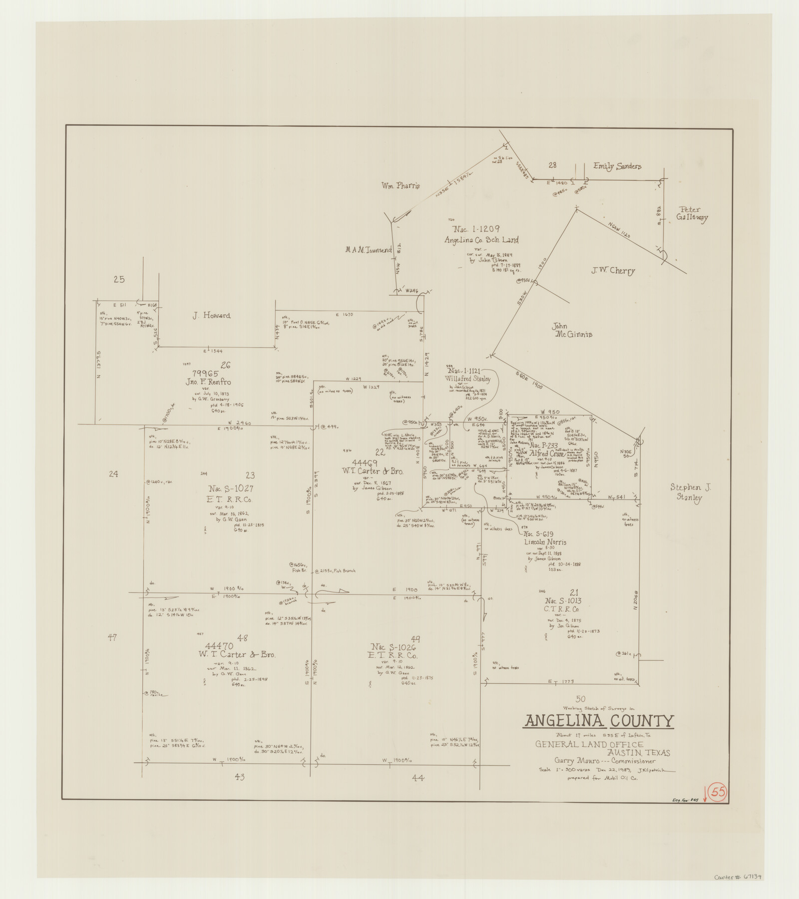
Angelina County Working Sketch 55
-
Map/Doc
67139
-
Collection
General Map Collection
-
Object Dates
12/22/1989 (Creation Date)
-
People and Organizations
Joan Kilpatrick (Draftsman)
Garry Mauro (GLO Commissioner)
-
Counties
Angelina
-
Subjects
Surveying Working Sketch
-
Height x Width
33.7 x 30.0 inches
85.6 x 76.2 cm
-
Scale
1" = 300 varas
-
Comments
Surveys located about 17 miles South 35 degrees East from Lufkin, Texas.
Part of: General Map Collection
Edwards County Boundary File 27d

Print $10.00
- Digital $50.00
Edwards County Boundary File 27d
Size 12.8 x 8.5 inches
Map/Doc 52901

Coryell County Working Sketch 18

Print $20.00
- Digital $50.00
Coryell County Working Sketch 18
1965
Size 24.6 x 34.3 inches
Map/Doc 68225
Duval County Sketch File 38

Print $64.00
- Digital $50.00
Duval County Sketch File 38
Size 38.2 x 19.5 inches
Map/Doc 10372
Flight Mission No. DQN-6K, Frame 74, Calhoun County

Print $20.00
- Digital $50.00
Flight Mission No. DQN-6K, Frame 74, Calhoun County
1953
Size 18.5 x 22.2 inches
Map/Doc 84446
Hardin County Sketch File 53

Print $12.00
- Digital $50.00
Hardin County Sketch File 53
Size 11.4 x 8.8 inches
Map/Doc 25213
Montague County Boundary File 2a

Print $8.00
- Digital $50.00
Montague County Boundary File 2a
Size 13.0 x 8.3 inches
Map/Doc 57410
Cooke County Working Sketch 35

Print $20.00
- Digital $50.00
Cooke County Working Sketch 35
1974
Size 30.7 x 32.6 inches
Map/Doc 68272
Presidio County Rolled Sketch 53

Print $20.00
- Digital $50.00
Presidio County Rolled Sketch 53
1911
Size 13.0 x 22.2 inches
Map/Doc 7346

United States - Gulf Coast - Galveston to Rio Grande

Print $20.00
- Digital $50.00
United States - Gulf Coast - Galveston to Rio Grande
1941
Size 27.2 x 18.2 inches
Map/Doc 72753
Wilbarger County Rolled Sketch 8

Print $20.00
- Digital $50.00
Wilbarger County Rolled Sketch 8
1965
Size 22.0 x 18.9 inches
Map/Doc 8257
You may also like
Flight Mission No. BRE-3P, Frame 34, Nueces County

Print $20.00
- Digital $50.00
Flight Mission No. BRE-3P, Frame 34, Nueces County
1956
Size 18.5 x 22.3 inches
Map/Doc 86812
Calhoun County Rolled Sketch 12

Print $40.00
- Digital $50.00
Calhoun County Rolled Sketch 12
1940
Size 30.2 x 54.8 inches
Map/Doc 43619
Flight Mission No. DAG-28K, Frame 26, Matagorda County

Print $20.00
- Digital $50.00
Flight Mission No. DAG-28K, Frame 26, Matagorda County
1953
Size 18.5 x 22.3 inches
Map/Doc 86594
United States - Gulf Coast Texas - Southern part of Laguna Madre

Print $20.00
- Digital $50.00
United States - Gulf Coast Texas - Southern part of Laguna Madre
1941
Size 26.5 x 18.3 inches
Map/Doc 72955
Flight Mission No. CLL-3N, Frame 45, Willacy County

Print $20.00
- Digital $50.00
Flight Mission No. CLL-3N, Frame 45, Willacy County
1954
Size 18.4 x 22.1 inches
Map/Doc 87103
Flight Mission No. DQN-5K, Frame 73, Calhoun County

Print $20.00
- Digital $50.00
Flight Mission No. DQN-5K, Frame 73, Calhoun County
1953
Size 18.4 x 22.0 inches
Map/Doc 84406
Victoria County Sketch File 13

Print $10.00
- Digital $50.00
Victoria County Sketch File 13
2001
Size 11.5 x 8.8 inches
Map/Doc 39542
Sterling County Boundary File 1

Print $56.00
- Digital $50.00
Sterling County Boundary File 1
Size 9.0 x 8.7 inches
Map/Doc 58919
Right of Way & Track Map San Antonio & Aransas Pass Railway Co.

Print $40.00
- Digital $50.00
Right of Way & Track Map San Antonio & Aransas Pass Railway Co.
1919
Size 24.8 x 55.8 inches
Map/Doc 64038
Pecos County Rolled Sketch 103

Print $20.00
- Digital $50.00
Pecos County Rolled Sketch 103
1940
Size 27.5 x 32.4 inches
Map/Doc 7251
Upton County Rolled Sketch 54

Print $20.00
- Digital $50.00
Upton County Rolled Sketch 54
Size 23.5 x 35.6 inches
Map/Doc 8089
Fisher County Rolled Sketch 4A

Print $20.00
- Digital $50.00
Fisher County Rolled Sketch 4A
1951
Size 31.0 x 36.6 inches
Map/Doc 8889