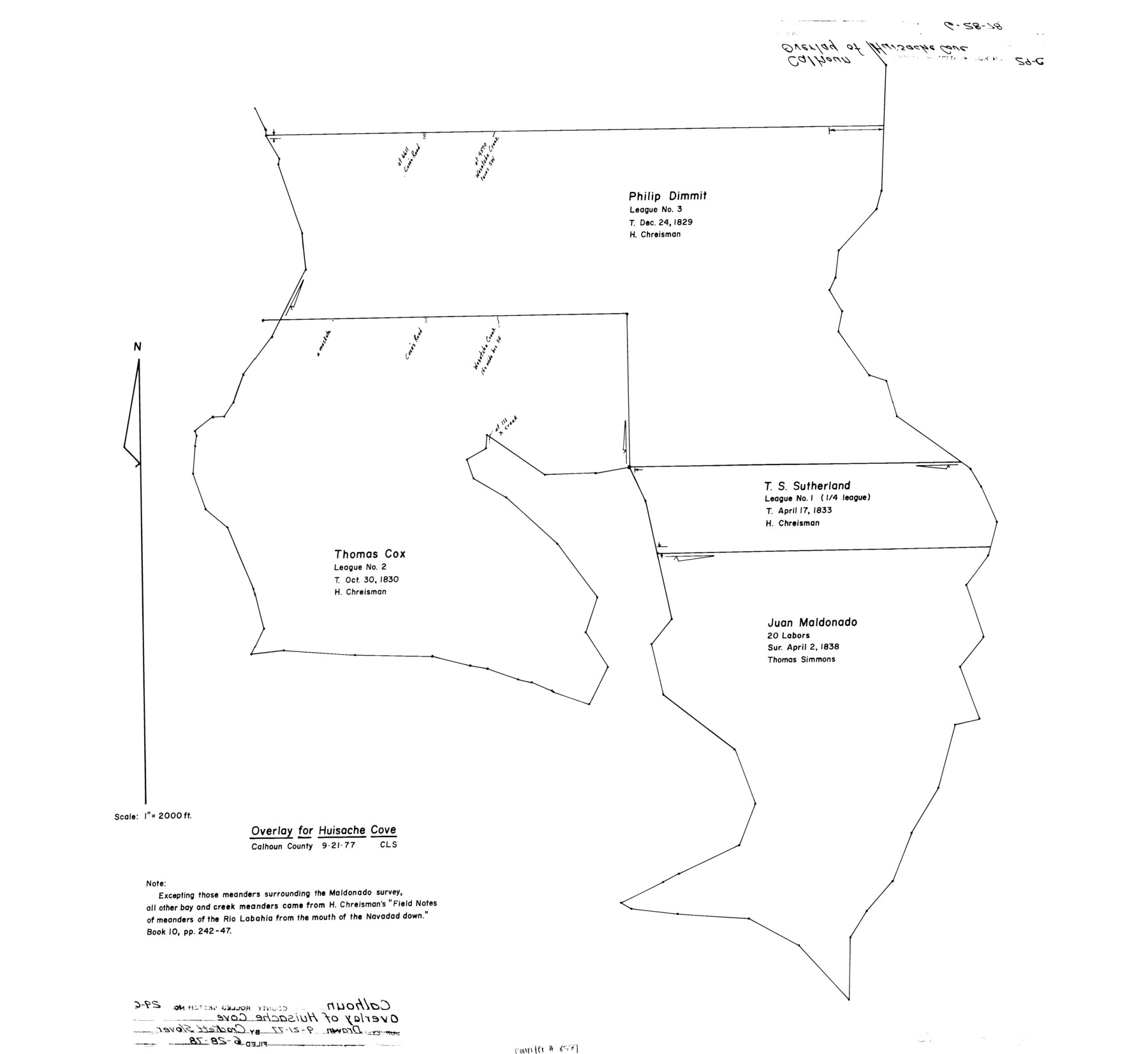
Calhoun County Rolled Sketch 29C
Overlay for Huisache Cove
-
Map/Doc
8559
-
Collection
General Map Collection
-
Object Dates
1977/9/21 (Creation Date)
1978/6/28 (File Date)
-
People and Organizations
Crockett Slover (Draftsman)
-
Counties
Calhoun
-
Subjects
Surveying Rolled Sketch
-
Height x Width
22.0 x 24.0 inches
55.9 x 61.0 cm
-
Scale
1" = 2000 feet
-
Comments
See Calhoun County Rolled Sketch 29A (8557) and Calhoun County Rolled Sketch 29B (8558).
Related maps
Calhoun County Rolled Sketch 29A

Print $20.00
- Digital $50.00
Calhoun County Rolled Sketch 29A
Size 30.4 x 33.5 inches
Map/Doc 8557
Calhoun County Rolled Sketch 29B

Print $20.00
- Digital $50.00
Calhoun County Rolled Sketch 29B
Size 43.4 x 45.0 inches
Map/Doc 8558
Part of: General Map Collection
Texas, San Antonio Bay, Hynes Bay

Print $40.00
- Digital $50.00
Texas, San Antonio Bay, Hynes Bay
1934
Size 33.0 x 48.9 inches
Map/Doc 69998
Kerr County Boundary File 4b

Print $14.00
- Digital $50.00
Kerr County Boundary File 4b
Size 14.3 x 8.8 inches
Map/Doc 64809
Map of Travis County

Print $40.00
- Digital $50.00
Map of Travis County
1894
Size 49.8 x 58.8 inches
Map/Doc 16904
Flight Mission No. DQN-3K, Frame 34, Calhoun County

Print $20.00
- Digital $50.00
Flight Mission No. DQN-3K, Frame 34, Calhoun County
1953
Size 18.8 x 22.3 inches
Map/Doc 84347
Edwards County Sketch File 16a

Print $24.00
- Digital $50.00
Edwards County Sketch File 16a
1903
Size 14.3 x 8.8 inches
Map/Doc 21720
Dallas County Boundary File 6g

Print $6.00
- Digital $50.00
Dallas County Boundary File 6g
Size 11.2 x 8.7 inches
Map/Doc 52275
Flight Mission No. CUG-1P, Frame 44, Kleberg County

Print $20.00
- Digital $50.00
Flight Mission No. CUG-1P, Frame 44, Kleberg County
1956
Size 18.7 x 22.3 inches
Map/Doc 86122
Gregg County Rolled Sketch MHH1

Print $40.00
- Digital $50.00
Gregg County Rolled Sketch MHH1
1935
Size 167.4 x 23.1 inches
Map/Doc 9064
Garza County Boundary File 2

Print $6.00
- Digital $50.00
Garza County Boundary File 2
Size 14.9 x 9.2 inches
Map/Doc 53673
Flight Mission No. DAG-24K, Frame 126, Matagorda County

Print $20.00
- Digital $50.00
Flight Mission No. DAG-24K, Frame 126, Matagorda County
1953
Size 17.0 x 19.1 inches
Map/Doc 86544
Motley County Sketch File 4 (S)

Print $4.00
- Digital $50.00
Motley County Sketch File 4 (S)
Size 12.9 x 8.4 inches
Map/Doc 32143
Clay County Sketch File 19

Print $5.00
- Digital $50.00
Clay County Sketch File 19
Size 9.2 x 9.9 inches
Map/Doc 18429
You may also like
Maverick County Working Sketch 11

Print $20.00
- Digital $50.00
Maverick County Working Sketch 11
1965
Size 41.4 x 35.8 inches
Map/Doc 70903
Motley County

Print $20.00
- Digital $50.00
Motley County
1966
Size 44.8 x 35.8 inches
Map/Doc 95597
Nueces River, Corpus Christi Sheet No. 4

Print $20.00
- Digital $50.00
Nueces River, Corpus Christi Sheet No. 4
1938
Size 32.3 x 42.8 inches
Map/Doc 65092
Stonewall County Sketch File 7

Print $24.00
- Digital $50.00
Stonewall County Sketch File 7
1896
Size 11.4 x 7.4 inches
Map/Doc 37213
Coleman County

Print $40.00
- Digital $50.00
Coleman County
1945
Size 55.7 x 37.1 inches
Map/Doc 95458
[Crockett County School Land and Adjacent Leagues in Bailey and Lamb Counties]
![92983, [Crockett County School Land and Adjacent Leagues in Bailey and Lamb Counties], Twichell Survey Records](https://historictexasmaps.com/wmedia_w700/maps/92983-1.tif.jpg)
Print $20.00
- Digital $50.00
[Crockett County School Land and Adjacent Leagues in Bailey and Lamb Counties]
Size 18.0 x 12.8 inches
Map/Doc 92983
Robertson County Working Sketch 19

Print $20.00
- Digital $50.00
Robertson County Working Sketch 19
1996
Size 35.9 x 46.7 inches
Map/Doc 63592
Callahan County Sketch File 7

Print $18.00
- Digital $50.00
Callahan County Sketch File 7
Size 10.8 x 8.9 inches
Map/Doc 35863
Clay County Working Sketch 4

Print $20.00
- Digital $50.00
Clay County Working Sketch 4
1923
Size 14.7 x 21.9 inches
Map/Doc 68027
Map Location of the Pecos & Northern Texas Railway from [illegible] through Deaf Smith County
![64180, Map Location of the Pecos & Northern Texas Railway from [illegible] through Deaf Smith County, General Map Collection](https://historictexasmaps.com/wmedia_w700/maps/64180-1.tif.jpg)
Print $40.00
- Digital $50.00
Map Location of the Pecos & Northern Texas Railway from [illegible] through Deaf Smith County
Size 16.3 x 71.8 inches
Map/Doc 64180

Kaufman County Sketch File 9

Print $8.00
- Digital $50.00
Kaufman County Sketch File 9
1851
Size 9.7 x 7.9 inches
Map/Doc 28640