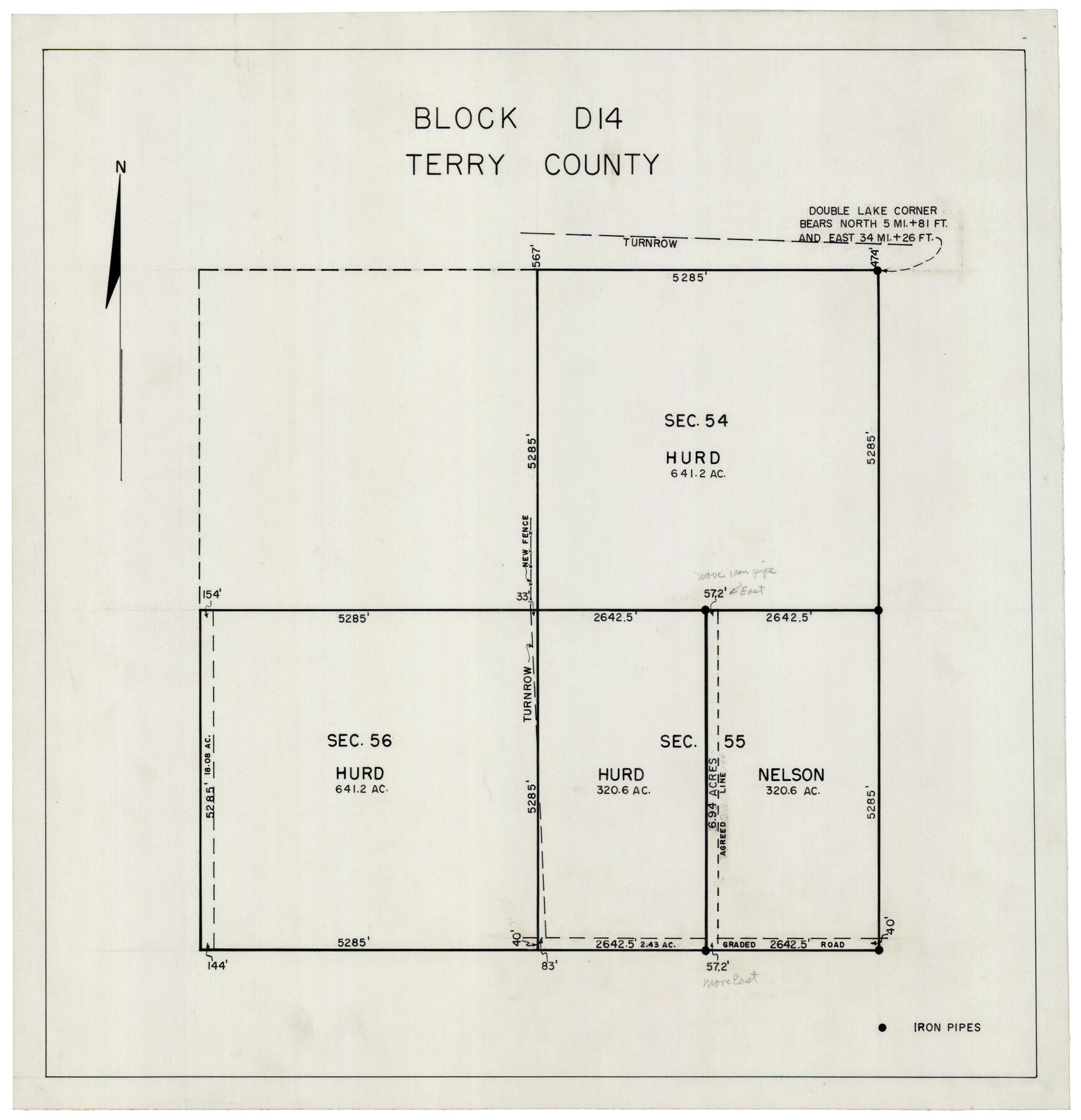
Block D14 Terry County
-
Map/Doc
92416
-
Collection
Twichell Survey Records
-
Counties
Terry
-
Height x Width
17.0 x 17.7 inches
43.2 x 45.0 cm
Part of: Twichell Survey Records
Jeff Davis Co.

Print $20.00
- Digital $50.00
Jeff Davis Co.
1915
Size 26.1 x 28.3 inches
Map/Doc 92175
Burma, Thailand, Indochina and Malayan Federation

Print $3.00
- Digital $50.00
Burma, Thailand, Indochina and Malayan Federation
Size 10.7 x 14.6 inches
Map/Doc 92375
University of Texas System University Lands

Print $20.00
- Digital $50.00
University of Texas System University Lands
1938
Size 17.8 x 23.4 inches
Map/Doc 93247
Land Owned by the Cedar Valley Land and Cattle Co. are M.K.O.

Print $20.00
- Digital $50.00
Land Owned by the Cedar Valley Land and Cattle Co. are M.K.O.
Size 21.4 x 16.5 inches
Map/Doc 91758
[Heirs of Jno. Breeding and surrounding surveys]
![90494, [Heirs of Jno. Breeding and surrounding surveys], Twichell Survey Records](https://historictexasmaps.com/wmedia_w700/maps/90494-1.tif.jpg)
Print $3.00
- Digital $50.00
[Heirs of Jno. Breeding and surrounding surveys]
Size 10.5 x 16.1 inches
Map/Doc 90494
[Part of Eastern Texas RR. Co. Block 1]
![91898, [Part of Eastern Texas RR. Co. Block 1], Twichell Survey Records](https://historictexasmaps.com/wmedia_w700/maps/91898-1.tif.jpg)
Print $20.00
- Digital $50.00
[Part of Eastern Texas RR. Co. Block 1]
Size 21.2 x 12.2 inches
Map/Doc 91898
[Tracing from Mabry's Working Sketch in Southwest Oldham County]
![91474, [Tracing from Mabry's Working Sketch in Southwest Oldham County], Twichell Survey Records](https://historictexasmaps.com/wmedia_w700/maps/91474-1.tif.jpg)
Print $20.00
- Digital $50.00
[Tracing from Mabry's Working Sketch in Southwest Oldham County]
Size 19.3 x 19.8 inches
Map/Doc 91474
Slaton-Tex Water System

Print $20.00
- Digital $50.00
Slaton-Tex Water System
1922
Size 47.7 x 37.6 inches
Map/Doc 92818
Working Sketch in Crane County

Print $20.00
- Digital $50.00
Working Sketch in Crane County
1929
Size 29.2 x 34.3 inches
Map/Doc 90467
![92508, [Block A31], Twichell Survey Records](https://historictexasmaps.com/wmedia_w700/maps/92508-1.tif.jpg)
Plat showing proposed Water Permit on Cow Bayou in Orange County, Texas

Print $20.00
- Digital $50.00
Plat showing proposed Water Permit on Cow Bayou in Orange County, Texas
1922
Size 24.3 x 16.4 inches
Map/Doc 93017
[Subdivision plat of Crockett County School Land Leagues 214-217 and adjacent leagues]
![90253, [Subdivision plat of Crockett County School Land Leagues 214-217 and adjacent leagues], Twichell Survey Records](https://historictexasmaps.com/wmedia_w700/maps/90253-1.tif.jpg)
Print $20.00
- Digital $50.00
[Subdivision plat of Crockett County School Land Leagues 214-217 and adjacent leagues]
Size 26.9 x 19.0 inches
Map/Doc 90253
You may also like
Map of a part of Laguna Madre showing subdivision for mineral development

Print $20.00
- Digital $50.00
Map of a part of Laguna Madre showing subdivision for mineral development
1950
Size 40.7 x 26.9 inches
Map/Doc 2917
Uvalde County Working Sketch 53

Print $20.00
- Digital $50.00
Uvalde County Working Sketch 53
1982
Size 30.4 x 43.0 inches
Map/Doc 72123
Map of Lands surveyed for the Deaf & Dumb Asylum on the head waters of the Leon River

Print $20.00
- Digital $50.00
Map of Lands surveyed for the Deaf & Dumb Asylum on the head waters of the Leon River
1857
Size 13.3 x 17.1 inches
Map/Doc 2209
Gonzales County Working Sketch 5

Print $20.00
- Digital $50.00
Gonzales County Working Sketch 5
1980
Size 31.2 x 43.6 inches
Map/Doc 63221
Montgomery County Working Sketch 24

Print $40.00
- Digital $50.00
Montgomery County Working Sketch 24
1941
Size 35.8 x 52.5 inches
Map/Doc 71131
Outer Continental Shelf Leasing Maps (Louisiana Offshore Operations)

Print $20.00
- Digital $50.00
Outer Continental Shelf Leasing Maps (Louisiana Offshore Operations)
1955
Size 11.2 x 7.4 inches
Map/Doc 76087
Crockett County Rolled Sketch 62

Print $20.00
- Digital $50.00
Crockett County Rolled Sketch 62
1947
Size 27.0 x 38.1 inches
Map/Doc 5605

Harris County Sketch File 49

Print $10.00
- Digital $50.00
Harris County Sketch File 49
1908
Size 11.4 x 9.0 inches
Map/Doc 25446
Matagorda County NRC Article 33.136 Sketch 12

Print $32.00
- Digital $50.00
Matagorda County NRC Article 33.136 Sketch 12
2017
Size 22.0 x 34.0 inches
Map/Doc 94780
Crane County Rolled Sketch 24

Print $40.00
- Digital $50.00
Crane County Rolled Sketch 24
2002
Size 33.5 x 62.0 inches
Map/Doc 76427
The Chief Justice County of Red River. Lands in Conflict with Nacogdoches County

Print $20.00
The Chief Justice County of Red River. Lands in Conflict with Nacogdoches County
2020
Size 17.4 x 21.8 inches
Map/Doc 96066