Donley County Sketch File 26
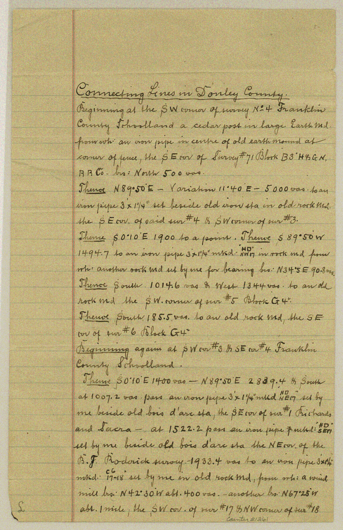
[Connecting line from southwest corner of survey 4, Franklin County School Land to southeast corner of survey 2]
-
Map/Doc
21261
-
Collection
General Map Collection
-
Object Dates
1918/7/12 (File Date)
1918/7/12 (Survey Date)
-
People and Organizations
C.E. Killough (Surveyor/Engineer)
J.B. Wilson (Chainman)
W.R. Black (Chainman)
-
Counties
Donley Armstrong
-
Subjects
Surveying Sketch File
-
Height x Width
12.8 x 8.3 inches
32.5 x 21.1 cm
-
Medium
paper, manuscript
-
Features
Mitchell Peak
Part of: General Map Collection
Galveston County Working Sketch 10

Print $40.00
- Digital $50.00
Galveston County Working Sketch 10
1967
Size 24.7 x 119.8 inches
Map/Doc 69347
Callahan County Sketch File 10

Print $40.00
- Digital $50.00
Callahan County Sketch File 10
Size 21.7 x 24.7 inches
Map/Doc 11039
Pecos County Rolled Sketch 124

Print $20.00
- Digital $50.00
Pecos County Rolled Sketch 124
Size 22.8 x 18.8 inches
Map/Doc 7265
Parker County Sketch File 48

Print $20.00
- Digital $50.00
Parker County Sketch File 48
1858
Size 17.6 x 22.3 inches
Map/Doc 12152

Kimble County Boundary File 3a

Print $36.00
- Digital $50.00
Kimble County Boundary File 3a
Size 8.8 x 8.2 inches
Map/Doc 64859
Flight Mission No. BRA-16M, Frame 137, Jefferson County

Print $20.00
- Digital $50.00
Flight Mission No. BRA-16M, Frame 137, Jefferson County
1953
Size 18.7 x 22.3 inches
Map/Doc 85743
Cass County Rolled Sketch OPD

Print $20.00
- Digital $50.00
Cass County Rolled Sketch OPD
1936
Size 29.6 x 24.9 inches
Map/Doc 5415
Harrison County Rolled Sketch 8

Print $33.00
- Digital $50.00
Harrison County Rolled Sketch 8
Size 10.1 x 15.2 inches
Map/Doc 45825
Lipscomb County Working Sketch Graphic Index

Print $20.00
- Digital $50.00
Lipscomb County Working Sketch Graphic Index
1899
Size 41.4 x 38.4 inches
Map/Doc 76622
Zavala County Working Sketch 29

Print $20.00
- Digital $50.00
Zavala County Working Sketch 29
1994
Size 33.1 x 42.9 inches
Map/Doc 62104
Flight Mission No. DQN-1K, Frame 156, Calhoun County

Print $20.00
- Digital $50.00
Flight Mission No. DQN-1K, Frame 156, Calhoun County
1953
Size 18.6 x 22.3 inches
Map/Doc 84215
You may also like
Revised Sectional Map No. 6 showing land surveys in parts of Presidio and Brewster Counties, Texas

Print $20.00
- Digital $50.00
Revised Sectional Map No. 6 showing land surveys in parts of Presidio and Brewster Counties, Texas
Size 24.2 x 23.0 inches
Map/Doc 4475
Floyd County Boundary File 4

Print $4.00
- Digital $50.00
Floyd County Boundary File 4
Size 11.2 x 8.9 inches
Map/Doc 53494
Flight Mission No. CRE-2R, Frame 90, Jackson County

Print $20.00
- Digital $50.00
Flight Mission No. CRE-2R, Frame 90, Jackson County
1956
Size 16.0 x 15.8 inches
Map/Doc 85362
Moore County Sketch File 13

Print $24.00
- Digital $50.00
Moore County Sketch File 13
1919
Size 7.0 x 8.7 inches
Map/Doc 31949
Parker County Working Sketch 9

Print $20.00
- Digital $50.00
Parker County Working Sketch 9
1958
Map/Doc 71459
McMullen County Working Sketch 18

Print $20.00
- Digital $50.00
McMullen County Working Sketch 18
1943
Size 17.0 x 16.6 inches
Map/Doc 70719
Motley County Sketch File 12 (N)

Print $3.00
- Digital $50.00
Motley County Sketch File 12 (N)
Size 20.0 x 18.4 inches
Map/Doc 42141
Jasper County Sketch File 15

Print $6.00
- Digital $50.00
Jasper County Sketch File 15
Size 9.9 x 15.3 inches
Map/Doc 27806

Flight Mission No. BRA-16M, Frame 180, Jefferson County

Print $20.00
- Digital $50.00
Flight Mission No. BRA-16M, Frame 180, Jefferson County
1953
Size 18.5 x 22.4 inches
Map/Doc 85778
Val Verde County Working Sketch 83

Print $40.00
- Digital $50.00
Val Verde County Working Sketch 83
1973
Size 28.7 x 53.6 inches
Map/Doc 72218
Copy of Surveyor's Field Book, Morris Browning - In Blocks 7, 5 & 4, I&GNRRCo., Hutchinson and Carson Counties, Texas

Print $2.00
- Digital $50.00
Copy of Surveyor's Field Book, Morris Browning - In Blocks 7, 5 & 4, I&GNRRCo., Hutchinson and Carson Counties, Texas
1888
Size 7.0 x 8.8 inches
Map/Doc 62259