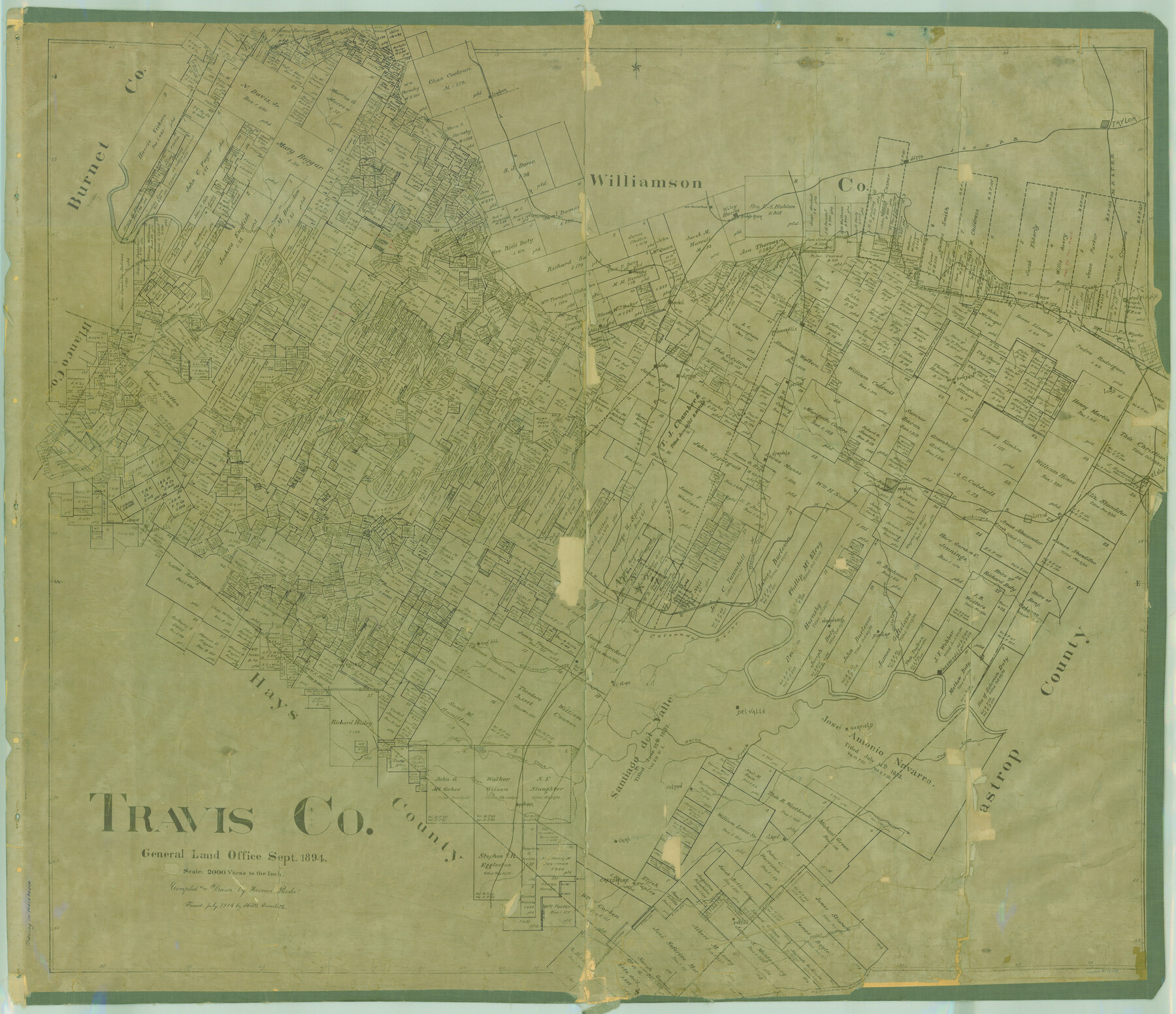
Travis Co.
-
Map/Doc
78388
-
Collection
General Map Collection
-
Object Dates
1894 (Creation Date)
-
People and Organizations
Texas General Land Office (Publisher)
Herman Pressler (Compiler)
Herman Pressler (Draftsman)
-
Counties
Travis
-
Subjects
County
-
Height x Width
41.6 x 48.3 inches
105.7 x 122.7 cm
-
Comments
Traced in July 1914 by H. M. Bramlette.
Note on reverse side: "Copied and hung April 1927 MKB; In use to Nov. 2, 1936".
Help Save Texas History - Adopt Me! -
Features
Grape Creek
Onion Creek
Cedar Creek
Garfield
Cedar Valley
Oak Hill
Williamson Creek
St. Elmo
Webberville
Dunlap
Colorado River
Boggy Creek
Rocky Creek
Neps Branch [of Barton Creek]
Barton Creek
Congress Avenue Bridge
Waller Creek
Austin
Hornsby
Gilleland Creek
Walnut Creek
Little Barton Creek
Nacogdoches Road
Shoal Creek
TCRR
Dead Man's Creek
Hale Creek
Basin Branch of Cypress Creek
Clear Creek
Turner's Branch [of Pedernales River]
Lion Creek
Old San Antonio to Nacogdoches Road
Del Valle
Shingle Hill
Old San Antonio Road
Evelyn
Creedmore
Carl
Elroy
Rock Springs Branch [of Cedar Creek]
Colton
Manchaca
Bear Creek
Slaughter Creek
Brushy Creek
Lund
New Sweden
Pflugerville
Jollyville
Cross Creek
Mud
Pedernales River
Red Bluffs Creek
Deer Creek
Cummings
Dessau
Round Rock
Cedar Park
Cow Creek
Sandy Creek
Cherry Hollow Creek
Old Round Rock
MK&T
Taylor
I&GN
Hutto
Jolly Creek
Bee Cave
Littig
Wilbarger Creek
H&TC
A&NW
Devil's Cañon
Cypress Creek
Basin Branch of Pedernales River
Cat Hollow Creek
Bee Creek
Leander
Harrison Branch [of Pedernales River]
Turkey Creek
Bull Creek
Sprinkle
Manor
Elgin
Cougar Branch [of Pedernales River]
Teck
Duval
Watters
Part of: General Map Collection
Midland County Working Sketch 15

Print $20.00
- Digital $50.00
Midland County Working Sketch 15
1953
Size 27.2 x 28.6 inches
Map/Doc 70995
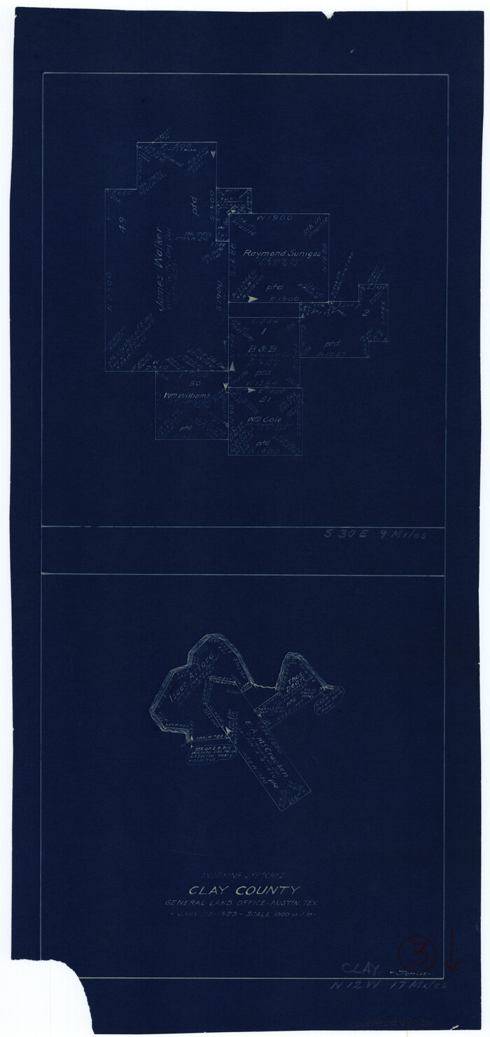
Clay County Sketch File 9a

Print $6.00
- Digital $50.00
Clay County Sketch File 9a
1855
Size 10.7 x 6.1 inches
Map/Doc 18403
Williamson County Boundary File 1

Print $66.00
- Digital $50.00
Williamson County Boundary File 1
Size 8.4 x 6.0 inches
Map/Doc 59974
Winkler County Sketch File 16

Print $30.00
- Digital $50.00
Winkler County Sketch File 16
1929
Size 14.2 x 8.7 inches
Map/Doc 40493
Wise County Working Sketch 15

Print $20.00
- Digital $50.00
Wise County Working Sketch 15
1979
Size 23.3 x 24.6 inches
Map/Doc 72629
Frio County Rolled Sketch 27

Print $20.00
- Digital $50.00
Frio County Rolled Sketch 27
2013
Size 36.0 x 24.6 inches
Map/Doc 93417
Map of Hays County, Texas

Print $20.00
- Digital $50.00
Map of Hays County, Texas
1880
Size 41.8 x 35.8 inches
Map/Doc 16848
Newton County

Print $40.00
- Digital $50.00
Newton County
1946
Size 48.7 x 41.9 inches
Map/Doc 66953
Nueces County Sketch File 14

Print $20.00
- Digital $50.00
Nueces County Sketch File 14
Size 18.3 x 20.8 inches
Map/Doc 42179
Presidio County Working Sketch 147

Print $20.00
- Digital $50.00
Presidio County Working Sketch 147
Size 24.5 x 43.1 inches
Map/Doc 71825
Presidio County Working Sketch 67

Print $20.00
- Digital $50.00
Presidio County Working Sketch 67
1960
Size 36.2 x 36.5 inches
Map/Doc 71744
Trinity River, Terrell Sheet/Kings Creek

Print $20.00
- Digital $50.00
Trinity River, Terrell Sheet/Kings Creek
1930
Size 42.3 x 19.7 inches
Map/Doc 65229
You may also like
Kinney County Rolled Sketch 2

Print $20.00
- Digital $50.00
Kinney County Rolled Sketch 2
Size 24.5 x 36.2 inches
Map/Doc 6534
Llano County Sketch File 3

Print $6.00
- Digital $50.00
Llano County Sketch File 3
1874
Size 8.0 x 8.9 inches
Map/Doc 30350
Kerr County Sketch File 2

Print $8.00
- Digital $50.00
Kerr County Sketch File 2
1859
Size 10.5 x 7.5 inches
Map/Doc 28856
Hall County Sketch File B2

Print $20.00
- Digital $50.00
Hall County Sketch File B2
1904
Size 21.7 x 35.1 inches
Map/Doc 11613
Terrell County Working Sketch 82

Print $20.00
- Digital $50.00
Terrell County Working Sketch 82
1991
Size 31.7 x 24.8 inches
Map/Doc 69603
Burnet County Highway Map

Print $20.00
- Digital $50.00
Burnet County Highway Map
Size 25.5 x 18.5 inches
Map/Doc 92471
Neches River, Watershed of the Neches River

Print $6.00
- Digital $50.00
Neches River, Watershed of the Neches River
1925
Size 34.6 x 28.3 inches
Map/Doc 65085
General Highway Map, San Augustine County, Texas

Print $20.00
General Highway Map, San Augustine County, Texas
1940
Size 24.8 x 18.3 inches
Map/Doc 79235
Clay County Working Sketch 3
Print $20.00
- Digital $50.00
Clay County Working Sketch 3
1923
Size 19.7 x 9.3 inches
Map/Doc 68026
Trinity County Sketch File 35a

Print $6.00
- Digital $50.00
Trinity County Sketch File 35a
1921
Size 16.8 x 8.8 inches
Map/Doc 38587
Donley County Rolled Sketch 1

Print $20.00
- Digital $50.00
Donley County Rolled Sketch 1
1939
Size 19.6 x 15.1 inches
Map/Doc 5728
The Republic County of Milam. Proposed, Late Fall 1837-December 31, 1838

Print $20.00
The Republic County of Milam. Proposed, Late Fall 1837-December 31, 1838
2020
Size 17.4 x 21.6 inches
Map/Doc 96226