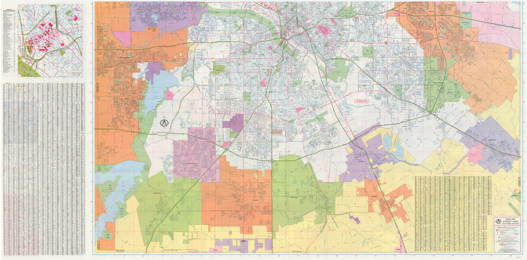
Dallas
[Verso: Dallas Street Map - Southern Section]
-
Map/Doc
94419
-
Collection
General Map Collection
-
People and Organizations
Rand McNally & Co. (Publisher)
-
Counties
Dallas
-
Subjects
City
-
Height x Width
26.9 x 54.2 inches
68.3 x 137.7 cm
-
Medium
paper, etching/engraving/lithograph
-
Comments
See 94418 for Northern Section on recto.
Related maps

Part of: General Map Collection
Menard County Working Sketch 10

Print $20.00
- Digital $50.00
Menard County Working Sketch 10
1938
Size 21.8 x 18.5 inches
Map/Doc 70957
Castro County Sketch File 5a

Print $8.00
- Digital $50.00
Castro County Sketch File 5a
1904
Size 11.2 x 8.7 inches
Map/Doc 17491
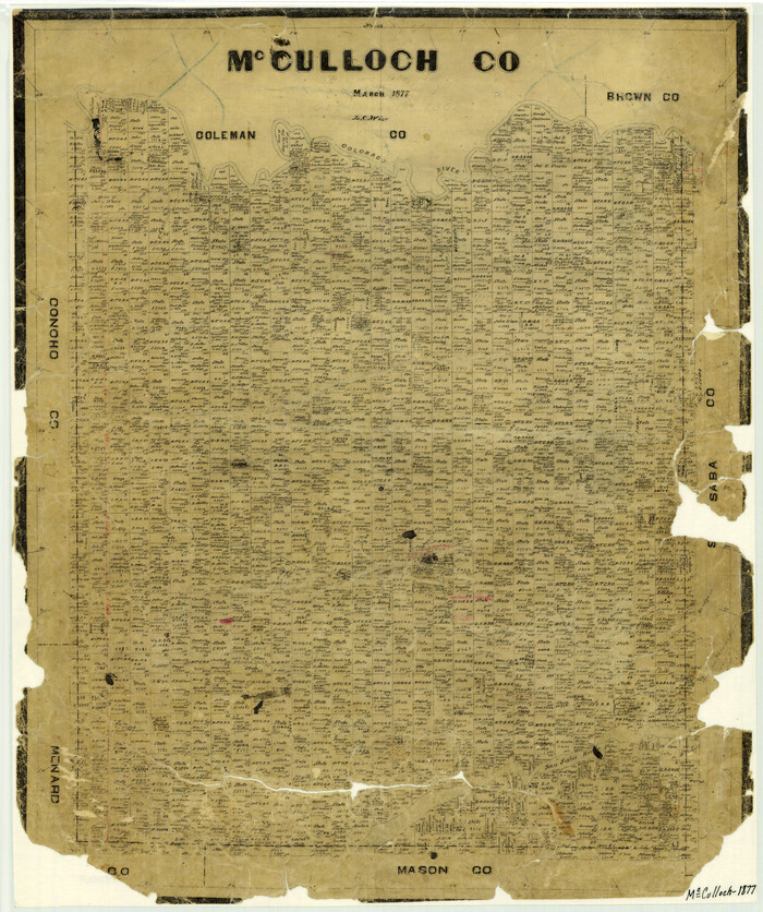
McCulloch County
Print $20.00
- Digital $50.00
McCulloch County
1877
Size 21.3 x 17.9 inches
Map/Doc 3858
Mitchell County Boundary File 66a

Print $11.00
- Digital $50.00
Mitchell County Boundary File 66a
Size 12.6 x 8.3 inches
Map/Doc 57378
Denton County Boundary File 1

Print $14.00
- Digital $50.00
Denton County Boundary File 1
Size 8.7 x 3.5 inches
Map/Doc 52394
Webb County Working Sketch Graphic Index - northeast part

Print $20.00
- Digital $50.00
Webb County Working Sketch Graphic Index - northeast part
1986
Size 35.7 x 47.1 inches
Map/Doc 76734
Pecos County Sketch File 83

Print $6.00
- Digital $50.00
Pecos County Sketch File 83
1884
Size 11.3 x 8.7 inches
Map/Doc 33950
Edwards County Sketch File 56

Print $32.00
- Digital $50.00
Edwards County Sketch File 56
1915
Size 11.4 x 9.0 inches
Map/Doc 21808
Ochiltree County

Print $20.00
- Digital $50.00
Ochiltree County
1958
Size 41.0 x 33.1 inches
Map/Doc 77386
Liberty County Rolled Sketch N

Print $20.00
- Digital $50.00
Liberty County Rolled Sketch N
1954
Size 45.1 x 39.1 inches
Map/Doc 10721
Flight Mission No. DQO-8K, Frame 83, Galveston County

Print $20.00
- Digital $50.00
Flight Mission No. DQO-8K, Frame 83, Galveston County
1952
Size 18.7 x 22.3 inches
Map/Doc 85185
Travis County Sketch File 75

Print $2.00
- Digital $50.00
Travis County Sketch File 75
1992
Size 11.2 x 8.9 inches
Map/Doc 38473
You may also like
Kendall County Working Sketch 4

Print $20.00
- Digital $50.00
Kendall County Working Sketch 4
1946
Size 25.7 x 24.3 inches
Map/Doc 66676
Galveston County NRC Article 33.136 Sketch 17

Print $22.00
- Digital $50.00
Galveston County NRC Article 33.136 Sketch 17
2002
Size 24.1 x 36.4 inches
Map/Doc 78584
Liberty County Working Sketch 54

Print $20.00
- Digital $50.00
Liberty County Working Sketch 54
1962
Size 29.8 x 29.5 inches
Map/Doc 70514
Houston County Working Sketch 29

Print $20.00
- Digital $50.00
Houston County Working Sketch 29
1990
Size 23.4 x 23.1 inches
Map/Doc 66259

Foard County Boundary File 6

Print $10.00
- Digital $50.00
Foard County Boundary File 6
Size 7.2 x 8.7 inches
Map/Doc 53548
[Maps of surveys in Reeves & Culberson Cos]
![61139, [Maps of surveys in Reeves & Culberson Cos], General Map Collection](https://historictexasmaps.com/wmedia_w700/maps/61139.tif.jpg)
Print $20.00
- Digital $50.00
[Maps of surveys in Reeves & Culberson Cos]
1937
Size 30.7 x 24.7 inches
Map/Doc 61139
Coke County Working Sketch Graphic Index

Print $20.00
- Digital $50.00
Coke County Working Sketch Graphic Index
1945
Size 38.9 x 41.5 inches
Map/Doc 76496
Trip to the West and Texas Comprising a Journey of Eight Thousand Miles, Through New-York, Michigan, Illinois, Missouri, Louisiana and Texas, in the Autumn and Winter of 1834-5. Interspersed with Anecdotes, Incidents and Observations. With a Brief Sketch

Trip to the West and Texas Comprising a Journey of Eight Thousand Miles, Through New-York, Michigan, Illinois, Missouri, Louisiana and Texas, in the Autumn and Winter of 1834-5. Interspersed with Anecdotes, Incidents and Observations. With a Brief Sketch
1836
Map/Doc 97078
English Field Notes of the Spanish Archives - Book 6

English Field Notes of the Spanish Archives - Book 6
1836
Map/Doc 96532
Red River, Water-Shed of Cypress Creek in Texas Drainage Area

Print $4.00
- Digital $50.00
Red River, Water-Shed of Cypress Creek in Texas Drainage Area
1925
Size 16.3 x 19.2 inches
Map/Doc 65057
Midland County Boundary File 4a

Print $40.00
- Digital $50.00
Midland County Boundary File 4a
Size 36.2 x 54.5 inches
Map/Doc 57185