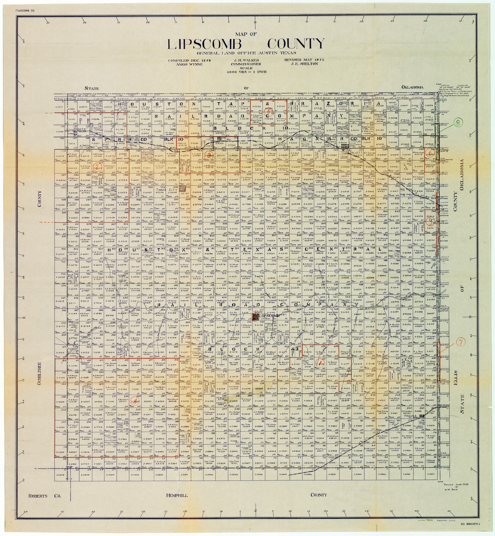
Lipscomb County Working Sketch Graphic Index
-
Map/Doc
76622
-
Collection
General Map Collection
-
Object Dates
12/1899 (Creation Date)
5/1932 (Revision Date)
-
People and Organizations
Amos Wynne (Compiler)
J.E. Shelton (Draftsman)
-
Counties
Lipscomb
-
Subjects
County Surveying Working Sketch
-
Height x Width
41.4 x 38.4 inches
105.2 x 97.5 cm
-
Scale
1" = 2000 varas
Part of: General Map Collection
Castro County Sketch File 4l

Print $4.00
- Digital $50.00
Castro County Sketch File 4l
Size 13.5 x 8.6 inches
Map/Doc 17487
Mason County Working Sketch 12

Print $20.00
- Digital $50.00
Mason County Working Sketch 12
1951
Size 28.1 x 23.6 inches
Map/Doc 70848

Hall County Rolled Sketch C

Print $20.00
- Digital $50.00
Hall County Rolled Sketch C
1902
Size 32.7 x 46.4 inches
Map/Doc 76023
Reeves County Rolled Sketch 16

Print $20.00
- Digital $50.00
Reeves County Rolled Sketch 16
1963
Size 22.3 x 27.3 inches
Map/Doc 7485
PSL Field Notes for Blocks 15 through 29 in Hudspeth County

PSL Field Notes for Blocks 15 through 29 in Hudspeth County
Map/Doc 81659
Rusk County Sketch File 27B

Print $20.00
Rusk County Sketch File 27B
1936
Size 15.4 x 19.9 inches
Map/Doc 12273
Travis County Working Sketch 3

Print $20.00
- Digital $50.00
Travis County Working Sketch 3
1906
Size 19.5 x 15.0 inches
Map/Doc 69387
Trinity County Rolled Sketch 2

Print $20.00
- Digital $50.00
Trinity County Rolled Sketch 2
1948
Size 34.5 x 34.9 inches
Map/Doc 10024
Red River County Texas

Print $20.00
- Digital $50.00
Red River County Texas
1879
Size 23.7 x 20.1 inches
Map/Doc 3978
Uvalde County Working Sketch 59

Print $20.00
- Digital $50.00
Uvalde County Working Sketch 59
1989
Size 25.1 x 39.1 inches
Map/Doc 72129
Flight Mission No. CLL-3N, Frame 36, Willacy County

Print $20.00
- Digital $50.00
Flight Mission No. CLL-3N, Frame 36, Willacy County
1954
Size 18.4 x 22.2 inches
Map/Doc 87094
You may also like
Padre Island National Seashore

Print $4.00
- Digital $50.00
Padre Island National Seashore
Size 16.2 x 22.2 inches
Map/Doc 60533
Stonewall County Sketch File 4

Print $20.00
- Digital $50.00
Stonewall County Sketch File 4
Size 18.2 x 25.7 inches
Map/Doc 12363
Denton County Sketch File 6

Print $4.00
- Digital $50.00
Denton County Sketch File 6
1855
Size 12.3 x 8.3 inches
Map/Doc 20696
Hansford County Working Sketch Graphic Index

Print $20.00
- Digital $50.00
Hansford County Working Sketch Graphic Index
1932
Size 39.2 x 38.2 inches
Map/Doc 76565
Presidio County Sketch File 64

Print $20.00
- Digital $50.00
Presidio County Sketch File 64
1938
Size 16.5 x 26.5 inches
Map/Doc 11719
Hutchinson County Rolled Sketch 44-14

Print $20.00
- Digital $50.00
Hutchinson County Rolled Sketch 44-14
2002
Size 24.0 x 36.0 inches
Map/Doc 77550


Midland County Rolled Sketch 4

Print $40.00
- Digital $50.00
Midland County Rolled Sketch 4
Size 43.5 x 85.6 inches
Map/Doc 10696
The Republic County of Jasper. Boundaries Defined, December 14, 1837

Print $20.00
The Republic County of Jasper. Boundaries Defined, December 14, 1837
2020
Size 19.5 x 21.7 inches
Map/Doc 96193
Palo Pinto County Working Sketch 16

Print $20.00
- Digital $50.00
Palo Pinto County Working Sketch 16
1974
Size 35.5 x 42.4 inches
Map/Doc 71399
[Sketch Showing Connections Between Blocks X, RG, and A]
![91375, [Sketch Showing Connections Between Blocks X, RG, and A], Twichell Survey Records](https://historictexasmaps.com/wmedia_w700/maps/91375-1.tif.jpg)
Print $20.00
- Digital $50.00
[Sketch Showing Connections Between Blocks X, RG, and A]
Size 17.5 x 26.0 inches
Map/Doc 91375