Callahan County Sketch File 10
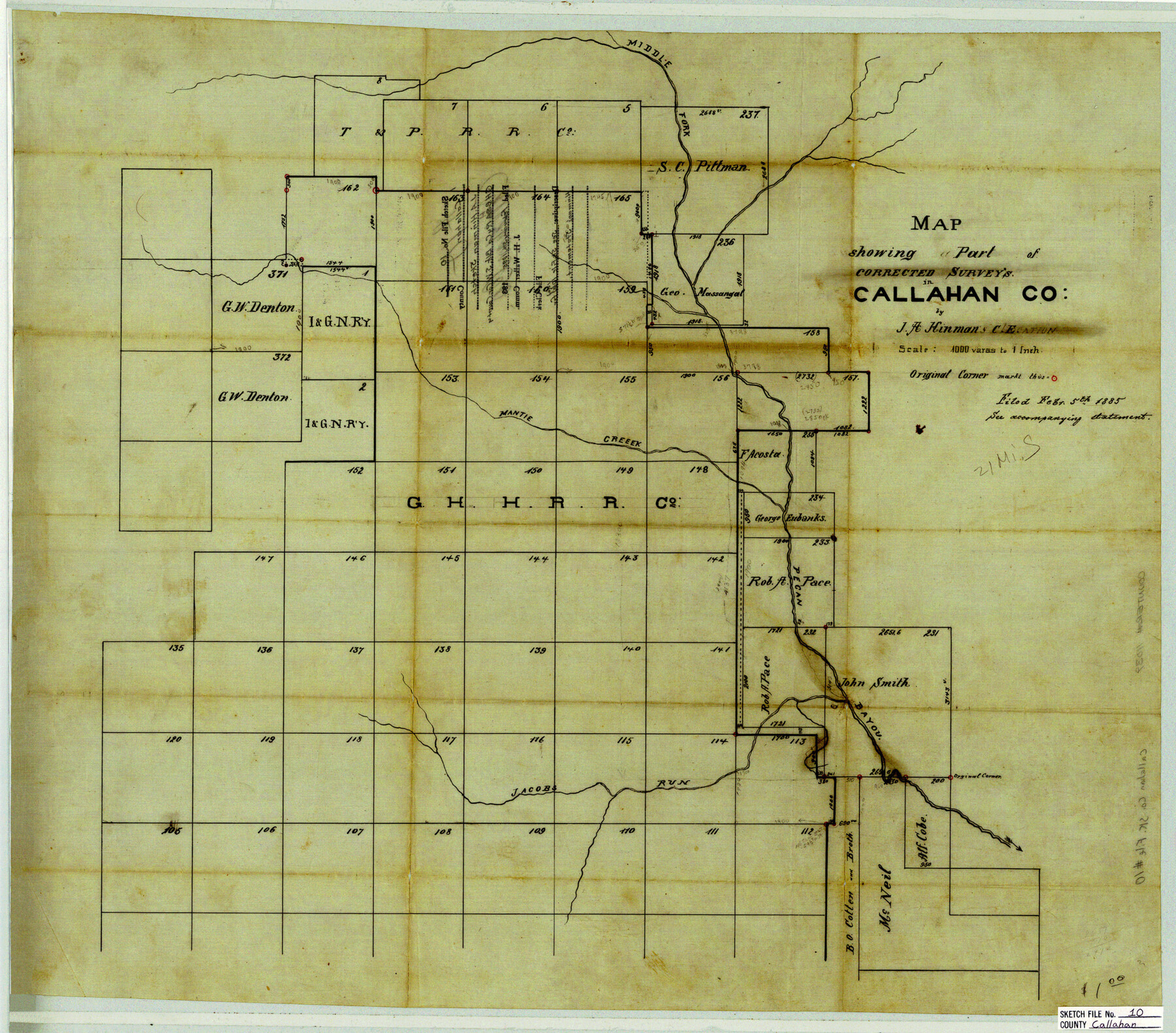
Map showing part of corrected [G. H. & H. Ry. Co. and surrounding] surveys in [southwest part of] Callahan Co.
-
Map/Doc
11039
-
Collection
General Map Collection
-
Object Dates
1885/2/5 (File Date)
-
People and Organizations
J.A. Hinman (Surveyor/Engineer)
-
Counties
Coleman Callahan
-
Subjects
Surveying Sketch File
-
Height x Width
21.7 x 24.7 inches
55.1 x 62.7 cm
-
Medium
paper, manuscript
-
Scale
1" = 1000 varas
-
Comments
See Callahan County Sketch File 10a (35873) for surveyor's statement.
-
Features
Middle Fork [of Pecan Bayou]
Mantie Creek
Pecan Bayou
Jacobs Run
Related maps
Callahan County Sketch File 10a

Print $20.00
- Digital $50.00
Callahan County Sketch File 10a
1885
Size 14.3 x 8.8 inches
Map/Doc 35873
Part of: General Map Collection
Flight Mission No. BRA-16M, Frame 53, Jefferson County

Print $20.00
- Digital $50.00
Flight Mission No. BRA-16M, Frame 53, Jefferson County
1953
Size 18.4 x 22.6 inches
Map/Doc 85670
Reeves County Working Sketch 26

Print $20.00
- Digital $50.00
Reeves County Working Sketch 26
1967
Size 44.5 x 36.0 inches
Map/Doc 63469
Coryell County Working Sketch Graphic Index

Print $20.00
- Digital $50.00
Coryell County Working Sketch Graphic Index
1936
Size 44.8 x 40.5 inches
Map/Doc 76505
Rains County Sketch File 1

Print $6.00
- Digital $50.00
Rains County Sketch File 1
Size 5.9 x 9.1 inches
Map/Doc 34942
Comanche County

Print $20.00
- Digital $50.00
Comanche County
1879
Size 23.0 x 24.7 inches
Map/Doc 944

Intracoastal Waterway in Texas - Corpus Christi to Point Isabel including Arroyo Colorado to Mo. Pac. R.R. Bridge Near Harlingen

Print $20.00
- Digital $50.00
Intracoastal Waterway in Texas - Corpus Christi to Point Isabel including Arroyo Colorado to Mo. Pac. R.R. Bridge Near Harlingen
1934
Size 21.8 x 32.7 inches
Map/Doc 61885
Galveston County NRC Article 33.136 Sketch 54

Print $22.00
- Digital $50.00
Galveston County NRC Article 33.136 Sketch 54
2008
Size 24.0 x 36.0 inches
Map/Doc 94848
Cottle County Rolled Sketch 15

Print $20.00
- Digital $50.00
Cottle County Rolled Sketch 15
2004
Size 37.2 x 37.2 inches
Map/Doc 82849

Bailey County Sketch File 6

Print $40.00
- Digital $50.00
Bailey County Sketch File 6
Size 26.5 x 31.9 inches
Map/Doc 10884
Kimble County Working Sketch 97

Print $20.00
- Digital $50.00
Kimble County Working Sketch 97
2012
Size 42.8 x 36.6 inches
Map/Doc 93388
You may also like
Mitchell County Sketch File 10

Print $4.00
- Digital $50.00
Mitchell County Sketch File 10
1909
Size 11.3 x 8.8 inches
Map/Doc 31698
The Republic County of Gonzales. Boundaries Defined, December 14, 1837

Print $20.00
The Republic County of Gonzales. Boundaries Defined, December 14, 1837
2020
Size 14.7 x 21.7 inches
Map/Doc 96153
Ochiltree County Working Sketch 5

Print $40.00
- Digital $50.00
Ochiltree County Working Sketch 5
1961
Size 110.0 x 37.3 inches
Map/Doc 71318
Bandera County Rolled Sketch 9

Print $20.00
- Digital $50.00
Bandera County Rolled Sketch 9
Size 21.2 x 24.2 inches
Map/Doc 5120
Mills County Sketch File 18

Print $4.00
- Digital $50.00
Mills County Sketch File 18
1872
Size 12.1 x 8.1 inches
Map/Doc 31668
Reeves County Working Sketch 36

Print $20.00
- Digital $50.00
Reeves County Working Sketch 36
1970
Size 43.1 x 35.0 inches
Map/Doc 63479
[Rusk, Sutton, and Atascosa County School Lands]
![91124, [Rusk, Sutton, and Atascosa County School Lands], Twichell Survey Records](https://historictexasmaps.com/wmedia_w700/maps/91124-1.tif.jpg)
Print $2.00
- Digital $50.00
[Rusk, Sutton, and Atascosa County School Lands]
Size 6.0 x 7.1 inches
Map/Doc 91124
[Worksheets related to the Wilson Strickland survey and vicinity]
![91267, [Vicinity and related to the Wilson Strickland Survey], Twichell Survey Records](https://historictexasmaps.com/wmedia_w700/maps/91267-1.tif.jpg)
Print $20.00
- Digital $50.00
[Worksheets related to the Wilson Strickland survey and vicinity]
Size 21.7 x 19.4 inches
Map/Doc 91267
[Block B5, Capitol Leagues 217, 218, and 239]
![91438, [Block B5, Capitol Leagues 217, 218, and 239], Twichell Survey Records](https://historictexasmaps.com/wmedia_w700/maps/91438-1.tif.jpg)
Print $3.00
- Digital $50.00
[Block B5, Capitol Leagues 217, 218, and 239]
Size 15.1 x 10.0 inches
Map/Doc 91438
Chambers County Sketch File 10b

Print $4.00
- Digital $50.00
Chambers County Sketch File 10b
1841
Size 9.6 x 8.2 inches
Map/Doc 17552
General Highway Map, Montague County, Texas

Print $20.00
General Highway Map, Montague County, Texas
1961
Size 24.8 x 18.2 inches
Map/Doc 79601
Jeff Davis County Working Sketch 26

Print $20.00
- Digital $50.00
Jeff Davis County Working Sketch 26
1960
Size 22.0 x 32.6 inches
Map/Doc 66521