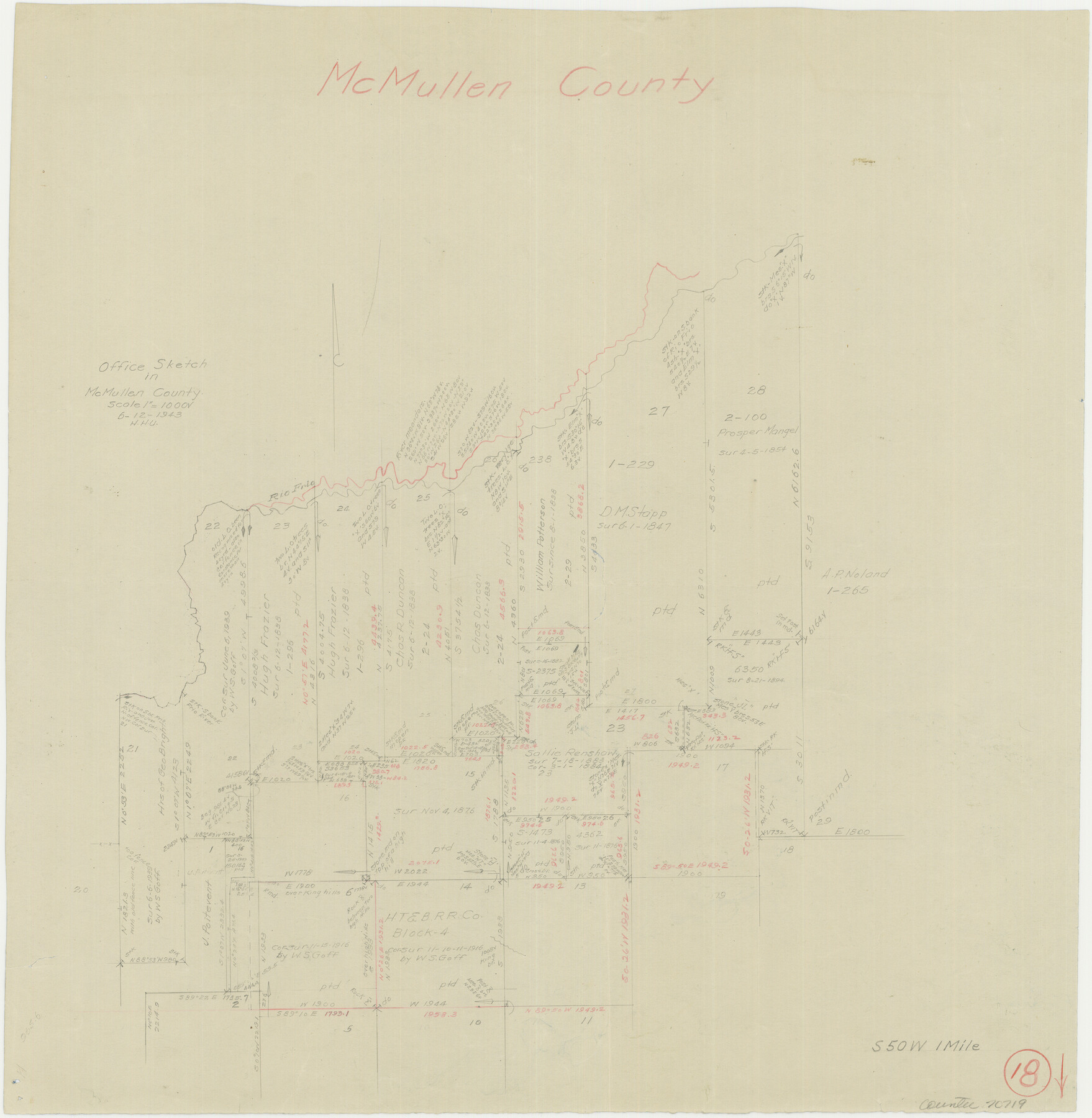
McMullen County Working Sketch 18
-
Map/Doc
70719
-
Collection
General Map Collection
-
Object Dates
6/12/1943 (Creation Date)
-
People and Organizations
Herbert H. Ulbricht (Draftsman)
-
Counties
McMullen
-
Subjects
Surveying Working Sketch
-
Height x Width
17.0 x 16.6 inches
43.2 x 42.2 cm
-
Scale
1" = 1000 varas
Part of: General Map Collection
Map of New England and New York to illustrate Olney's school geography

Print $20.00
- Digital $50.00
Map of New England and New York to illustrate Olney's school geography
1844
Size 12.1 x 19.0 inches
Map/Doc 93538
Culberson County Sketch File 25

Print $6.00
- Digital $50.00
Culberson County Sketch File 25
Size 11.2 x 8.8 inches
Map/Doc 20259
Gray County Working Sketch Graphic Index

Print $20.00
- Digital $50.00
Gray County Working Sketch Graphic Index
1900
Size 43.3 x 39.4 inches
Map/Doc 76557
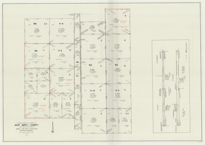
Deaf Smith County Working Sketch 4
Print $40.00
- Digital $50.00
Deaf Smith County Working Sketch 4
1983
Size 37.0 x 52.4 inches
Map/Doc 68644
Val Verde County Working Sketch 70

Print $20.00
- Digital $50.00
Val Verde County Working Sketch 70
1966
Size 21.2 x 28.0 inches
Map/Doc 72205
Flight Mission No. BQR-4K, Frame 58, Brazoria County

Print $20.00
- Digital $50.00
Flight Mission No. BQR-4K, Frame 58, Brazoria County
1952
Size 18.7 x 22.4 inches
Map/Doc 83991
Refugio County Texas

Print $20.00
- Digital $50.00
Refugio County Texas
1896
Size 20.3 x 26.9 inches
Map/Doc 3985
Yoakum County Rolled Sketch 6

Print $20.00
- Digital $50.00
Yoakum County Rolled Sketch 6
Size 18.7 x 34.6 inches
Map/Doc 8291
Aransas County Aerial Photograph Index Sheet 3

Print $20.00
- Digital $50.00
Aransas County Aerial Photograph Index Sheet 3
1957
Size 22.8 x 18.1 inches
Map/Doc 83661
Controlled Mosaic by Jack Amman Photogrammetric Engineers, Inc - Sheet 21

Print $20.00
- Digital $50.00
Controlled Mosaic by Jack Amman Photogrammetric Engineers, Inc - Sheet 21
1954
Size 20.0 x 24.0 inches
Map/Doc 83470
Johnson County Boundary File 51b

Print $80.00
- Digital $50.00
Johnson County Boundary File 51b
Size 53.9 x 9.4 inches
Map/Doc 55619
University Lands Blocks 29-33, Crockett County, Texas

Print $20.00
- Digital $50.00
University Lands Blocks 29-33, Crockett County, Texas
Size 29.7 x 44.1 inches
Map/Doc 62943
You may also like
Rains County Working Sketch 1

Print $20.00
- Digital $50.00
Rains County Working Sketch 1
Size 12.3 x 17.3 inches
Map/Doc 71827
Duval County Sketch File 48

Print $8.00
- Digital $50.00
Duval County Sketch File 48
1935
Size 14.2 x 8.8 inches
Map/Doc 21405
Shelby County Sketch File 20 1/2

Print $4.00
- Digital $50.00
Shelby County Sketch File 20 1/2
1890
Size 6.6 x 8.4 inches
Map/Doc 36640
Flight Mission No. DQO-6K, Frame 34, Galveston County

Print $20.00
- Digital $50.00
Flight Mission No. DQO-6K, Frame 34, Galveston County
1952
Size 18.7 x 22.4 inches
Map/Doc 85100
Lamb County Sketch File 15

Print $6.00
- Digital $50.00
Lamb County Sketch File 15
Size 9.8 x 10.9 inches
Map/Doc 29377
Guadalupe County Working Sketch 12

Print $20.00
- Digital $50.00
Guadalupe County Working Sketch 12
2005
Size 29.1 x 23.5 inches
Map/Doc 83571
Borden County Working Sketch 14

Print $20.00
- Digital $50.00
Borden County Working Sketch 14
1959
Size 27.8 x 25.2 inches
Map/Doc 67474
Travis County Rolled Sketch 47

Print $40.00
- Digital $50.00
Travis County Rolled Sketch 47
1928
Size 57.3 x 26.1 inches
Map/Doc 10627
Jasper County Rolled Sketch 1

Print $20.00
- Digital $50.00
Jasper County Rolled Sketch 1
Size 11.1 x 18.0 inches
Map/Doc 6347
[Surveys Surrounding I. G. Yates S.F. 12394]
![91560, [Surveys Surrounding I. G. Yates S.F. 12394], Twichell Survey Records](https://historictexasmaps.com/wmedia_w700/maps/91560-1.tif.jpg)
Print $20.00
- Digital $50.00
[Surveys Surrounding I. G. Yates S.F. 12394]
Size 18.6 x 7.4 inches
Map/Doc 91560
Matagorda Light to Aransas Pass

Print $20.00
- Digital $50.00
Matagorda Light to Aransas Pass
1957
Size 35.8 x 44.7 inches
Map/Doc 73395
No. 2 Chart of Corpus Christi Pass, Texas

Print $20.00
- Digital $50.00
No. 2 Chart of Corpus Christi Pass, Texas
1878
Size 18.3 x 27.4 inches
Map/Doc 73022