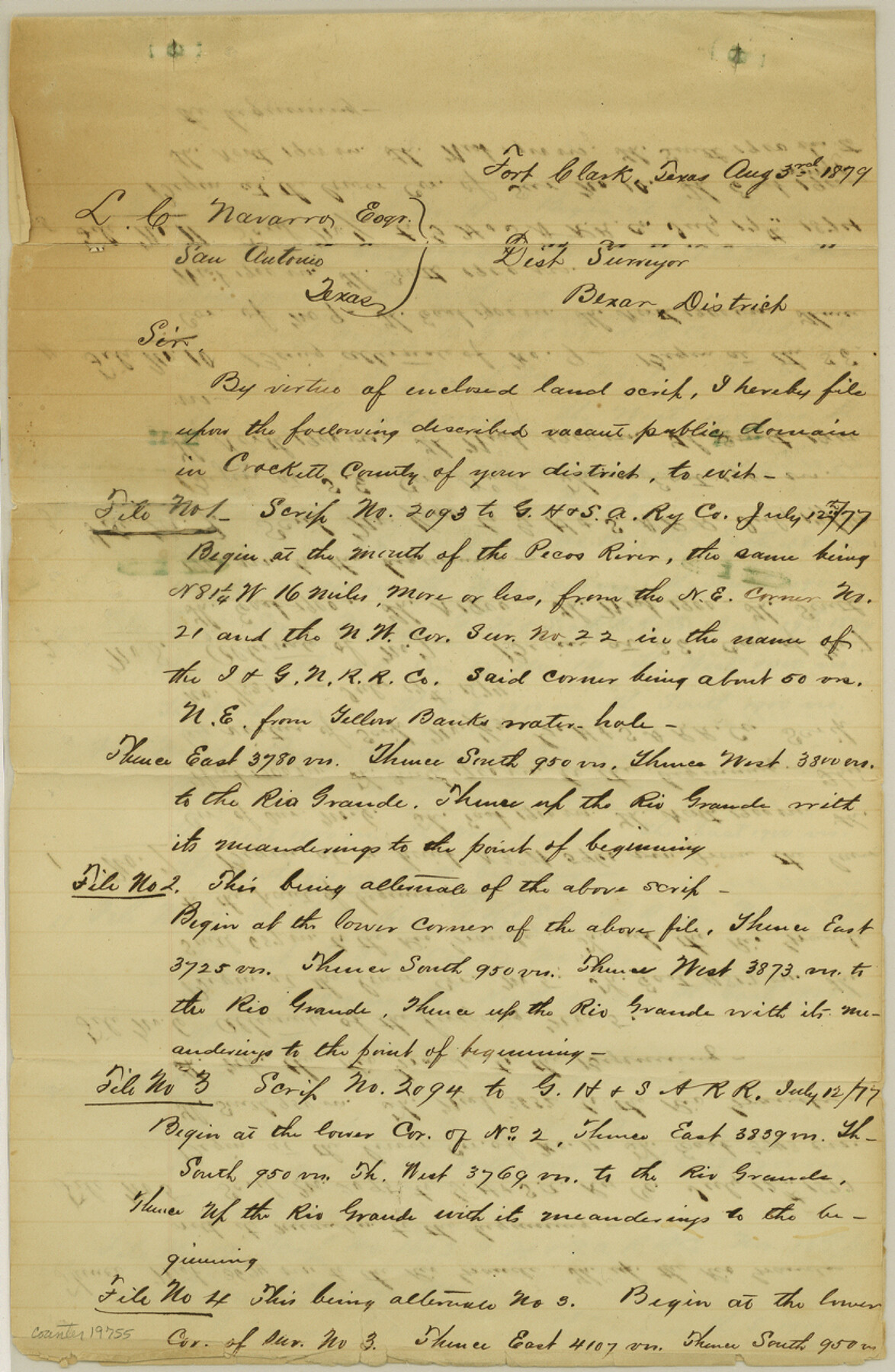
Crockett County Sketch File 42
[Application to surveyor to survey G. H. & S. A. RR. Co. certificates]
-
Map/Doc
19755
-
Collection
General Map Collection
-
Object Dates
1879/6/9 (File Date)
-
People and Organizations
Jno. L. Bullis (Surveyor/Engineer)
-
Counties
Crockett Val Verde
-
Subjects
Surveying Sketch File
-
Height x Width
12.8 x 8.4 inches
32.5 x 21.3 cm
-
Medium
paper, manuscript
-
Features
Pecos River
Geller's Banks Waterhole
Rio Grande
Devil's River
Part of: General Map Collection
Runnels County Sketch File 17

Print $6.00
Runnels County Sketch File 17
Size 11.0 x 13.6 inches
Map/Doc 35474
Hays County Working Sketch 16

Print $20.00
- Digital $50.00
Hays County Working Sketch 16
1970
Size 34.3 x 38.0 inches
Map/Doc 66090
Gillespie County Working Sketch 8

Print $20.00
- Digital $50.00
Gillespie County Working Sketch 8
1993
Size 31.1 x 24.2 inches
Map/Doc 63171
[Surveys along Elm Creek]
![347, [Surveys along Elm Creek], General Map Collection](https://historictexasmaps.com/wmedia_w700/maps/347.tif.jpg)
Print $2.00
- Digital $50.00
[Surveys along Elm Creek]
1846
Size 12.0 x 7.4 inches
Map/Doc 347
[Map of] North America
![88884, [Map of] North America, General Map Collection](https://historictexasmaps.com/wmedia_w700/maps/88884.tif.jpg)
Print $3.00
- Digital $50.00
[Map of] North America
1834
Size 11.0 x 8.5 inches
Map/Doc 88884
Guadalupe County Sketch File 3

Print $4.00
- Digital $50.00
Guadalupe County Sketch File 3
Size 8.0 x 12.6 inches
Map/Doc 24650
Bastrop County Rolled Sketch 2

Print $20.00
- Digital $50.00
Bastrop County Rolled Sketch 2
1979
Size 26.3 x 18.4 inches
Map/Doc 5123
State of Texas

Print $40.00
- Digital $50.00
State of Texas
1948
Size 44.6 x 56.8 inches
Map/Doc 78634
Panorama of the seat of war - Birds eye view of Texas and part of Mexico

Print $20.00
- Digital $50.00
Panorama of the seat of war - Birds eye view of Texas and part of Mexico
1861
Size 24.4 x 31.5 inches
Map/Doc 97250
Real County Working Sketch 61

Print $20.00
- Digital $50.00
Real County Working Sketch 61
1964
Size 37.9 x 44.5 inches
Map/Doc 71953
Map of Brazoria

Print $20.00
- Digital $50.00
Map of Brazoria
1863
Size 27.4 x 27.3 inches
Map/Doc 1013
Austin County Boundary File 4

Print $10.00
- Digital $50.00
Austin County Boundary File 4
Size 14.1 x 8.6 inches
Map/Doc 50244
You may also like
Old Miscellaneous File 39

Print $10.00
- Digital $50.00
Old Miscellaneous File 39
1893
Size 14.2 x 8.8 inches
Map/Doc 75284

Irion County Working Sketch 9

Print $20.00
- Digital $50.00
Irion County Working Sketch 9
1941
Size 13.6 x 17.2 inches
Map/Doc 66418
Hudspeth County Sketch File 42

Print $12.00
- Digital $50.00
Hudspeth County Sketch File 42
1982
Size 14.2 x 8.7 inches
Map/Doc 27016
Zavala Empresario Colony. March 12, 1829

Print $20.00
Zavala Empresario Colony. March 12, 1829
2020
Size 24.7 x 21.7 inches
Map/Doc 96012
Kinney County Working Sketch 4

Print $20.00
- Digital $50.00
Kinney County Working Sketch 4
1907
Size 21.1 x 21.6 inches
Map/Doc 70186
Crosby County Sketch File 35

Print $4.00
- Digital $50.00
Crosby County Sketch File 35
Size 8.5 x 12.1 inches
Map/Doc 20106
In the Supreme Court of the United States, The State of Oklahoma, Complainant vs. The State of Texas, Defendant, The United States of America, Intervener, Red River Valley, Texas and Oklahoma Between the 98th and 100th Meridians in Five Sheets, 1921

Print $40.00
- Digital $50.00
In the Supreme Court of the United States, The State of Oklahoma, Complainant vs. The State of Texas, Defendant, The United States of America, Intervener, Red River Valley, Texas and Oklahoma Between the 98th and 100th Meridians in Five Sheets, 1921
1921
Size 38.6 x 60.0 inches
Map/Doc 75276
Nueces County Sketch File 48

Print $20.00
- Digital $50.00
Nueces County Sketch File 48
1978
Size 14.1 x 8.5 inches
Map/Doc 32663

Clay County Boundary File 19

Print $8.00
- Digital $50.00
Clay County Boundary File 19
1924
Size 3.3 x 5.5 inches
Map/Doc 65511
Cottle County Sketch File 7

Print $20.00
- Digital $50.00
Cottle County Sketch File 7
1893
Size 22.1 x 20.7 inches
Map/Doc 11191