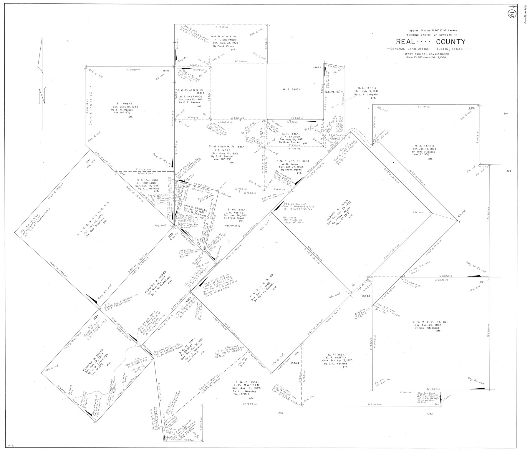
Real County Working Sketch 61
-
Map/Doc
71953
-
Collection
General Map Collection
-
Object Dates
2/19/1964 (Creation Date)
-
People and Organizations
Roy Buckholts (Draftsman)
-
Counties
Real
-
Subjects
Surveying Working Sketch
-
Height x Width
37.9 x 44.5 inches
96.3 x 113.0 cm
-
Scale
1" = 200 varas
Part of: General Map Collection
Kimble County Working Sketch 95

Print $20.00
- Digital $50.00
Kimble County Working Sketch 95
1994
Size 36.2 x 45.9 inches
Map/Doc 70163
Flight Mission No. DAG-23K, Frame 148, Matagorda County

Print $20.00
- Digital $50.00
Flight Mission No. DAG-23K, Frame 148, Matagorda County
1953
Size 18.6 x 22.4 inches
Map/Doc 86496
Lampasas County Sketch File 15

Print $20.00
- Digital $50.00
Lampasas County Sketch File 15
1888
Size 24.5 x 27.1 inches
Map/Doc 11975
Childress County

Print $20.00
- Digital $50.00
Childress County
1921
Size 44.1 x 32.2 inches
Map/Doc 4746
Flight Mission No. BRA-16M, Frame 91, Jefferson County

Print $20.00
- Digital $50.00
Flight Mission No. BRA-16M, Frame 91, Jefferson County
1953
Size 18.7 x 22.5 inches
Map/Doc 85703
Val Verde County Working Sketch 27

Print $20.00
- Digital $50.00
Val Verde County Working Sketch 27
1937
Size 26.6 x 26.4 inches
Map/Doc 72162
A map of Lewis and Clark's track across the western portion of North America from the Mississippi to the Pacific Ocean, by Order of the executive of the United States in 1804, 5, & 6

Print $20.00
- Digital $50.00
A map of Lewis and Clark's track across the western portion of North America from the Mississippi to the Pacific Ocean, by Order of the executive of the United States in 1804, 5, & 6
1814
Size 13.3 x 27.9 inches
Map/Doc 97412
Hill County Sketch File 18

Print $26.00
- Digital $50.00
Hill County Sketch File 18
1852
Size 8.6 x 4.9 inches
Map/Doc 26486
Red River County Sketch File 1

Print $4.00
- Digital $50.00
Red River County Sketch File 1
Size 8.4 x 12.8 inches
Map/Doc 35091
Aransas County Rolled Sketch 15

Print $20.00
- Digital $50.00
Aransas County Rolled Sketch 15
1889
Size 39.3 x 38.0 inches
Map/Doc 78223
Tom Green County Sketch File 53

Print $8.00
- Digital $50.00
Tom Green County Sketch File 53
1884
Size 14.2 x 9.1 inches
Map/Doc 38221
Angelina County Working Sketch 26

Print $40.00
- Digital $50.00
Angelina County Working Sketch 26
1954
Size 50.0 x 67.9 inches
Map/Doc 67108
You may also like
Liberty County Sketch File 9

Print $8.00
- Digital $50.00
Liberty County Sketch File 9
1857
Size 8.0 x 8.1 inches
Map/Doc 29900
Kimble County Working Sketch 61

Print $20.00
- Digital $50.00
Kimble County Working Sketch 61
1964
Size 23.4 x 21.5 inches
Map/Doc 70129
Jefferson County Working Sketch 21

Print $40.00
- Digital $50.00
Jefferson County Working Sketch 21
1969
Size 31.3 x 60.5 inches
Map/Doc 66564
Real County Working Sketch 25

Print $20.00
- Digital $50.00
Real County Working Sketch 25
1946
Size 26.5 x 24.7 inches
Map/Doc 71917
Archer County Boundary File 2

Print $92.00
- Digital $50.00
Archer County Boundary File 2
Size 14.4 x 8.4 inches
Map/Doc 50086
Flight Mission No. CRE-1R, Frame 133, Jackson County

Print $20.00
- Digital $50.00
Flight Mission No. CRE-1R, Frame 133, Jackson County
1956
Size 16.2 x 16.2 inches
Map/Doc 85341
Map of Texas Compiled from surveys recorded in the General Land Office

Print $20.00
Map of Texas Compiled from surveys recorded in the General Land Office
1851
Size 31.4 x 25.3 inches
Map/Doc 76209
Railroad and County Map of Texas

Print $20.00
- Digital $50.00
Railroad and County Map of Texas
1887
Size 18.0 x 23.9 inches
Map/Doc 93959
A Comprehensive Atlas Geographical, Historical & Commercial

A Comprehensive Atlas Geographical, Historical & Commercial
Size 13.0 x 10.7 inches
Map/Doc 95959


Brazoria County Rolled Sketch 18A

Print $20.00
- Digital $50.00
Brazoria County Rolled Sketch 18A
1913
Size 28.3 x 25.1 inches
Map/Doc 5164