Old Miscellaneous File 39
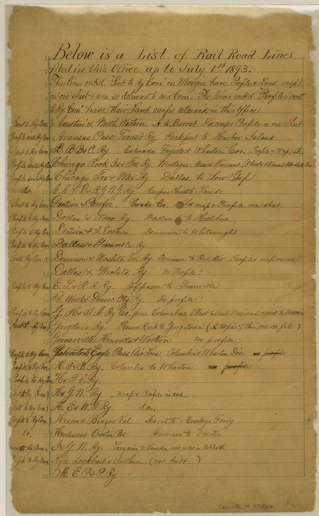
List of railroad lines filed in this office up to July 1, 1893
-
Map/Doc
75284
-
Collection
General Map Collection
-
Object Dates
1893/7/1 (Creation Date)
1893/7/1 (File Date)
-
Subjects
Railroads
-
Height x Width
14.2 x 8.8 inches
36.1 x 22.4 cm
Part of: General Map Collection
Crosby County Rolled Sketch 1

Print $20.00
- Digital $50.00
Crosby County Rolled Sketch 1
1950
Size 25.3 x 21.1 inches
Map/Doc 5640
Brewster County Working Sketch 49

Print $20.00
- Digital $50.00
Brewster County Working Sketch 49
1949
Size 37.1 x 22.6 inches
Map/Doc 67583
Map of Parker County

Print $20.00
- Digital $50.00
Map of Parker County
1879
Size 23.9 x 19.0 inches
Map/Doc 3947
Travis County Rolled Sketch 11

Print $20.00
- Digital $50.00
Travis County Rolled Sketch 11
Size 23.3 x 37.9 inches
Map/Doc 8014
Galveston County NRC Article 33.136 Sketch 26

Print $45.00
- Digital $50.00
Galveston County NRC Article 33.136 Sketch 26
2003
Size 32.6 x 24.3 inches
Map/Doc 81943
Duval County Rolled Sketch 37

Print $20.00
- Digital $50.00
Duval County Rolled Sketch 37
Size 27.1 x 17.9 inches
Map/Doc 5752

Navigation Maps of Gulf Intracoastal Waterway, Port Arthur to Brownsville, Texas

Print $4.00
- Digital $50.00
Navigation Maps of Gulf Intracoastal Waterway, Port Arthur to Brownsville, Texas
1951
Size 16.7 x 21.5 inches
Map/Doc 65441
Hutchinson County Rolled Sketch 42

Print $40.00
- Digital $50.00
Hutchinson County Rolled Sketch 42
1993
Size 38.0 x 49.5 inches
Map/Doc 6310
Map of Dallas County

Print $20.00
- Digital $50.00
Map of Dallas County
1871
Size 22.1 x 18.7 inches
Map/Doc 3463
Lipscomb County Sketch File 4

Print $56.00
- Digital $50.00
Lipscomb County Sketch File 4
1910
Size 11.2 x 8.7 inches
Map/Doc 30233
Guadalupe County Working Sketch 4

Print $20.00
- Digital $50.00
Guadalupe County Working Sketch 4
1939
Size 17.7 x 10.8 inches
Map/Doc 63313
You may also like
Flight Mission No. CGI-3N, Frame 146, Cameron County

Print $20.00
- Digital $50.00
Flight Mission No. CGI-3N, Frame 146, Cameron County
1954
Size 18.5 x 22.1 inches
Map/Doc 84619
Grimes County Sketch File 4a

Print $6.00
- Digital $50.00
Grimes County Sketch File 4a
1873
Size 13.0 x 8.4 inches
Map/Doc 24656
Howard McCauley Irrigated Farm North Half Section 2, Block D4

Print $20.00
- Digital $50.00
Howard McCauley Irrigated Farm North Half Section 2, Block D4
1946
Size 32.0 x 19.4 inches
Map/Doc 92342
Flight Mission No. BRA-16M, Frame 139, Jefferson County

Print $20.00
- Digital $50.00
Flight Mission No. BRA-16M, Frame 139, Jefferson County
1953
Size 18.6 x 22.2 inches
Map/Doc 85745
[Fractional Township No. 7 South Range No. 17 East of the Indian Meridian, Indian Territory]
![75231, [Fractional Township No. 7 South Range No. 17 East of the Indian Meridian, Indian Territory], General Map Collection](https://historictexasmaps.com/wmedia_w700/maps/75231.tif.jpg)
Print $20.00
- Digital $50.00
[Fractional Township No. 7 South Range No. 17 East of the Indian Meridian, Indian Territory]
Size 19.2 x 24.3 inches
Map/Doc 75231
Plan of the City of Galveston, Texas

Print $20.00
- Digital $50.00
Plan of the City of Galveston, Texas
1845
Size 18.3 x 27.4 inches
Map/Doc 62968
Flight Mission No. BRA-6M, Frame 84, Jefferson County

Print $20.00
- Digital $50.00
Flight Mission No. BRA-6M, Frame 84, Jefferson County
1953
Size 18.6 x 22.4 inches
Map/Doc 85428
Go Turnpike! Dallas-Fort Worth Turnpike (Verso)

Go Turnpike! Dallas-Fort Worth Turnpike (Verso)
1963
Size 11.2 x 17.2 inches
Map/Doc 94178
Garza County Plat

Print $20.00
- Digital $50.00
Garza County Plat
1948
Size 21.1 x 17.7 inches
Map/Doc 92703
[Coleman and McCullogh County Drilling Block]
![92968, [Coleman and McCullogh County Drilling Block], Twichell Survey Records](https://historictexasmaps.com/wmedia_w700/maps/92968-1.tif.jpg)
Print $20.00
- Digital $50.00
[Coleman and McCullogh County Drilling Block]
Size 16.6 x 18.6 inches
Map/Doc 92968
Runnels County Sketch File H

Print $4.00
Runnels County Sketch File H
1890
Size 14.3 x 8.8 inches
Map/Doc 35450
Bell County Sketch File 33

Print $6.00
- Digital $50.00
Bell County Sketch File 33
Size 14.4 x 8.7 inches
Map/Doc 14452