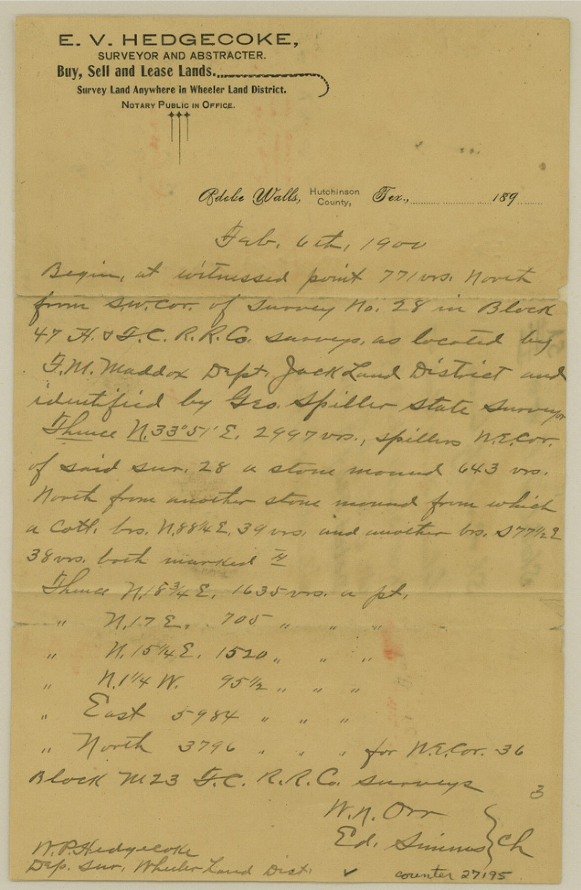
Hutchinson County Sketch File 5a
[Sketch and connecting lines between survey 28, Block 47 and survey 36, Block M23 and survey 11, Block M17]
-
Map/Doc
27195
-
Collection
General Map Collection
-
Object Dates
2/12/1900 (Creation Date)
3/28/1900 (File Date)
2/6/1900 (Correspondence Date)
2/12/1900 (Correspondence Date)
-
People and Organizations
E.V. Hedgecoke (Surveyor/Engineer)
Francis M. Maddox (Surveyor/Engineer)
George Spiller (Surveyor/Engineer)
W.N. Orr (Chainman)
Ed. Simms (Chainman)
-
Counties
Hutchinson
-
Subjects
Surveying Sketch File
-
Height x Width
9.7 x 6.4 inches
24.6 x 16.3 cm
-
Medium
paper, manuscript
Part of: General Map Collection
East Part of Houston County

Print $40.00
- Digital $50.00
East Part of Houston County
1944
Size 49.0 x 42.1 inches
Map/Doc 77316
La Salle County Sketch File 16

Print $5.00
- Digital $50.00
La Salle County Sketch File 16
1883
Size 9.3 x 9.7 inches
Map/Doc 29487
Crosby County Sketch File 32

Print $20.00
- Digital $50.00
Crosby County Sketch File 32
1938
Size 23.2 x 31.8 inches
Map/Doc 11258
Topographical Map of the City of Austin

Print $20.00
- Digital $50.00
Topographical Map of the City of Austin
1887
Size 43.1 x 41.1 inches
Map/Doc 2189
Colorado County Boundary File 2

Print $8.00
- Digital $50.00
Colorado County Boundary File 2
Size 14.3 x 8.7 inches
Map/Doc 51772
Duval County Boundary File 3

Print $14.00
- Digital $50.00
Duval County Boundary File 3
Size 8.6 x 3.9 inches
Map/Doc 52719
Flight Mission No. DAG-18K, Frame 75, Matagorda County

Print $20.00
- Digital $50.00
Flight Mission No. DAG-18K, Frame 75, Matagorda County
1952
Size 18.5 x 19.1 inches
Map/Doc 86368
Bailey County Working Sketch 5

Print $20.00
- Digital $50.00
Bailey County Working Sketch 5
1945
Size 24.3 x 18.1 inches
Map/Doc 67592
Map of Wood County

Print $20.00
- Digital $50.00
Map of Wood County
1872
Size 15.6 x 16.8 inches
Map/Doc 4167
Aransas County Rolled Sketch 1

Print $40.00
- Digital $50.00
Aransas County Rolled Sketch 1
1930
Size 16.6 x 53.4 inches
Map/Doc 8404
Childress County Rolled Sketch 8A

Print $20.00
- Digital $50.00
Childress County Rolled Sketch 8A
Size 18.2 x 12.9 inches
Map/Doc 5443

You may also like
Culberson County Sketch File 12a

Print $4.00
- Digital $50.00
Culberson County Sketch File 12a
1926
Size 14.3 x 8.8 inches
Map/Doc 20174
Flight Mission No. BQY-4M, Frame 62, Harris County

Print $20.00
- Digital $50.00
Flight Mission No. BQY-4M, Frame 62, Harris County
1953
Size 18.7 x 22.5 inches
Map/Doc 85271
[Blocks 341, G-5, G-12, TCRRCo.]
![2069, [Blocks 341, G-5, G-12, TCRRCo.], General Map Collection](https://historictexasmaps.com/wmedia_w700/maps/2069-1.tif.jpg)
Print $20.00
- Digital $50.00
[Blocks 341, G-5, G-12, TCRRCo.]
1954
Size 23.7 x 22.7 inches
Map/Doc 2069
Lavaca County Rolled Sketch 5

Print $40.00
- Digital $50.00
Lavaca County Rolled Sketch 5
Size 37.0 x 49.1 inches
Map/Doc 10288
[Missouri, Kansas & Texas Line Map through Bastrop County]
![64028, [Missouri, Kansas & Texas Line Map through Bastrop County], General Map Collection](https://historictexasmaps.com/wmedia_w700/maps/64028.tif.jpg)
Print $40.00
- Digital $50.00
[Missouri, Kansas & Texas Line Map through Bastrop County]
1916
Size 26.2 x 121.8 inches
Map/Doc 64028
The City of Austin and Suburbs

Print $20.00
The City of Austin and Suburbs
1919
Size 24.1 x 19.1 inches
Map/Doc 76203
Newton County Working Sketch 27

Print $20.00
- Digital $50.00
Newton County Working Sketch 27
1953
Size 25.9 x 30.0 inches
Map/Doc 71273
Flight Mission No. DCL-7C, Frame 37, Kenedy County

Print $20.00
- Digital $50.00
Flight Mission No. DCL-7C, Frame 37, Kenedy County
1943
Size 15.4 x 15.3 inches
Map/Doc 86025
General Highway Map, Medina County, Texas

Print $20.00
General Highway Map, Medina County, Texas
1961
Size 18.1 x 24.5 inches
Map/Doc 79593
General Highway Map, Jim Wells County, Texas

Print $20.00
General Highway Map, Jim Wells County, Texas
1961
Size 18.1 x 24.7 inches
Map/Doc 79542
General Highway Map, Dallam County, Hartley County, Texas

Print $20.00
General Highway Map, Dallam County, Hartley County, Texas
1940
Size 18.3 x 25.1 inches
Map/Doc 79065
Nueces County Rolled Sketch 74

Print $32.00
Nueces County Rolled Sketch 74
1981
Size 18.4 x 25.3 inches
Map/Doc 6932