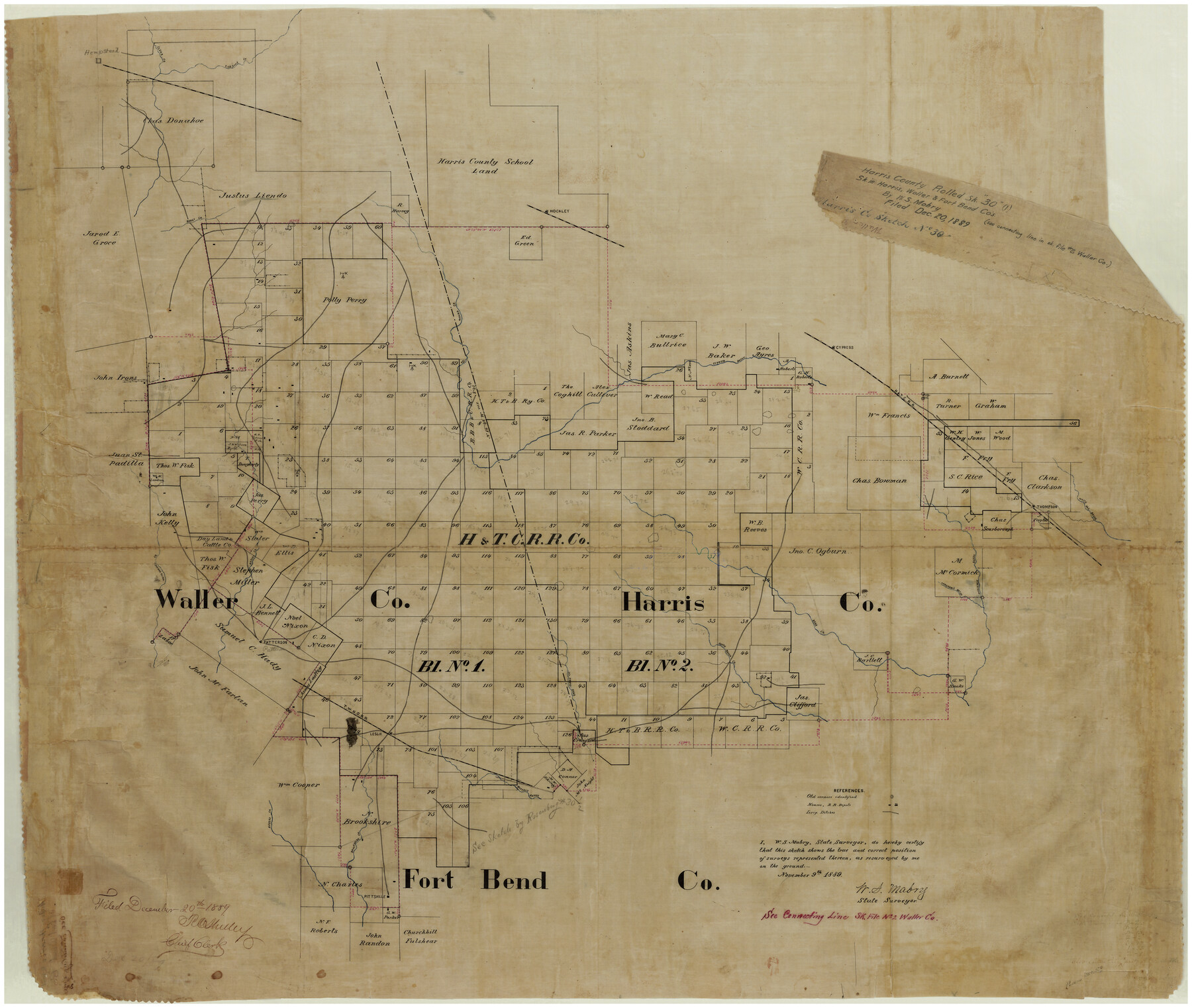
Harris County Rolled Sketch 30
[Sketch in Harris, Waller and Fort Bend Cos.]
-
Map/Doc
6096
-
Collection
General Map Collection
-
Object Dates
11/9/1889 (Creation Date)
12/20/1889 (File Date)
-
People and Organizations
W.S. Mabry (Surveyor/Engineer)
-
Counties
Harris Waller Fort Bend
-
Subjects
Surveying Rolled Sketch
-
Height x Width
30.4 x 35.1 inches
77.2 x 89.2 cm
-
Medium
paper, manuscript
-
Comments
See Waller County Sketch File 2 (39570) for connecting line.
Related maps
Waller County Sketch File 2

Print $52.00
- Digital $50.00
Waller County Sketch File 2
Size 13.3 x 9.0 inches
Map/Doc 39570
Part of: General Map Collection
Flight Mission No. DQN-1K, Frame 45, Calhoun County

Print $20.00
- Digital $50.00
Flight Mission No. DQN-1K, Frame 45, Calhoun County
1953
Size 15.8 x 15.6 inches
Map/Doc 84145
Glasscock County Rolled Sketch 8

Print $20.00
- Digital $50.00
Glasscock County Rolled Sketch 8
1951
Size 37.3 x 31.1 inches
Map/Doc 9057
Duval County Working Sketch 54

Print $20.00
- Digital $50.00
Duval County Working Sketch 54
1950
Size 14.1 x 19.8 inches
Map/Doc 68778
Sherman County Rolled Sketch 12

Print $40.00
- Digital $50.00
Sherman County Rolled Sketch 12
1951
Size 11.1 x 63.8 inches
Map/Doc 9929
Flight Mission No. CRC-1R, Frame 151, Chambers County

Print $20.00
- Digital $50.00
Flight Mission No. CRC-1R, Frame 151, Chambers County
1956
Size 18.7 x 22.4 inches
Map/Doc 84713
Presidio County Sketch File 105

Print $20.00
- Digital $50.00
Presidio County Sketch File 105
Size 13.1 x 20.6 inches
Map/Doc 82962
Angelina County Working Sketch 21

Print $20.00
- Digital $50.00
Angelina County Working Sketch 21
1947
Size 35.7 x 35.8 inches
Map/Doc 67102
Flight Mission No. BQY-4M, Frame 125, Harris County

Print $20.00
- Digital $50.00
Flight Mission No. BQY-4M, Frame 125, Harris County
1953
Size 18.6 x 22.5 inches
Map/Doc 85293
Right of Way and Track Map International & Gt Northern Ry. operated by the International & Gt. Northern Ry. Co., San Antonio Division

Print $40.00
- Digital $50.00
Right of Way and Track Map International & Gt Northern Ry. operated by the International & Gt. Northern Ry. Co., San Antonio Division
1917
Size 25.4 x 58.1 inches
Map/Doc 64787
San Jacinto County Boundary File 1a

Print $58.00
- Digital $50.00
San Jacinto County Boundary File 1a
Size 14.5 x 8.9 inches
Map/Doc 58551
Travis County Sketch File 9

Print $4.00
- Digital $50.00
Travis County Sketch File 9
Size 12.6 x 8.2 inches
Map/Doc 38290
Amistad International Reservoir on Rio Grande 79

Print $20.00
- Digital $50.00
Amistad International Reservoir on Rio Grande 79
1949
Size 28.6 x 40.3 inches
Map/Doc 75508
You may also like
Colorado County Sketch File 29

Print $6.00
- Digital $50.00
Colorado County Sketch File 29
1842
Size 11.2 x 9.0 inches
Map/Doc 18974
Flight Mission No. DQN-2K, Frame 68, Calhoun County

Print $20.00
- Digital $50.00
Flight Mission No. DQN-2K, Frame 68, Calhoun County
1953
Size 18.6 x 22.2 inches
Map/Doc 84260
Flight Mission No. DQO-3K, Frame 14, Galveston County

Print $20.00
- Digital $50.00
Flight Mission No. DQO-3K, Frame 14, Galveston County
1952
Size 18.8 x 22.4 inches
Map/Doc 85055
Flight Mission No. BQR-9K, Frame 43, Brazoria County

Print $20.00
- Digital $50.00
Flight Mission No. BQR-9K, Frame 43, Brazoria County
1952
Size 18.6 x 22.3 inches
Map/Doc 84047
Lampasas County Sketch File 8

Print $4.00
- Digital $50.00
Lampasas County Sketch File 8
1872
Size 8.8 x 7.7 inches
Map/Doc 29406
Throckmorton County Working Sketch 3

Print $20.00
- Digital $50.00
Throckmorton County Working Sketch 3
1924
Size 19.8 x 23.8 inches
Map/Doc 62112
Harris County Working Sketch 114

Print $20.00
- Digital $50.00
Harris County Working Sketch 114
1983
Size 37.6 x 29.0 inches
Map/Doc 66006
Flight Mission No. DQN-2K, Frame 134, Calhoun County

Print $20.00
- Digital $50.00
Flight Mission No. DQN-2K, Frame 134, Calhoun County
1953
Size 18.8 x 22.4 inches
Map/Doc 84303
West Part of Jeff Davis Co.

Print $20.00
- Digital $50.00
West Part of Jeff Davis Co.
1977
Size 35.0 x 45.2 inches
Map/Doc 73195
General Chart of the Coast No. XVI - Gulf Coast from Galveston to the Rio Grande

Print $20.00
- Digital $50.00
General Chart of the Coast No. XVI - Gulf Coast from Galveston to the Rio Grande
1883
Size 26.8 x 18.1 inches
Map/Doc 72737
Real County Working Sketch 78

Print $20.00
- Digital $50.00
Real County Working Sketch 78
1980
Size 33.9 x 35.5 inches
Map/Doc 71970
Jefferson County Sketch File 1

Print $2.00
- Digital $50.00
Jefferson County Sketch File 1
Size 8.8 x 7.6 inches
Map/Doc 28086