Coryell County Sketch File 7
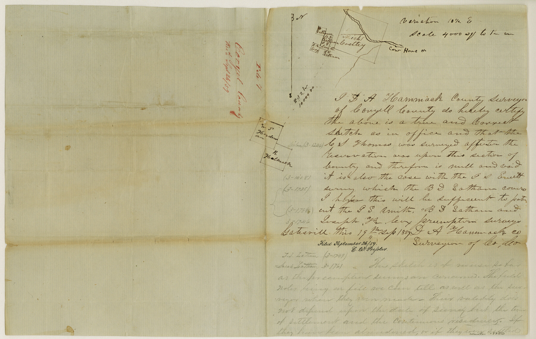
[Sketch of surveys on Cowhouse Creek]
-
Map/Doc
19349
-
Collection
General Map Collection
-
Object Dates
1859/9/19 (Creation Date)
1859/9/26 (File Date)
1858/7/29 (File Date)
-
People and Organizations
D.A. Hammack (Surveyor/Engineer)
-
Counties
Coryell
-
Subjects
Surveying Sketch File
-
Height x Width
8.3 x 12.7 inches
21.1 x 32.3 cm
-
Medium
paper, manuscript
-
Scale
1:4000
-
Features
Cow House Creek
Elm Creek
Horse Creek
Snake Creek
Part of: General Map Collection
Runnels County Working Sketch 21

Print $20.00
- Digital $50.00
Runnels County Working Sketch 21
1951
Size 43.6 x 37.0 inches
Map/Doc 63617
[Map of Connecting Lines along or near the Red River]
![75545, [Map of Connecting Lines along or near the Red River], General Map Collection](https://historictexasmaps.com/wmedia_w700/maps/75545.tif.jpg)
Print $40.00
- Digital $50.00
[Map of Connecting Lines along or near the Red River]
Size 37.9 x 48.7 inches
Map/Doc 75545
United States - Gulf Coast - Galveston to Rio Grande

Print $20.00
- Digital $50.00
United States - Gulf Coast - Galveston to Rio Grande
1941
Size 27.2 x 18.2 inches
Map/Doc 72753
[Surveys in Robertson's Colony]
![78358, [Surveys in Robertson's Colony], General Map Collection](https://historictexasmaps.com/wmedia_w700/maps/78358.tif.jpg)
Print $20.00
- Digital $50.00
[Surveys in Robertson's Colony]
Size 18.6 x 26.5 inches
Map/Doc 78358
McLennan County

Print $20.00
- Digital $50.00
McLennan County
1946
Size 42.3 x 45.1 inches
Map/Doc 77362
Hardeman County Boundary File 3a

Print $42.00
- Digital $50.00
Hardeman County Boundary File 3a
Size 56.8 x 12.3 inches
Map/Doc 54384
Donley County Boundary File 1

Print $12.00
- Digital $50.00
Donley County Boundary File 1
Size 11.1 x 8.6 inches
Map/Doc 52613
Wood County Working Sketch 15

Print $20.00
- Digital $50.00
Wood County Working Sketch 15
1981
Size 25.7 x 31.7 inches
Map/Doc 62015
Culberson County Working Sketch 72

Print $40.00
- Digital $50.00
Culberson County Working Sketch 72
1975
Size 50.1 x 34.2 inches
Map/Doc 68526
Stonewall County Working Sketch 34

Print $20.00
- Digital $50.00
Stonewall County Working Sketch 34
1985
Size 34.0 x 33.9 inches
Map/Doc 62341

Llano County Working Sketch 10

Print $20.00
- Digital $50.00
Llano County Working Sketch 10
1980
Size 21.2 x 15.1 inches
Map/Doc 70628
You may also like
Bee County Working Sketch 22

Print $20.00
- Digital $50.00
Bee County Working Sketch 22
1983
Size 37.9 x 37.2 inches
Map/Doc 67272

General Highway Map, Deaf Smith County, Texas

Print $20.00
General Highway Map, Deaf Smith County, Texas
1961
Size 25.0 x 18.3 inches
Map/Doc 79438
San Augustine County Working Sketch 27

Print $20.00
- Digital $50.00
San Augustine County Working Sketch 27
2009
Size 30.4 x 31.3 inches
Map/Doc 89020
C. C. S. D. & R. G. N. G. RR. Company, Block C2]
![90780, C. C. S. D. & R. G. N. G. RR. Company, Block C2], Twichell Survey Records](https://historictexasmaps.com/wmedia_w700/maps/90780-1.tif.jpg)
Print $20.00
- Digital $50.00
C. C. S. D. & R. G. N. G. RR. Company, Block C2]
Size 14.0 x 21.2 inches
Map/Doc 90780
Galveston County Sketch File 1a

Print $4.00
- Digital $50.00
Galveston County Sketch File 1a
1847
Size 10.2 x 8.9 inches
Map/Doc 23344
San Jacinto County Sketch File 23

Print $26.00
San Jacinto County Sketch File 23
1993
Size 14.6 x 8.8 inches
Map/Doc 35803
Atascosa County Working Sketch 31

Print $20.00
- Digital $50.00
Atascosa County Working Sketch 31
1981
Size 21.4 x 16.6 inches
Map/Doc 67227
Cottle County Sketch File 3

Print $4.00
- Digital $50.00
Cottle County Sketch File 3
Size 10.0 x 8.4 inches
Map/Doc 19457

Gaines County Sketch File 4

Print $4.00
- Digital $50.00
Gaines County Sketch File 4
1902
Size 14.3 x 8.5 inches
Map/Doc 23175
Pecos County Rolled Sketch 128A

Print $40.00
- Digital $50.00
Pecos County Rolled Sketch 128A
Size 54.5 x 45.0 inches
Map/Doc 10730