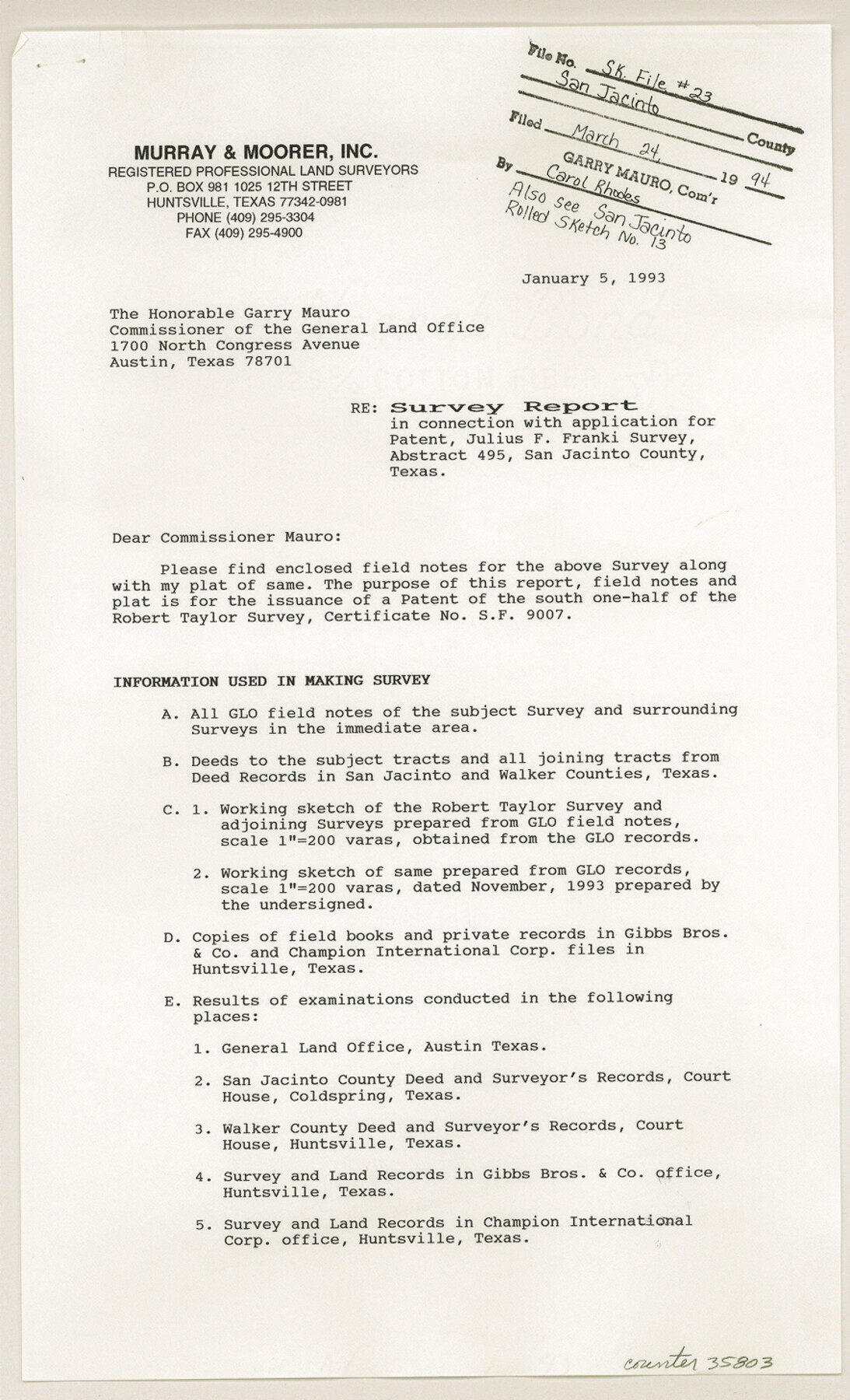
San Jacinto County Sketch File 23
Survey report in connection with application for patent, Julius F. Franki survey, abstract 495
-
Map/Doc
35803
-
Collection
General Map Collection
-
Object Dates
1/5/1993 (Creation Date)
3/24/1994 (File Date)
-
People and Organizations
Leonard E. Woods (Surveyor/Engineer)
-
Counties
San Jacinto
-
Subjects
Surveying Sketch File
-
Height x Width
14.6 x 8.8 inches
37.1 x 22.4 cm
-
Medium
paper, print
-
Comments
See San Jacinto County Rolled Sketch 13 (7562) for sketch.
-
Features
Mill Creek
Riverside to Staley Road
Related maps
San Jacinto County Rolled Sketch 13

Print $20.00
- Digital $50.00
San Jacinto County Rolled Sketch 13
1994
Size 32.2 x 23.7 inches
Map/Doc 7562
Part of: General Map Collection
Nueces County Rolled Sketch 7

Print $20.00
- Digital $50.00
Nueces County Rolled Sketch 7
Size 37.5 x 34.6 inches
Map/Doc 9585

Nueces County Rolled Sketch 113A

Print $20.00
- Digital $50.00
Nueces County Rolled Sketch 113A
1972
Size 19.1 x 24.4 inches
Map/Doc 7121
Bandera County Working Sketch 18

Print $20.00
- Digital $50.00
Bandera County Working Sketch 18
1946
Size 25.6 x 26.5 inches
Map/Doc 67614
Hudspeth County Rolled Sketch 28

Print $40.00
- Digital $50.00
Hudspeth County Rolled Sketch 28
Size 31.5 x 49.8 inches
Map/Doc 9208
Jack County Rolled Sketch 3

Print $20.00
- Digital $50.00
Jack County Rolled Sketch 3
1985
Size 30.3 x 27.5 inches
Map/Doc 6333
Padre Island National Seashore

Print $4.00
- Digital $50.00
Padre Island National Seashore
Size 16.0 x 22.0 inches
Map/Doc 60529
Denton County Boundary File 4 and 4a and 4b and 4c

Print $168.00
- Digital $50.00
Denton County Boundary File 4 and 4a and 4b and 4c
Size 11.1 x 8.6 inches
Map/Doc 52448
Copy of Surveyor's Field Book, Morris Browning - In Blocks 7, 5 & 4, I&GNRRCo., Hutchinson and Carson Counties, Texas

Print $2.00
- Digital $50.00
Copy of Surveyor's Field Book, Morris Browning - In Blocks 7, 5 & 4, I&GNRRCo., Hutchinson and Carson Counties, Texas
1888
Size 6.8 x 8.8 inches
Map/Doc 62274
Encinal County

Print $20.00
- Digital $50.00
Encinal County
1895
Size 34.4 x 24.0 inches
Map/Doc 3516
Wise County Sketch File 27

Print $4.00
- Digital $50.00
Wise County Sketch File 27
1857
Size 12.4 x 8.2 inches
Map/Doc 40576

You may also like
Refugio County Aerial Photograph Index Sheet 5

Print $20.00
- Digital $50.00
Refugio County Aerial Photograph Index Sheet 5
1957
Size 23.2 x 18.9 inches
Map/Doc 83743
Jim Hogg County Working Sketch 10

Print $20.00
- Digital $50.00
Jim Hogg County Working Sketch 10
Size 18.8 x 15.6 inches
Map/Doc 66596
Bell County Working Sketch 13

Print $20.00
- Digital $50.00
Bell County Working Sketch 13
1964
Size 19.6 x 18.5 inches
Map/Doc 67353
Maps of Gulf Intracoastal Waterway, Texas - Sabine River to the Rio Grande and connecting waterways including ship channels

Print $20.00
- Digital $50.00
Maps of Gulf Intracoastal Waterway, Texas - Sabine River to the Rio Grande and connecting waterways including ship channels
1966
Size 14.5 x 22.2 inches
Map/Doc 61937
McMullen County Sketch File 19

Print $4.00
- Digital $50.00
McMullen County Sketch File 19
Size 12.8 x 8.1 inches
Map/Doc 31371
Brewster County Rolled Sketch 153

Print $20.00
- Digital $50.00
Brewster County Rolled Sketch 153
Size 32.4 x 19.2 inches
Map/Doc 5320
Flight Mission No. CLL-1N, Frame 195, Willacy County

Print $20.00
- Digital $50.00
Flight Mission No. CLL-1N, Frame 195, Willacy County
1954
Size 18.5 x 22.3 inches
Map/Doc 87065

Galveston County Sketch File 28

Print $42.00
- Digital $50.00
Galveston County Sketch File 28
1913
Size 22.2 x 5.4 inches
Map/Doc 23410
Sterling County Working Sketch 1

Print $20.00
- Digital $50.00
Sterling County Working Sketch 1
1926
Size 30.3 x 29.6 inches
Map/Doc 63983
Tyler County Working Sketch 25

Print $20.00
- Digital $50.00
Tyler County Working Sketch 25
1909
Size 29.8 x 26.7 inches
Map/Doc 69495
