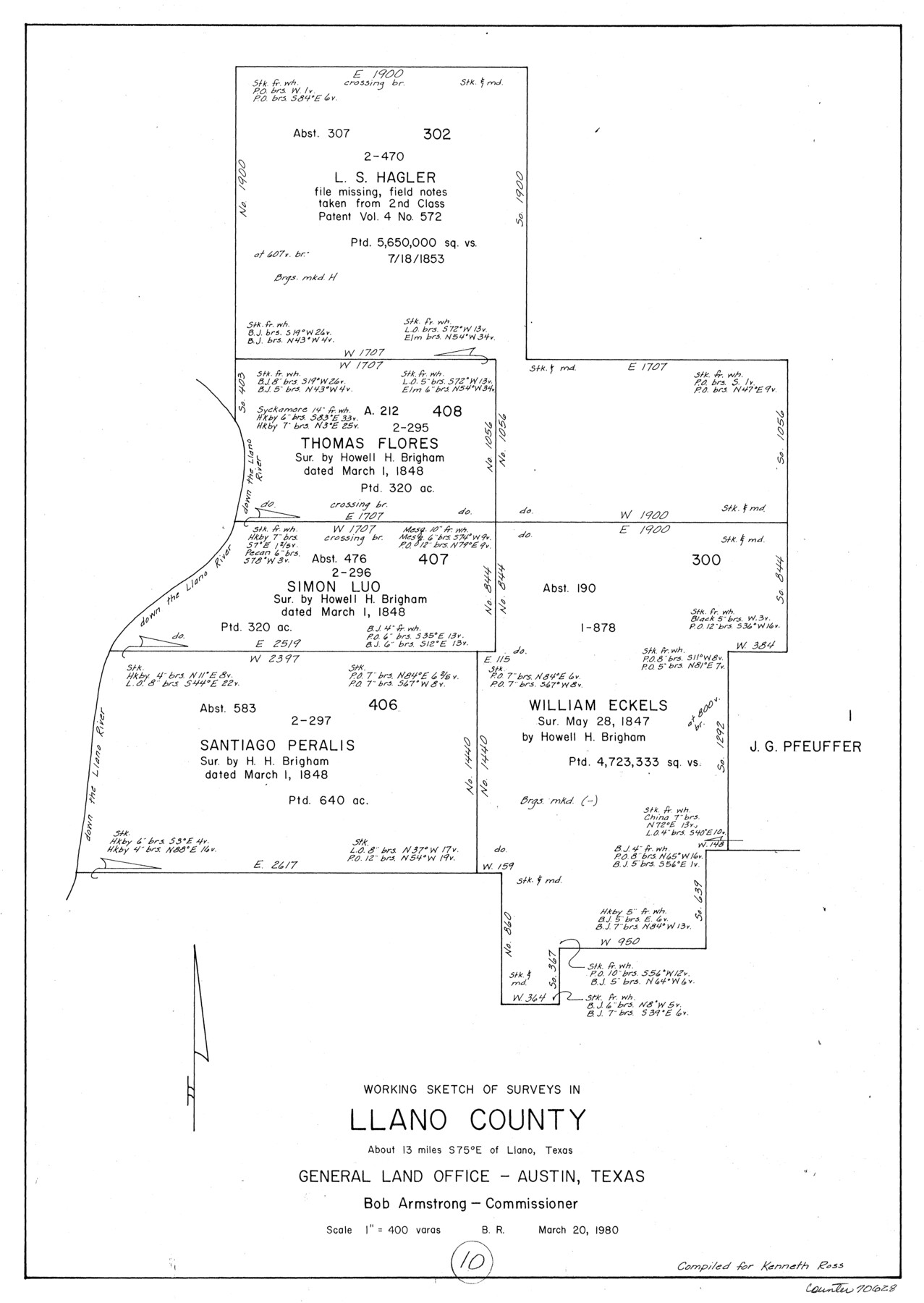
Llano County Working Sketch 10
-
Map/Doc
70628
-
Collection
General Map Collection
-
Object Dates
3/20/1980 (Creation Date)
-
People and Organizations
Beverly Robison (Draftsman)
-
Counties
Llano
-
Subjects
Surveying Working Sketch
-
Height x Width
21.2 x 15.1 inches
53.9 x 38.4 cm
-
Scale
1" = 400 varas
Part of: General Map Collection
Current Miscellaneous File 28

Print $22.00
- Digital $50.00
Current Miscellaneous File 28
1952
Size 10.7 x 16.3 inches
Map/Doc 73911
Cameron County NRC Article 33.136 Sketch 5

Print $202.00
- Digital $50.00
Cameron County NRC Article 33.136 Sketch 5
2018
Size 24.3 x 36.1 inches
Map/Doc 95724
Uvalde County Rolled Sketch 11

Print $20.00
- Digital $50.00
Uvalde County Rolled Sketch 11
1966
Size 28.1 x 27.8 inches
Map/Doc 8096
Railroad Track Map, H&TCRRCo., Falls County, Texas

Print $4.00
- Digital $50.00
Railroad Track Map, H&TCRRCo., Falls County, Texas
1918
Size 11.5 x 18.4 inches
Map/Doc 62846
Brazos River, Brazos River Sheet 2

Print $20.00
- Digital $50.00
Brazos River, Brazos River Sheet 2
1926
Size 22.3 x 29.4 inches
Map/Doc 69666
Jefferson County Rolled Sketch 4

Print $40.00
- Digital $50.00
Jefferson County Rolled Sketch 4
Size 36.7 x 65.3 inches
Map/Doc 9269
Presidio County Rolled Sketch T-1

Print $20.00
- Digital $50.00
Presidio County Rolled Sketch T-1
Size 26.8 x 27.1 inches
Map/Doc 7416
Aransas County Sketch File 3

Print $4.00
- Digital $50.00
Aransas County Sketch File 3
Size 8.0 x 12.7 inches
Map/Doc 13104
Flight Mission No. CUG-1P, Frame 53, Kleberg County

Print $20.00
- Digital $50.00
Flight Mission No. CUG-1P, Frame 53, Kleberg County
1956
Size 18.6 x 22.4 inches
Map/Doc 86131
McCulloch County Sketch File 10

Print $8.00
- Digital $50.00
McCulloch County Sketch File 10
1920
Size 11.1 x 8.7 inches
Map/Doc 31187
Kimble County Sketch File A

Print $20.00
- Digital $50.00
Kimble County Sketch File A
1895
Size 17.9 x 18.7 inches
Map/Doc 11933
Pecos County Working Sketch 44

Print $20.00
- Digital $50.00
Pecos County Working Sketch 44
1945
Size 29.6 x 35.0 inches
Map/Doc 71516
You may also like
Flight Mission No. DAG-17K, Frame 123, Matagorda County

Print $20.00
- Digital $50.00
Flight Mission No. DAG-17K, Frame 123, Matagorda County
1952
Size 18.6 x 22.3 inches
Map/Doc 86343
Dallas County Working Sketch Graphic Index

Print $20.00
- Digital $50.00
Dallas County Working Sketch Graphic Index
1942
Size 43.9 x 36.7 inches
Map/Doc 76517
Haskell County Rolled Sketch 10

Print $20.00
- Digital $50.00
Haskell County Rolled Sketch 10
1981
Size 33.2 x 14.3 inches
Map/Doc 6169
[In Northwest 1/4 of County in the vicinity of the John Walker Survey]
![90910, [In Northwest 1/4 of County in the vicinity of the John Walker Survey], Twichell Survey Records](https://historictexasmaps.com/wmedia_w700/maps/90910-1.tif.jpg)
Print $20.00
- Digital $50.00
[In Northwest 1/4 of County in the vicinity of the John Walker Survey]
Size 15.2 x 23.9 inches
Map/Doc 90910
Erath County Working Sketch 8

Print $20.00
- Digital $50.00
Erath County Working Sketch 8
1936
Size 16.0 x 16.2 inches
Map/Doc 69089
Lee County Working Sketch 7

Print $20.00
- Digital $50.00
Lee County Working Sketch 7
1977
Size 27.0 x 16.8 inches
Map/Doc 70386

Flight Mission No. BQR-20K, Frame 6, Brazoria County

Print $20.00
- Digital $50.00
Flight Mission No. BQR-20K, Frame 6, Brazoria County
1952
Size 18.6 x 22.3 inches
Map/Doc 84108

Flight Mission No. BRA-8M, Frame 73, Jefferson County

Print $20.00
- Digital $50.00
Flight Mission No. BRA-8M, Frame 73, Jefferson County
1953
Size 18.7 x 22.3 inches
Map/Doc 85593
Real County Working Sketch 80

Print $20.00
- Digital $50.00
Real County Working Sketch 80
1984
Size 37.9 x 43.3 inches
Map/Doc 71972
Sutton County Sketch File 37

Print $20.00
- Digital $50.00
Sutton County Sketch File 37
Size 19.7 x 19.7 inches
Map/Doc 12387