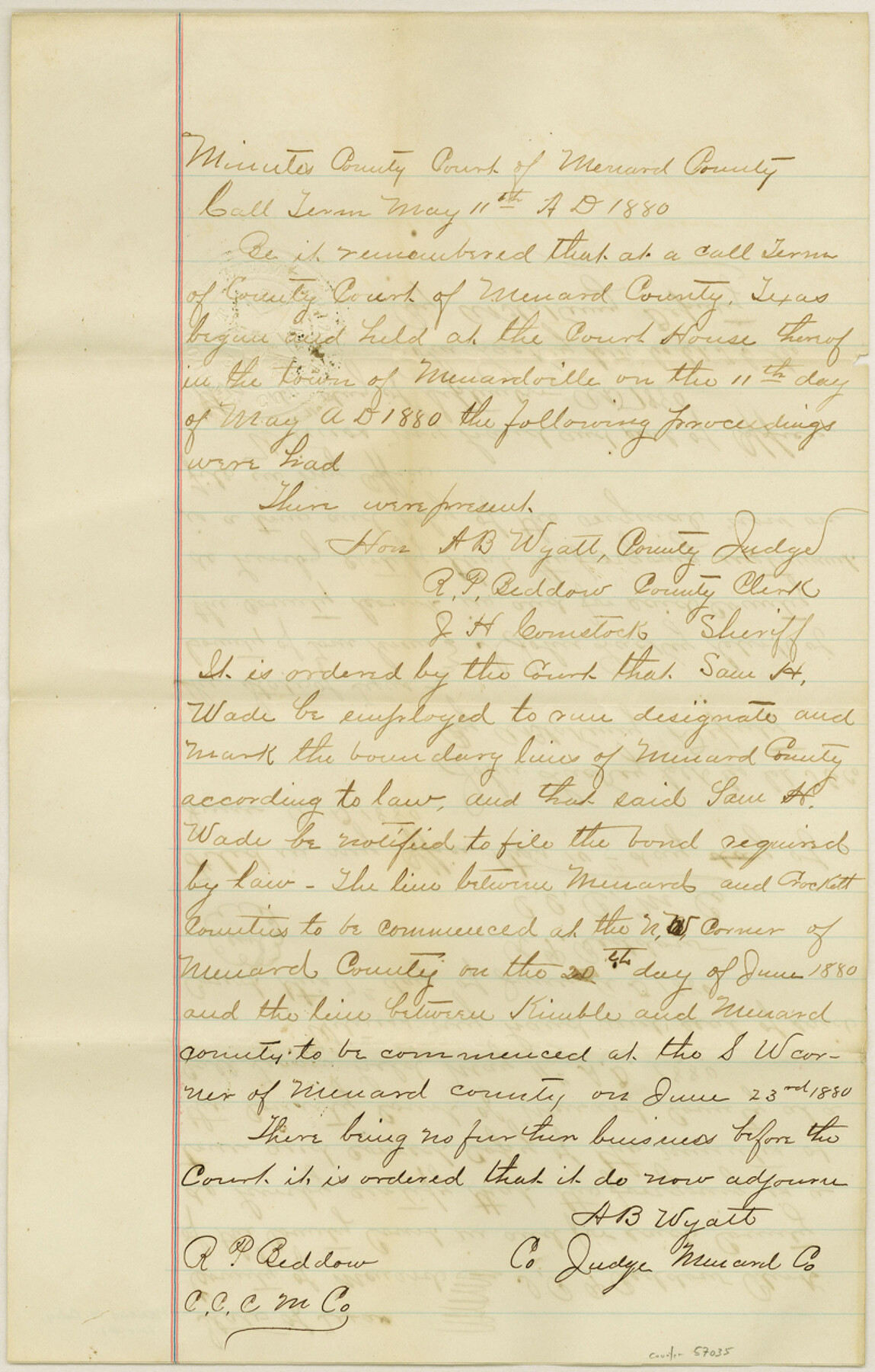
Menard County Boundary File 1
Certified Copy of the Order of Menard Co. Clerk; Certified Copy of Order Appt. C. D. Foote Surveyor
-
Map/Doc
57035
-
Collection
General Map Collection
-
Counties
Menard
-
Subjects
County Boundaries
-
Height x Width
12.7 x 8.1 inches
32.3 x 20.6 cm
Part of: General Map Collection
Edwards County Sketch File 28

Print $5.00
- Digital $50.00
Edwards County Sketch File 28
Size 27.3 x 25.6 inches
Map/Doc 11431
Fannin County Working Sketch Graphic Index

Print $20.00
- Digital $50.00
Fannin County Working Sketch Graphic Index
1946
Size 41.3 x 36.2 inches
Map/Doc 76540
[Atlas A, Table of Contents, part 2]
![82085, [Atlas A, Table of Contents, part 2], General Map Collection](https://historictexasmaps.com/wmedia_w700/maps/82085.tif.jpg)
Print $2.00
- Digital $50.00
[Atlas A, Table of Contents, part 2]
Size 7.0 x 11.8 inches
Map/Doc 82085
Map of Leon County

Print $40.00
- Digital $50.00
Map of Leon County
Size 49.7 x 42.0 inches
Map/Doc 66900
Kent County Rolled Sketch 5

Print $20.00
- Digital $50.00
Kent County Rolled Sketch 5
1951
Size 43.7 x 36.9 inches
Map/Doc 78522
Rio Grande Rectification Project, El Paso and Juarez Valley

Print $20.00
- Digital $50.00
Rio Grande Rectification Project, El Paso and Juarez Valley
1935
Size 10.7 x 29.4 inches
Map/Doc 60867
Victoria County Rolled Sketch 4A

Print $40.00
- Digital $50.00
Victoria County Rolled Sketch 4A
Size 66.4 x 43.9 inches
Map/Doc 10095
Crockett County Rolled Sketch 88B

Print $20.00
- Digital $50.00
Crockett County Rolled Sketch 88B
1973
Size 35.1 x 38.9 inches
Map/Doc 8727
Jefferson County Rolled Sketch 49

Print $40.00
- Digital $50.00
Jefferson County Rolled Sketch 49
1963
Size 30.6 x 57.5 inches
Map/Doc 46415
Freestone County Rolled Sketch 1

Print $20.00
- Digital $50.00
Freestone County Rolled Sketch 1
1947
Size 28.1 x 26.0 inches
Map/Doc 5909
Flight Mission No. DCL-4C, Frame 146, Kenedy County

Print $20.00
- Digital $50.00
Flight Mission No. DCL-4C, Frame 146, Kenedy County
1943
Size 18.6 x 22.3 inches
Map/Doc 85824
Wise County Rolled Sketch 2

Print $40.00
- Digital $50.00
Wise County Rolled Sketch 2
1941
Size 58.7 x 44.8 inches
Map/Doc 10155
You may also like
Flight Mission No. DIX-6P, Frame 189, Aransas County

Print $20.00
- Digital $50.00
Flight Mission No. DIX-6P, Frame 189, Aransas County
1956
Size 19.1 x 22.8 inches
Map/Doc 83851
King County Sketch File 5

Print $6.00
- Digital $50.00
King County Sketch File 5
1895
Size 10.6 x 12.2 inches
Map/Doc 29024
Fort Bend County Working Sketch 8

Print $20.00
- Digital $50.00
Fort Bend County Working Sketch 8
1922
Size 24.9 x 17.6 inches
Map/Doc 69214
Young County Sketch File 22

Print $20.00
- Digital $50.00
Young County Sketch File 22
1957
Size 22.9 x 19.8 inches
Map/Doc 12716
Flight Mission No. DIX-10P, Frame 67, Aransas County

Print $20.00
- Digital $50.00
Flight Mission No. DIX-10P, Frame 67, Aransas County
1956
Size 18.7 x 22.3 inches
Map/Doc 83928
Prison Property, Walker County

Print $20.00
- Digital $50.00
Prison Property, Walker County
Size 16.3 x 15.9 inches
Map/Doc 94280
Brewster County Sketch File NS-3

Print $40.00
- Digital $50.00
Brewster County Sketch File NS-3
1913
Size 30.9 x 15.6 inches
Map/Doc 10986
United States - Gulf Coast - Galveston to Rio Grande

Print $20.00
- Digital $50.00
United States - Gulf Coast - Galveston to Rio Grande
1919
Size 27.1 x 18.3 inches
Map/Doc 72749
Cass County Sketch File 9

Print $4.00
- Digital $50.00
Cass County Sketch File 9
1857
Size 8.0 x 13.1 inches
Map/Doc 17410
[Surveys in the Bexar District along the Medina River west of the San Antonio River]
![57, [Surveys in the Bexar District along the Medina River west of the San Antonio River], General Map Collection](https://historictexasmaps.com/wmedia_w700/maps/57.tif.jpg)
Print $2.00
- Digital $50.00
[Surveys in the Bexar District along the Medina River west of the San Antonio River]
1842
Size 8.0 x 15.2 inches
Map/Doc 57
Trinity County Rolled Sketch 5

Print $20.00
- Digital $50.00
Trinity County Rolled Sketch 5
1993
Size 25.3 x 38.0 inches
Map/Doc 8052
Jefferson County Aerial Photograph Index Sheet 8

Print $20.00
- Digital $50.00
Jefferson County Aerial Photograph Index Sheet 8
1953
Size 23.4 x 17.0 inches
Map/Doc 83712