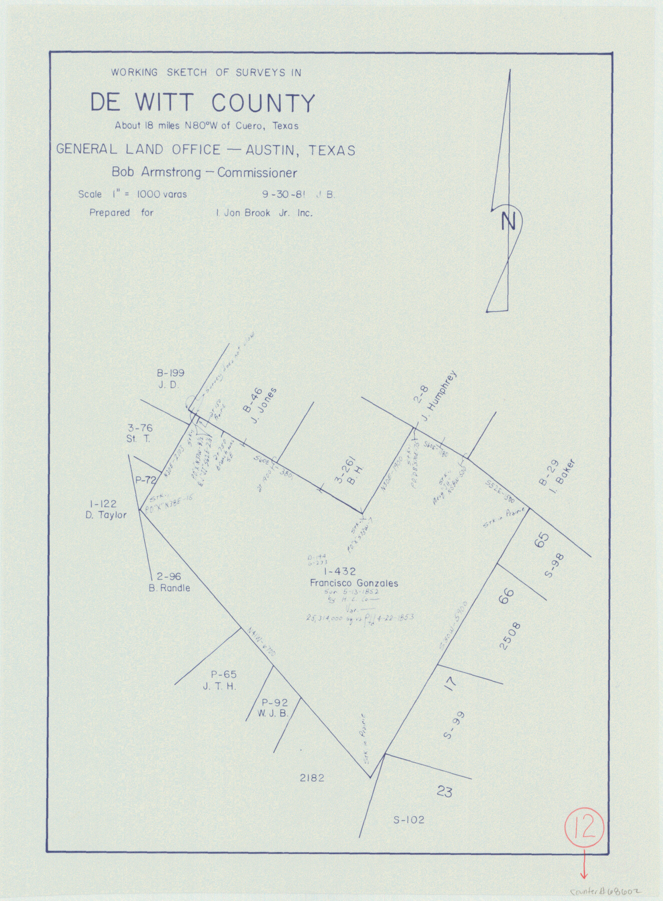
DeWitt County Working Sketch 12
-
Map/Doc
68602
-
Collection
General Map Collection
-
Object Dates
9/30/1981 (Creation Date)
-
People and Organizations
Jana Brod (Draftsman)
-
Counties
DeWitt
-
Subjects
Surveying Working Sketch
-
Height x Width
17.0 x 12.5 inches
43.2 x 31.8 cm
-
Scale
1" = 1000 varas
Part of: General Map Collection
El Paso County Rolled Sketch 52

Print $20.00
- Digital $50.00
El Paso County Rolled Sketch 52
1929
Size 18.4 x 24.4 inches
Map/Doc 5844
Northwest Part Crockett County

Print $40.00
- Digital $50.00
Northwest Part Crockett County
1983
Size 38.1 x 48.8 inches
Map/Doc 73121
San Patricio County Rolled Sketch 29B

Print $20.00
- Digital $50.00
San Patricio County Rolled Sketch 29B
1936
Size 25.8 x 31.0 inches
Map/Doc 7582
[San Antonio & Aransas Pass]
![64208, [San Antonio & Aransas Pass], General Map Collection](https://historictexasmaps.com/wmedia_w700/maps/64208.tif.jpg)
Print $40.00
- Digital $50.00
[San Antonio & Aransas Pass]
Size 17.0 x 50.7 inches
Map/Doc 64208
Flight Mission No. BRA-9M, Frame 70, Jefferson County

Print $20.00
- Digital $50.00
Flight Mission No. BRA-9M, Frame 70, Jefferson County
1953
Size 18.6 x 22.5 inches
Map/Doc 85653
Johnson County Working Sketch 2

Print $20.00
- Digital $50.00
Johnson County Working Sketch 2
Size 20.8 x 20.2 inches
Map/Doc 66615
Rusk County Working Sketch 2

Print $40.00
- Digital $50.00
Rusk County Working Sketch 2
Size 36.4 x 58.2 inches
Map/Doc 63637
Henderson County

Print $40.00
- Digital $50.00
Henderson County
1988
Size 30.8 x 63.0 inches
Map/Doc 77310
Atascosa County Sketch File 34

Print $4.00
- Digital $50.00
Atascosa County Sketch File 34
Size 10.4 x 8.3 inches
Map/Doc 13827
Matagorda Bay Including Lavaca and Tres Palacios Bays

Print $20.00
- Digital $50.00
Matagorda Bay Including Lavaca and Tres Palacios Bays
1975
Size 37.2 x 47.7 inches
Map/Doc 73364
Brazos River, Darrington-Ramsey Farms Project

Print $20.00
- Digital $50.00
Brazos River, Darrington-Ramsey Farms Project
1930
Size 37.5 x 26.8 inches
Map/Doc 69677
Flight Mission No. DIX-6P, Frame 190, Aransas County

Print $20.00
- Digital $50.00
Flight Mission No. DIX-6P, Frame 190, Aransas County
1956
Size 18.8 x 22.7 inches
Map/Doc 83852
You may also like
Edwards County Working Sketch 56

Print $20.00
- Digital $50.00
Edwards County Working Sketch 56
1952
Size 23.6 x 35.7 inches
Map/Doc 68932
Crane County Rolled Sketch 26

Print $20.00
- Digital $50.00
Crane County Rolled Sketch 26
2020
Size 36.5 x 24.5 inches
Map/Doc 96432
Flight Mission No. BRE-3P, Frame 34, Nueces County

Print $20.00
- Digital $50.00
Flight Mission No. BRE-3P, Frame 34, Nueces County
1956
Size 18.5 x 22.3 inches
Map/Doc 86812
Flight Mission No. DQO-3K, Frame 81, Galveston County

Print $20.00
- Digital $50.00
Flight Mission No. DQO-3K, Frame 81, Galveston County
1952
Size 18.7 x 22.5 inches
Map/Doc 85086
Cameron County Rolled Sketch 22

Print $63.00
- Digital $50.00
Cameron County Rolled Sketch 22
Size 9.8 x 15.0 inches
Map/Doc 43919
Sutton County Rolled Sketch 69

Print $20.00
- Digital $50.00
Sutton County Rolled Sketch 69
Size 39.7 x 36.6 inches
Map/Doc 9981
Nueces County Rolled Sketch 124

Print $20.00
- Digital $50.00
Nueces County Rolled Sketch 124
1997
Size 23.7 x 36.8 inches
Map/Doc 7159
Navigation Maps of Gulf Intracoastal Waterway, Port Arthur to Brownsville, Texas

Print $4.00
- Digital $50.00
Navigation Maps of Gulf Intracoastal Waterway, Port Arthur to Brownsville, Texas
1951
Size 16.6 x 21.5 inches
Map/Doc 65440
Orange County Boundary File 8

Print $4.00
- Digital $50.00
Orange County Boundary File 8
Size 11.9 x 7.6 inches
Map/Doc 57780
Flight Mission No. BQR-22K, Frame 43, Brazoria County

Print $20.00
- Digital $50.00
Flight Mission No. BQR-22K, Frame 43, Brazoria County
1953
Size 18.6 x 22.3 inches
Map/Doc 84127
Val Verde County

Print $20.00
- Digital $50.00
Val Verde County
1944
Size 41.3 x 36.6 inches
Map/Doc 95661
Lubbock County Rolled Sketch 3

Print $20.00
- Digital $50.00
Lubbock County Rolled Sketch 3
Size 25.0 x 38.7 inches
Map/Doc 9469