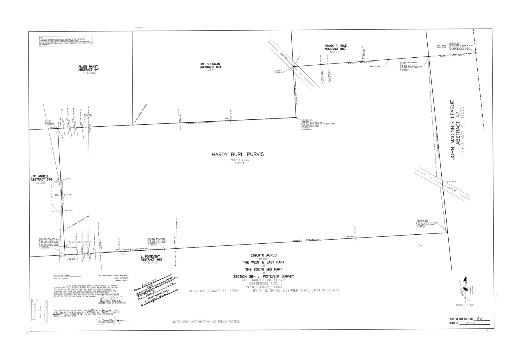
Polk County Rolled Sketch 33
269.610 acres being the west & east part of the south mid part of section 38 - J. Poitevent survey for Hardy Burl Purvis certificate 1/51, Polk County, Texas
-
Map/Doc
7319
-
Collection
General Map Collection
-
Object Dates
1994/8/22 (Survey Date)
1994/8/27 (File Date)
-
People and Organizations
D.D. Shine (Surveyor/Engineer)
David Wheeler (Chainman/Field Personnel)
Alan Chambliss (Chainman/Field Personnel)
Carmen Anaya (Chainman/Field Personnel)
-
Counties
Polk
-
Subjects
Surveying Rolled Sketch
-
Height x Width
26.5 x 38.5 inches
67.3 x 97.8 cm
-
Medium
mylar, print
-
Scale
1" = 200 feet
-
Comments
See Polk County Sketch File 45 (34376) for report.
Related maps
Polk County Sketch File 45

Print $4.00
- Digital $50.00
Polk County Sketch File 45
Size 11.3 x 8.8 inches
Map/Doc 34376
Part of: General Map Collection
Flight Mission No. BRA-7M, Frame 208, Jefferson County

Print $20.00
- Digital $50.00
Flight Mission No. BRA-7M, Frame 208, Jefferson County
1953
Size 18.5 x 22.3 inches
Map/Doc 85576
Zapata County Working Sketch 16

Print $20.00
- Digital $50.00
Zapata County Working Sketch 16
1969
Size 26.1 x 28.3 inches
Map/Doc 62067
Origin of Imports and Destination of Exports at Texas City, Tex., during 1921

Print $20.00
- Digital $50.00
Origin of Imports and Destination of Exports at Texas City, Tex., during 1921
1921
Size 13.4 x 24.9 inches
Map/Doc 97163
Ochiltree County

Print $20.00
- Digital $50.00
Ochiltree County
1878
Size 19.2 x 17.5 inches
Map/Doc 3924
Wharton County

Print $40.00
- Digital $50.00
Wharton County
1894
Size 52.3 x 56.3 inches
Map/Doc 16923
Real County Rolled Sketch 20

Print $20.00
- Digital $50.00
Real County Rolled Sketch 20
2004
Size 24.6 x 35.8 inches
Map/Doc 82573
Galveston County Working Sketch 7

Print $20.00
- Digital $50.00
Galveston County Working Sketch 7
1936
Size 18.0 x 20.6 inches
Map/Doc 69344
Right of Way and Track Map Houston & Texas Central R.R. operated by the T. and N. O. R.R. Co., Fort Worth Branch

Print $40.00
- Digital $50.00
Right of Way and Track Map Houston & Texas Central R.R. operated by the T. and N. O. R.R. Co., Fort Worth Branch
1918
Size 31.1 x 57.4 inches
Map/Doc 64540
Menard County Sketch File 10

Print $20.00
- Digital $50.00
Menard County Sketch File 10
1885
Size 32.5 x 18.0 inches
Map/Doc 12074
Nautical Chart 887-SC Intracoastal Waterway - Galveston Bay to Cedar Lakes including the Brazos and San Bernard Rivers, Texas

Print $40.00
- Digital $50.00
Nautical Chart 887-SC Intracoastal Waterway - Galveston Bay to Cedar Lakes including the Brazos and San Bernard Rivers, Texas
1971
Size 15.3 x 59.6 inches
Map/Doc 69939
Cameron County Sketch File 10

Print $8.00
- Digital $50.00
Cameron County Sketch File 10
1989
Size 11.1 x 8.6 inches
Map/Doc 17205
Flight Mission No. DCL-7C, Frame 144, Kenedy County

Print $20.00
- Digital $50.00
Flight Mission No. DCL-7C, Frame 144, Kenedy County
1943
Size 18.6 x 22.5 inches
Map/Doc 86101
You may also like
Map of City of Brownfield, Texas

Print $20.00
- Digital $50.00
Map of City of Brownfield, Texas
1953
Size 44.4 x 40.1 inches
Map/Doc 89890
Nueces County Sketch File 7

Print $7.00
- Digital $50.00
Nueces County Sketch File 7
1849
Size 11.3 x 9.3 inches
Map/Doc 32509
Hays County Sketch File 35

Print $4.00
- Digital $50.00
Hays County Sketch File 35
1873
Size 12.8 x 8.2 inches
Map/Doc 26277
[Working Sketch of a portion of Hidalgo & Starr Co's.]
![4447, [Working Sketch of a portion of Hidalgo & Starr Co's.], Maddox Collection](https://historictexasmaps.com/wmedia_w700/maps/4447.tif.jpg)
Print $20.00
- Digital $50.00
[Working Sketch of a portion of Hidalgo & Starr Co's.]
1906
Size 27.8 x 13.8 inches
Map/Doc 4447
Terrell County Rolled Sketch 52

Print $20.00
- Digital $50.00
Terrell County Rolled Sketch 52
1967
Size 26.8 x 30.5 inches
Map/Doc 7970
Right of Way & Track Map, San Antonio & Aransas Pass Railway Co.

Print $40.00
- Digital $50.00
Right of Way & Track Map, San Antonio & Aransas Pass Railway Co.
1919
Size 25.3 x 56.6 inches
Map/Doc 64214
Section 8, Block B

Print $20.00
- Digital $50.00
Section 8, Block B
1951
Size 24.8 x 16.8 inches
Map/Doc 92275

Mason County, Texas

Print $20.00
- Digital $50.00
Mason County, Texas
1896
Size 34.6 x 32.8 inches
Map/Doc 392
Atascosa County Boundary File 4

Print $80.00
- Digital $50.00
Atascosa County Boundary File 4
Size 30.6 x 59.2 inches
Map/Doc 50177
[San Antonio & Aransas Pass Railway Co.]
![64260, [San Antonio & Aransas Pass Railway Co.], General Map Collection](https://historictexasmaps.com/wmedia_w700/maps/64260.tif.jpg)
Print $20.00
- Digital $50.00
[San Antonio & Aransas Pass Railway Co.]
Size 18.5 x 29.4 inches
Map/Doc 64260
Roberts County, State of Texas

Print $20.00
Roberts County, State of Texas
1888
Size 21.6 x 16.4 inches
Map/Doc 88990