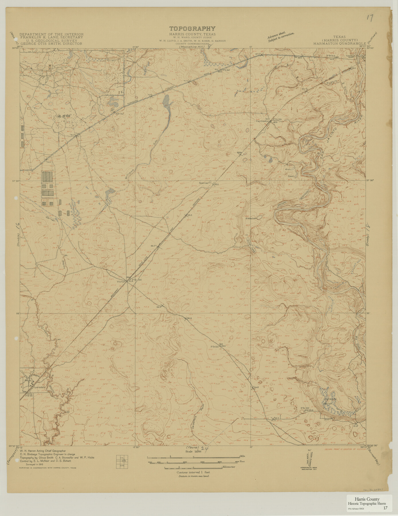
Harris County Historic Topographic 17
Harmaston Quadrangle
-
Map/Doc
65827
-
Collection
General Map Collection
-
Object Dates
1916 (Creation Date)
-
People and Organizations
U. S. Geological Survey (Publisher)
-
Counties
Harris
-
Subjects
Topographic
-
Height x Width
29.5 x 22.7 inches
74.9 x 57.7 cm
Part of: General Map Collection
Flight Mission No. CLL-1N, Frame 33, Willacy County

Print $20.00
- Digital $50.00
Flight Mission No. CLL-1N, Frame 33, Willacy County
1954
Size 18.4 x 22.1 inches
Map/Doc 87014
Nueces County Sketch File 1

Print $24.00
- Digital $50.00
Nueces County Sketch File 1
1847
Size 7.6 x 12.5 inches
Map/Doc 32497
Floyd County Sketch File 32a

Print $20.00
- Digital $50.00
Floyd County Sketch File 32a
1952
Size 36.5 x 33.1 inches
Map/Doc 10451
Jefferson County Rolled Sketch 2

Print $20.00
- Digital $50.00
Jefferson County Rolled Sketch 2
1904
Size 33.1 x 44.7 inches
Map/Doc 6383
Menard County

Print $20.00
- Digital $50.00
Menard County
1942
Size 43.6 x 47.7 inches
Map/Doc 77371
Hunt County Sketch File 27

Print $4.00
- Digital $50.00
Hunt County Sketch File 27
1860
Size 10.3 x 7.6 inches
Map/Doc 27126
Culberson County Working Sketch 65

Print $40.00
- Digital $50.00
Culberson County Working Sketch 65
1975
Size 49.0 x 34.9 inches
Map/Doc 68519
Trinity River, OwenCrossing Sheet/Elm Fork of Trinity River

Print $20.00
- Digital $50.00
Trinity River, OwenCrossing Sheet/Elm Fork of Trinity River
1914
Size 29.2 x 29.4 inches
Map/Doc 78340
Flight Mission No. CLL-1N, Frame 160, Willacy County

Print $20.00
- Digital $50.00
Flight Mission No. CLL-1N, Frame 160, Willacy County
1954
Size 18.3 x 22.0 inches
Map/Doc 87051
Flight Mission No. DQO-8K, Frame 71, Galveston County

Print $20.00
- Digital $50.00
Flight Mission No. DQO-8K, Frame 71, Galveston County
1952
Size 18.6 x 22.4 inches
Map/Doc 85175
Right of Way and Track Map Houston & Texas Central R.R. operated by the T. and N. O. R.R. Co., Fort Worth Branch

Print $40.00
- Digital $50.00
Right of Way and Track Map Houston & Texas Central R.R. operated by the T. and N. O. R.R. Co., Fort Worth Branch
1918
Size 30.7 x 56.4 inches
Map/Doc 64542
San Augustine County Sketch File 6

Print $4.00
San Augustine County Sketch File 6
1858
Size 6.4 x 7.7 inches
Map/Doc 35644
You may also like
Map showing surveys in Blocks 45, 3, R & 5T

Print $20.00
- Digital $50.00
Map showing surveys in Blocks 45, 3, R & 5T
1913
Size 30.2 x 37.5 inches
Map/Doc 496
Houston County Sketch File 20

Print $6.00
- Digital $50.00
Houston County Sketch File 20
1884
Size 16.9 x 11.3 inches
Map/Doc 26787
The Republic County of Fayette. May 24, 1838

Print $20.00
The Republic County of Fayette. May 24, 1838
2020
Size 14.7 x 21.7 inches
Map/Doc 96133
Montague County Working Sketch 25

Print $20.00
- Digital $50.00
Montague County Working Sketch 25
1955
Size 42.4 x 28.4 inches
Map/Doc 71091
General Highway Map, Winkler County, Texas

Print $20.00
General Highway Map, Winkler County, Texas
1961
Size 18.2 x 24.8 inches
Map/Doc 79716
The Coast & Bays of Western Texas, St. Joseph's and Mustang Islands from actual survey, the remainder from county maps, etc.

Print $20.00
- Digital $50.00
The Coast & Bays of Western Texas, St. Joseph's and Mustang Islands from actual survey, the remainder from county maps, etc.
1857
Size 27.9 x 18.3 inches
Map/Doc 72766
[Sketch of a portion of a Bastrop District GLO map]
![90112, [Sketch of a portion of a Bastrop District GLO map], Twichell Survey Records](https://historictexasmaps.com/wmedia_w700/maps/90112-1.tif.jpg)
Print $20.00
- Digital $50.00
[Sketch of a portion of a Bastrop District GLO map]
1923
Size 12.1 x 16.0 inches
Map/Doc 90112
Val Verde County Working Sketch 21

Print $20.00
- Digital $50.00
Val Verde County Working Sketch 21
1929
Size 15.2 x 30.0 inches
Map/Doc 72156
Bell County Working Sketch 4

Print $20.00
- Digital $50.00
Bell County Working Sketch 4
1942
Size 26.9 x 21.0 inches
Map/Doc 67344
Jno. W. Pritchett Preliminary Official LO Map for Lubbock [County]
![89901, Jno. W. Pritchett Preliminary Official LO Map for Lubbock [County], Twichell Survey Records](https://historictexasmaps.com/wmedia_w700/maps/89901-1.tif.jpg)
Print $20.00
- Digital $50.00
Jno. W. Pritchett Preliminary Official LO Map for Lubbock [County]
Size 41.1 x 40.3 inches
Map/Doc 89901
Harris County Rolled Sketch 96A

Print $20.00
- Digital $50.00
Harris County Rolled Sketch 96A
Size 45.7 x 37.7 inches
Map/Doc 9143
Plat Showing Land Owned by City of Lubbock out of Section 3, Block O

Print $20.00
- Digital $50.00
Plat Showing Land Owned by City of Lubbock out of Section 3, Block O
Size 40.4 x 31.1 inches
Map/Doc 92876