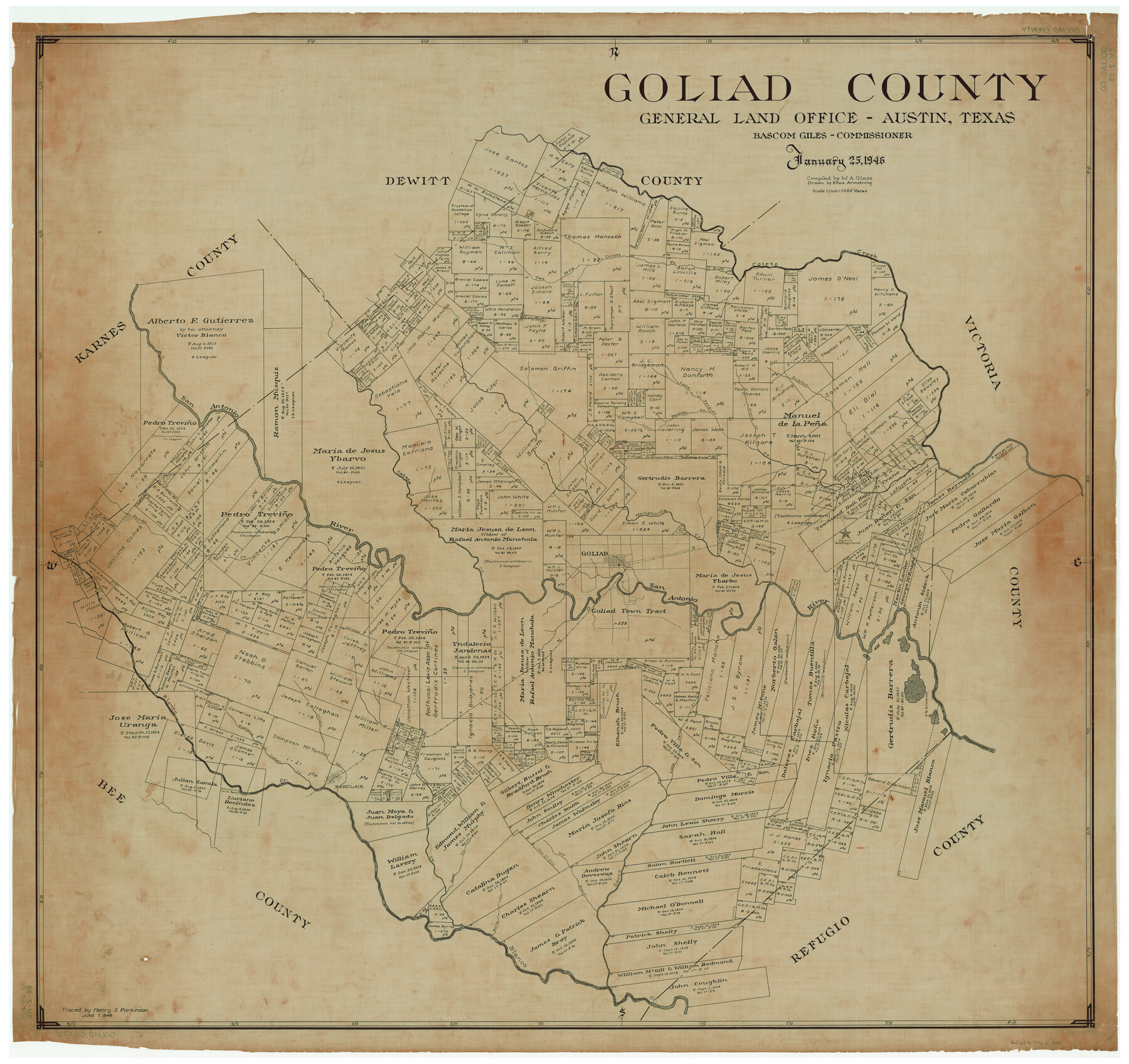
Goliad County
RM-2-88
-
Map/Doc
1840
-
Collection
General Map Collection
-
Object Dates
1946 (Creation Date)
-
People and Organizations
Texas General Land Office (Publisher)
Bascom Giles (GLO Commissioner)
Eltea Armstrong (Draftsman)
W.A. Glass (Compiler)
-
Counties
Goliad
-
Subjects
County
-
Height x Width
42.3 x 44.7 inches
107.4 x 113.5 cm
-
Comments
Traced June 7, 1946 by Henry S. Parkinson.
Part of: General Map Collection
Dimmit County Sketch File 20

Print $6.00
- Digital $50.00
Dimmit County Sketch File 20
1884
Size 13.0 x 8.7 inches
Map/Doc 21100
Erath County Working Sketch 46

Print $40.00
- Digital $50.00
Erath County Working Sketch 46
1983
Size 49.6 x 43.1 inches
Map/Doc 69127
El Paso County Boundary File 17

Print $8.00
- Digital $50.00
El Paso County Boundary File 17
Size 13.4 x 8.4 inches
Map/Doc 53192
Liberty County Sketch File 52

Print $20.00
- Digital $50.00
Liberty County Sketch File 52
Size 17.5 x 13.5 inches
Map/Doc 11995
Howard County Boundary File 1

Print $51.00
- Digital $50.00
Howard County Boundary File 1
Size 14.4 x 8.8 inches
Map/Doc 55086
[Missouri, Kansas & Texas Line Map through Bastrop County]
![64031, [Missouri, Kansas & Texas Line Map through Bastrop County], General Map Collection](https://historictexasmaps.com/wmedia_w700/maps/64031.tif.jpg)
Print $40.00
- Digital $50.00
[Missouri, Kansas & Texas Line Map through Bastrop County]
1916
Size 26.5 x 124.4 inches
Map/Doc 64031
Uvalde County Sketch File 20

Print $40.00
- Digital $50.00
Uvalde County Sketch File 20
1882
Size 15.0 x 13.2 inches
Map/Doc 39002
Colton's New Map of the State of Texas Compiled from J. De Cordova's Large Map

Print $20.00
- Digital $50.00
Colton's New Map of the State of Texas Compiled from J. De Cordova's Large Map
1858
Size 18.0 x 28.4 inches
Map/Doc 89225
Stephens County

Print $20.00
- Digital $50.00
Stephens County
1940
Size 40.3 x 38.9 inches
Map/Doc 77426
Starr County Sketch File 27

Print $20.00
- Digital $50.00
Starr County Sketch File 27
1930
Size 22.2 x 34.0 inches
Map/Doc 12333
Aransas Pass to Baffin Bay

Print $20.00
- Digital $50.00
Aransas Pass to Baffin Bay
1973
Size 42.0 x 35.1 inches
Map/Doc 73418
Karnes County Boundary File 4

Print $14.00
- Digital $50.00
Karnes County Boundary File 4
Size 12.7 x 8.2 inches
Map/Doc 55698
You may also like
Lee County Working Sketch 11

Print $20.00
- Digital $50.00
Lee County Working Sketch 11
1980
Size 25.2 x 25.7 inches
Map/Doc 70390
Culberson County Working Sketch 81

Print $40.00
- Digital $50.00
Culberson County Working Sketch 81
1980
Size 61.5 x 43.5 inches
Map/Doc 68535

San Patricio County Rolled Sketch 32

Print $20.00
- Digital $50.00
San Patricio County Rolled Sketch 32
1948
Size 38.8 x 25.0 inches
Map/Doc 7583
Preliminary Chart No. 31 of the Sea Coast of the United States from Galveston Bay to Matagorda Bay, Texas

Print $20.00
- Digital $50.00
Preliminary Chart No. 31 of the Sea Coast of the United States from Galveston Bay to Matagorda Bay, Texas
1857
Size 22.7 x 38.7 inches
Map/Doc 69949
Hays County Boundary File 4

Print $4.00
- Digital $50.00
Hays County Boundary File 4
Size 5.1 x 8.9 inches
Map/Doc 54607
General Highway Map, Brewster County, Texas

Print $20.00
General Highway Map, Brewster County, Texas
1961
Size 18.3 x 24.9 inches
Map/Doc 79386
Runnels County Sketch File 21A

Print $20.00
Runnels County Sketch File 21A
1886
Size 17.5 x 20.5 inches
Map/Doc 12256
[PSL Block B1 and T. & P. Blocks 45 and 46, Township 1N]
![91967, [PSL Block B1 and T. & P. Blocks 45 and 46, Township 1N], Twichell Survey Records](https://historictexasmaps.com/wmedia_w700/maps/91967-1.tif.jpg)
Print $20.00
- Digital $50.00
[PSL Block B1 and T. & P. Blocks 45 and 46, Township 1N]
Size 40.8 x 10.6 inches
Map/Doc 91967
Baylor County Sketch File A4

Print $8.00
- Digital $50.00
Baylor County Sketch File A4
Size 14.0 x 8.7 inches
Map/Doc 14084
J.K Gill & Cos Map of Oregon

Print $20.00
- Digital $50.00
J.K Gill & Cos Map of Oregon
1882
Size 29.0 x 32.3 inches
Map/Doc 94055
Flight Mission No. BRA-7M, Frame 31, Jefferson County

Print $20.00
- Digital $50.00
Flight Mission No. BRA-7M, Frame 31, Jefferson County
1953
Size 18.5 x 22.3 inches
Map/Doc 85482