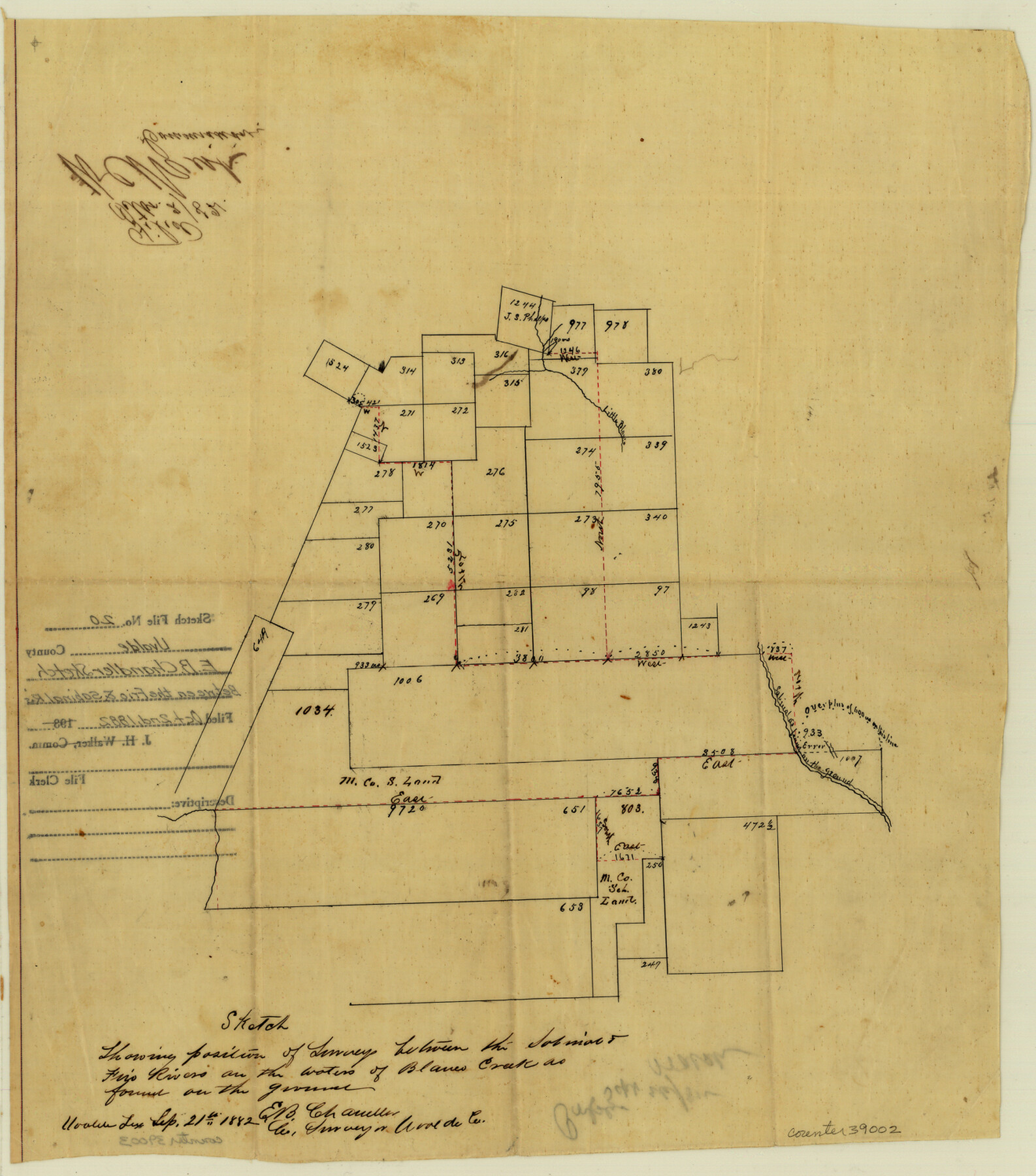
Uvalde County Sketch File 20
Sketch showing position of surveys between the Sabinal and Frio Rivers on the waters of Blanco Creek
-
Map/Doc
39002
-
Collection
General Map Collection
-
Object Dates
9/21/1882 (Creation Date)
10/2/1882 (File Date)
-
People and Organizations
E.B. Chandler (Surveyor/Engineer)
-
Counties
Uvalde
-
Subjects
Surveying Sketch File
-
Height x Width
15.0 x 13.2 inches
38.1 x 33.5 cm
-
Medium
paper, manuscript
-
Features
Little Blanco Creek
Sabinal River
Frio River
Part of: General Map Collection
Lampasas County Boundary File 3

Print $10.00
- Digital $50.00
Lampasas County Boundary File 3
Size 8.4 x 7.3 inches
Map/Doc 56101
Culberson County Rolled Sketch 19

Print $20.00
- Digital $50.00
Culberson County Rolled Sketch 19
Size 18.8 x 29.4 inches
Map/Doc 5651
Reagan County

Print $40.00
- Digital $50.00
Reagan County
1915
Size 51.6 x 38.6 inches
Map/Doc 73340
Brooks County Boundary File 1

Print $54.00
- Digital $50.00
Brooks County Boundary File 1
Size 9.0 x 8.6 inches
Map/Doc 50809
Webb County Sketch File 14b

Print $4.00
- Digital $50.00
Webb County Sketch File 14b
1897
Size 11.2 x 8.8 inches
Map/Doc 39812
Reagan County Rolled Sketch 27A

Print $40.00
- Digital $50.00
Reagan County Rolled Sketch 27A
1952
Size 63.7 x 47.2 inches
Map/Doc 9822
Kimble County Working Sketch 25

Print $20.00
- Digital $50.00
Kimble County Working Sketch 25
1937
Size 22.9 x 22.7 inches
Map/Doc 70093
Sketch C Showing the Progress of the Survey in Section III From 1843 to 1852

Print $20.00
- Digital $50.00
Sketch C Showing the Progress of the Survey in Section III From 1843 to 1852
1852
Size 36.2 x 25.6 inches
Map/Doc 97201
Williamson County Sketch File 3

Print $24.00
- Digital $50.00
Williamson County Sketch File 3
1853
Size 13.0 x 8.2 inches
Map/Doc 40301
Wheeler County Working Sketch 14

Print $20.00
- Digital $50.00
Wheeler County Working Sketch 14
1979
Size 20.1 x 37.2 inches
Map/Doc 72503
Jeff Davis County Working Sketch 4

Print $20.00
- Digital $50.00
Jeff Davis County Working Sketch 4
1916
Size 14.3 x 15.2 inches
Map/Doc 66499
Flight Mission No. DIX-7P, Frame 24, Aransas County

Print $20.00
- Digital $50.00
Flight Mission No. DIX-7P, Frame 24, Aransas County
1956
Size 18.6 x 22.6 inches
Map/Doc 83876
You may also like
Swisher County Working Sketch 2

Print $20.00
- Digital $50.00
Swisher County Working Sketch 2
1950
Size 21.5 x 21.7 inches
Map/Doc 62413
Roberts County Working Sketch 11

Print $40.00
- Digital $50.00
Roberts County Working Sketch 11
1966
Size 57.6 x 38.6 inches
Map/Doc 63537
Hutchinson County Sketch File 28

Print $6.00
- Digital $50.00
Hutchinson County Sketch File 28
1926
Size 11.3 x 8.8 inches
Map/Doc 27261
Map of Montague County

Print $20.00
- Digital $50.00
Map of Montague County
1868
Size 24.1 x 19.7 inches
Map/Doc 3887
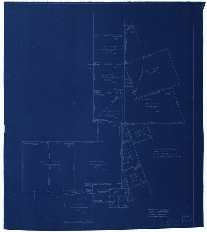
Bee County Working Sketch 3
Print $20.00
- Digital $50.00
Bee County Working Sketch 3
1915
Size 22.8 x 20.3 inches
Map/Doc 67253
[Norwood Homestead]
![91879, [Norwood Homestead], Twichell Survey Records](https://historictexasmaps.com/wmedia_w700/maps/91879-1.tif.jpg)
Print $20.00
- Digital $50.00
[Norwood Homestead]
Size 21.1 x 21.8 inches
Map/Doc 91879
Bosque County Sketch File 10

Print $4.00
- Digital $50.00
Bosque County Sketch File 10
1859
Size 12.9 x 8.2 inches
Map/Doc 14757
Harris County Working Sketch 12

Print $20.00
- Digital $50.00
Harris County Working Sketch 12
1913
Size 17.7 x 21.3 inches
Map/Doc 65904
Palo Pinto County

Print $20.00
- Digital $50.00
Palo Pinto County
1896
Size 27.2 x 22.1 inches
Map/Doc 3937
Shelby County Sketch File 27

Print $4.00
- Digital $50.00
Shelby County Sketch File 27
Size 6.5 x 8.0 inches
Map/Doc 36662
[Surveys in San Jacinto and Polk Counties]
![69749, [Surveys in San Jacinto and Polk Counties], General Map Collection](https://historictexasmaps.com/wmedia_w700/maps/69749.tif.jpg)
Print $2.00
- Digital $50.00
[Surveys in San Jacinto and Polk Counties]
Size 9.8 x 3.8 inches
Map/Doc 69749
Upshur County Working Sketch 3

Print $20.00
- Digital $50.00
Upshur County Working Sketch 3
1934
Size 24.6 x 36.3 inches
Map/Doc 69559