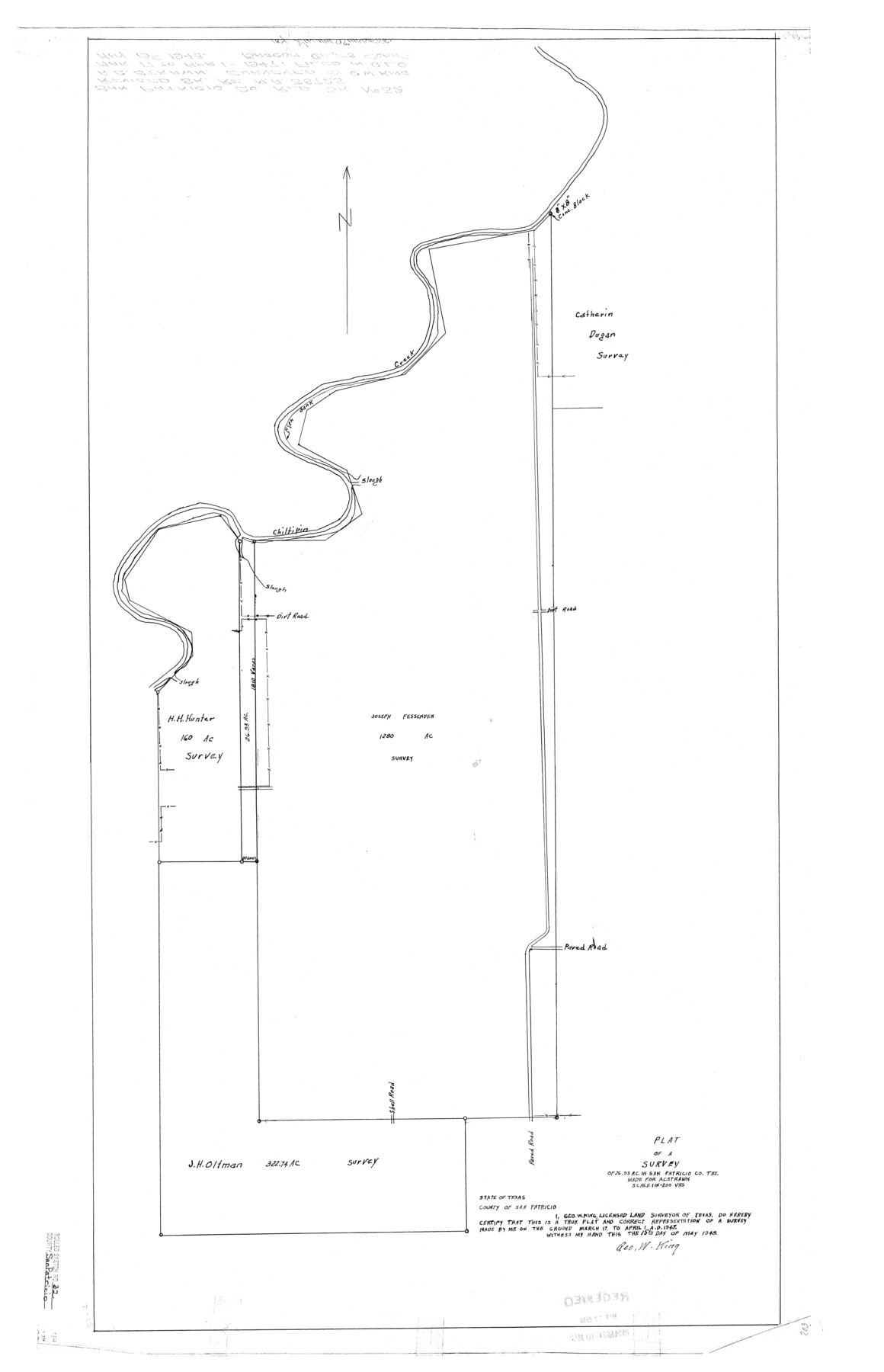
San Patricio County Rolled Sketch 32
Plat of a survey of 26.93 ac. in San Patricio Co., Tex. made for A.C. Strawn
-
Map/Doc
7583
-
Collection
General Map Collection
-
Object Dates
1947/4/1 (Survey Date)
1948/5/15 (Creation Date)
1948/5/19 (File Date)
-
People and Organizations
Geo. W. King (Surveyor/Engineer)
-
Counties
San Patricio
-
Subjects
Surveying Rolled Sketch
-
Height x Width
38.8 x 25.0 inches
98.6 x 63.5 cm
-
Scale
1" = 200 varas
Part of: General Map Collection
Eastland County Rolled Sketch 3

Print $20.00
- Digital $50.00
Eastland County Rolled Sketch 3
1893
Size 24.4 x 41.3 inches
Map/Doc 5773
Gillespie County Rolled Sketch 5

Print $20.00
- Digital $50.00
Gillespie County Rolled Sketch 5
1994
Size 25.7 x 20.6 inches
Map/Doc 6012
Upton County Rolled Sketch 24

Print $20.00
- Digital $50.00
Upton County Rolled Sketch 24
1886
Size 17.3 x 43.5 inches
Map/Doc 10043
Map of Zapata County

Print $20.00
- Digital $50.00
Map of Zapata County
1863
Size 35.0 x 28.0 inches
Map/Doc 4175
Sutton County Sketch File C

Print $6.00
- Digital $50.00
Sutton County Sketch File C
1900
Size 14.0 x 8.6 inches
Map/Doc 37379
Medina County Rolled Sketch 14

Print $20.00
- Digital $50.00
Medina County Rolled Sketch 14
1980
Size 29.2 x 32.0 inches
Map/Doc 6748
Flight Mission No. BRE-1P, Frame 80, Nueces County

Print $20.00
- Digital $50.00
Flight Mission No. BRE-1P, Frame 80, Nueces County
1956
Size 18.4 x 22.3 inches
Map/Doc 86662
[T. & N. O. R.R. Jefferson Co. North]
![64055, [T. & N. O. R.R. Jefferson Co. North], General Map Collection](https://historictexasmaps.com/wmedia_w700/maps/64055.tif.jpg)
Print $20.00
- Digital $50.00
[T. & N. O. R.R. Jefferson Co. North]
Size 13.4 x 33.4 inches
Map/Doc 64055
Edwards County Rolled Sketch N

Print $20.00
- Digital $50.00
Edwards County Rolled Sketch N
1934
Size 18.9 x 23.7 inches
Map/Doc 6066
Water-Shed of the Pease River Drainage Area

Print $6.00
- Digital $50.00
Water-Shed of the Pease River Drainage Area
Size 14.9 x 31.0 inches
Map/Doc 65102
Foard County Sketch File 9

Print $20.00
- Digital $50.00
Foard County Sketch File 9
1882
Size 19.7 x 17.1 inches
Map/Doc 11492
Estes Quadrangle

Print $20.00
- Digital $50.00
Estes Quadrangle
1971
Size 27.8 x 23.6 inches
Map/Doc 73442
You may also like
Coke County Rolled Sketch 21

Print $20.00
- Digital $50.00
Coke County Rolled Sketch 21
1954
Size 14.0 x 24.4 inches
Map/Doc 5522
Shelby County Rolled Sketch 15

Print $40.00
- Digital $50.00
Shelby County Rolled Sketch 15
1948
Size 22.8 x 54.4 inches
Map/Doc 10313
The Mercer Colony. January 29, 1844

Print $20.00
The Mercer Colony. January 29, 1844
2020
Size 19.8 x 21.7 inches
Map/Doc 96361
[I. &G. N. RR. Co. Block I along Pecos River and other Blocks to the West]
![89827, [I. &G. N. RR. Co. Block I along Pecos River and other Blocks to the West], Twichell Survey Records](https://historictexasmaps.com/wmedia_w700/maps/89827-1.tif.jpg)
Print $20.00
- Digital $50.00
[I. &G. N. RR. Co. Block I along Pecos River and other Blocks to the West]
Size 44.4 x 45.2 inches
Map/Doc 89827
Howard County Working Sketch 9b

Print $20.00
- Digital $50.00
Howard County Working Sketch 9b
1962
Size 33.9 x 37.4 inches
Map/Doc 66277
United States Base Map

Print $20.00
- Digital $50.00
United States Base Map
1916
Size 19.2 x 29.5 inches
Map/Doc 69653
El Paso County Rolled Sketch 2A

Print $20.00
- Digital $50.00
El Paso County Rolled Sketch 2A
1889
Size 24.1 x 32.8 inches
Map/Doc 5821
Harris County Historic Topographic 5

Print $20.00
- Digital $50.00
Harris County Historic Topographic 5
1916
Size 29.2 x 22.8 inches
Map/Doc 65815
Map of Power and Hewetson Colony

Print $20.00
- Digital $50.00
Map of Power and Hewetson Colony
1841
Size 34.8 x 24.3 inches
Map/Doc 1950
Freestone County Working Sketch 32

Print $20.00
- Digital $50.00
Freestone County Working Sketch 32
1997
Size 46.5 x 34.0 inches
Map/Doc 69274
Jasper County Working Sketch 31

Print $20.00
- Digital $50.00
Jasper County Working Sketch 31
1963
Size 38.2 x 37.7 inches
Map/Doc 66493
La Salle County Sketch File 44

Print $20.00
- Digital $50.00
La Salle County Sketch File 44
1937
Size 18.6 x 27.9 inches
Map/Doc 11989