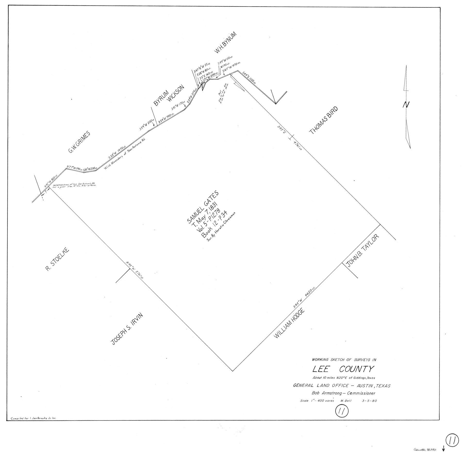
Lee County Working Sketch 11
-
Map/Doc
70390
-
Collection
General Map Collection
-
Object Dates
3/5/1980 (Creation Date)
-
People and Organizations
M. Bell (Draftsman)
-
Counties
Lee
-
Subjects
Surveying Working Sketch
-
Height x Width
25.2 x 25.7 inches
64.0 x 65.3 cm
-
Scale
1" = 400 varas
Part of: General Map Collection
Flight Mission No. CLL-1N, Frame 157, Willacy County

Print $20.00
- Digital $50.00
Flight Mission No. CLL-1N, Frame 157, Willacy County
1954
Size 18.3 x 22.0 inches
Map/Doc 87048
Flight Mission No. BQY-15M, Frame 10, Harris County

Print $20.00
- Digital $50.00
Flight Mission No. BQY-15M, Frame 10, Harris County
1953
Size 18.5 x 22.3 inches
Map/Doc 85308
Gaines County Working Sketch 31

Print $20.00
- Digital $50.00
Gaines County Working Sketch 31
1990
Size 37.4 x 26.8 inches
Map/Doc 69331
Culberson County Rolled Sketch 66

Print $20.00
- Digital $50.00
Culberson County Rolled Sketch 66
1987
Size 24.4 x 19.7 inches
Map/Doc 5682
Kerr County Working Sketch 23

Print $20.00
- Digital $50.00
Kerr County Working Sketch 23
1966
Size 33.4 x 41.0 inches
Map/Doc 70054
Old Miscellaneous File 26

Print $4.00
- Digital $50.00
Old Miscellaneous File 26
Size 14.3 x 9.0 inches
Map/Doc 75634
Nueces County Rolled Sketch 103

Print $105.00
Nueces County Rolled Sketch 103
1985
Size 36.5 x 24.1 inches
Map/Doc 7078
Duval County Sketch File 13

Print $4.00
- Digital $50.00
Duval County Sketch File 13
1876
Size 8.5 x 10.3 inches
Map/Doc 21306
Webb County Rolled Sketch 57

Print $20.00
- Digital $50.00
Webb County Rolled Sketch 57
Size 23.5 x 32.2 inches
Map/Doc 8209
Cameron County Rolled Sketch Z8

Print $20.00
- Digital $50.00
Cameron County Rolled Sketch Z8
1937
Size 30.3 x 34.5 inches
Map/Doc 5406
Sterling County Sketch File A

Print $20.00
- Digital $50.00
Sterling County Sketch File A
1906
Size 18.2 x 26.0 inches
Map/Doc 12362
Flight Mission No. BRA-7M, Frame 142, Jefferson County

Print $20.00
- Digital $50.00
Flight Mission No. BRA-7M, Frame 142, Jefferson County
1953
Size 18.6 x 22.5 inches
Map/Doc 85536
You may also like
Robertson County Sketch File 12

Print $18.00
Robertson County Sketch File 12
1987
Size 11.4 x 8.8 inches
Map/Doc 35404
[Sketch for Mineral Application 24072, San Jacinto River]
![65595, [Sketch for Mineral Application 24072, San Jacinto River], General Map Collection](https://historictexasmaps.com/wmedia_w700/maps/65595.tif.jpg)
Print $20.00
- Digital $50.00
[Sketch for Mineral Application 24072, San Jacinto River]
1929
Size 15.0 x 17.5 inches
Map/Doc 65595
Bexar County Sketch File 43

Print $4.00
- Digital $50.00
Bexar County Sketch File 43
1882
Size 8.7 x 10.2 inches
Map/Doc 14522
Kenedy County Rolled Sketch 9

Print $20.00
- Digital $50.00
Kenedy County Rolled Sketch 9
Size 27.1 x 41.7 inches
Map/Doc 6469
Smith County Working Sketch 16

Print $20.00
- Digital $50.00
Smith County Working Sketch 16
1988
Size 33.6 x 44.9 inches
Map/Doc 63901
Starr County Sketch File 48a

Print $40.00
- Digital $50.00
Starr County Sketch File 48a
1950
Size 9.0 x 22.0 inches
Map/Doc 37005
Flight Mission No. BRA-8M, Frame 123, Jefferson County

Print $20.00
- Digital $50.00
Flight Mission No. BRA-8M, Frame 123, Jefferson County
1953
Size 18.7 x 22.3 inches
Map/Doc 85619
Map showing the Distribution of Slaves in the Southern States

Print $20.00
- Digital $50.00
Map showing the Distribution of Slaves in the Southern States
1861
Size 15.2 x 18.3 inches
Map/Doc 96634
Sectional map of Texas traversed by the Missouri, Kansas & Texas Railway, showing the crops adapted to each section, with the elevation and annual rainfall

Print $20.00
- Digital $50.00
Sectional map of Texas traversed by the Missouri, Kansas & Texas Railway, showing the crops adapted to each section, with the elevation and annual rainfall
1904
Size 21.9 x 23.0 inches
Map/Doc 95815
Brewster County Working Sketch 7

Print $20.00
- Digital $50.00
Brewster County Working Sketch 7
1909
Size 39.9 x 17.1 inches
Map/Doc 67540
Dickens County Working Sketch 13

Print $20.00
- Digital $50.00
Dickens County Working Sketch 13
1981
Size 26.8 x 21.4 inches
Map/Doc 68661
Blanco County Sketch File 39

Print $4.00
- Digital $50.00
Blanco County Sketch File 39
Size 8.6 x 13.9 inches
Map/Doc 14650