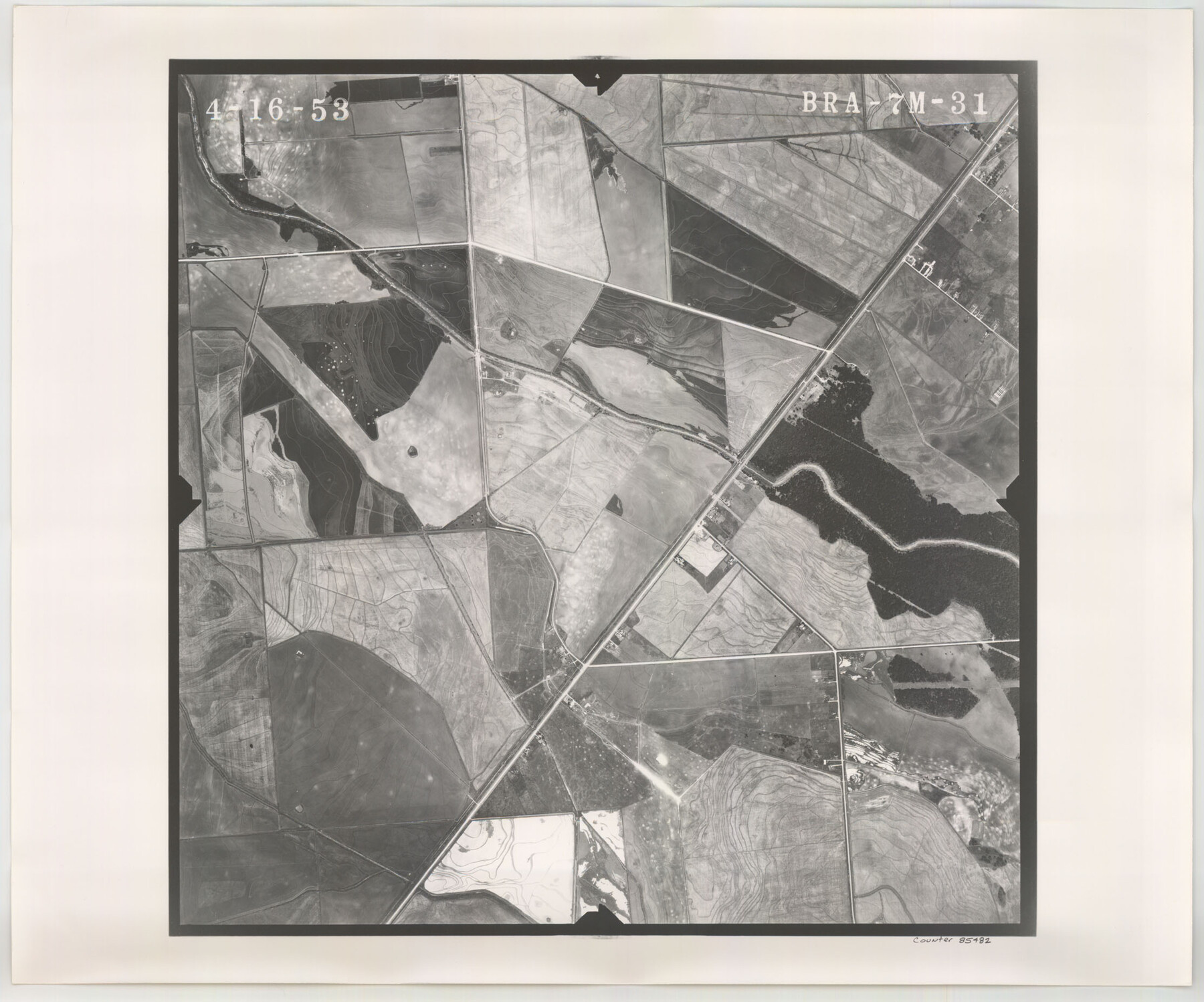
Flight Mission No. BRA-7M, Frame 31, Jefferson County
BRA-7M-31
-
Map/Doc
85482
-
Collection
General Map Collection
-
Object Dates
1953/4/16 (Creation Date)
-
People and Organizations
U. S. Department of Agriculture (Publisher)
-
Counties
Jefferson
-
Subjects
Aerial Photograph
-
Height x Width
18.5 x 22.3 inches
47.0 x 56.6 cm
-
Comments
Flown by Jack Ammann Photogrammetric Engineers of San Antonio, Texas.
Part of: General Map Collection
No. 3 Chart of Channel connecting Corpus Christi Bay with Aransas Bay, Texas

Print $20.00
- Digital $50.00
No. 3 Chart of Channel connecting Corpus Christi Bay with Aransas Bay, Texas
1878
Size 18.1 x 27.8 inches
Map/Doc 72780
Flight Mission No. BRA-7M, Frame 85, Jefferson County

Print $20.00
- Digital $50.00
Flight Mission No. BRA-7M, Frame 85, Jefferson County
1953
Size 18.7 x 22.4 inches
Map/Doc 85507
Liberty County Sketch File 36

Print $2.00
- Digital $50.00
Liberty County Sketch File 36
Size 9.4 x 9.0 inches
Map/Doc 29973
[Plat of Trinity River w/ Midstream Profile in Liberty County by US Government 1899]
![65336, [Plat of Trinity River w/ Midstream Profile in Liberty County by US Government 1899], General Map Collection](https://historictexasmaps.com/wmedia_w700/maps/65336.tif.jpg)
Print $20.00
- Digital $50.00
[Plat of Trinity River w/ Midstream Profile in Liberty County by US Government 1899]
1899
Size 10.8 x 18.3 inches
Map/Doc 65336
[Gulf, Colorado & Santa Fe Railway line through Fort Bend Co.]
![64212, [Gulf, Colorado & Santa Fe Railway line through Fort Bend Co.], General Map Collection](https://historictexasmaps.com/wmedia_w700/maps/64212.tif.jpg)
Print $20.00
- Digital $50.00
[Gulf, Colorado & Santa Fe Railway line through Fort Bend Co.]
1898
Size 14.2 x 33.5 inches
Map/Doc 64212
North America in the Age of Dinosaurs

North America in the Age of Dinosaurs
1993
Size 27.4 x 20.8 inches
Map/Doc 96831
Irion County Rolled Sketch 9

Print $20.00
- Digital $50.00
Irion County Rolled Sketch 9
1940
Size 31.9 x 30.6 inches
Map/Doc 6321
[Surveys in the Nacogdoches District, Rusk County]
![339, [Surveys in the Nacogdoches District, Rusk County], General Map Collection](https://historictexasmaps.com/wmedia_w700/maps/339.tif.jpg)
Print $2.00
- Digital $50.00
[Surveys in the Nacogdoches District, Rusk County]
Size 6.0 x 8.2 inches
Map/Doc 339
Burleson County Working Sketch Graphic Index

Print $20.00
- Digital $50.00
Burleson County Working Sketch Graphic Index
1978
Size 35.0 x 46.1 inches
Map/Doc 76481
Scurry County Sketch File 5

Print $4.00
- Digital $50.00
Scurry County Sketch File 5
1990
Size 14.4 x 8.9 inches
Map/Doc 36568
Loving County Rolled Sketch 10

Print $20.00
- Digital $50.00
Loving County Rolled Sketch 10
1990
Size 32.0 x 43.6 inches
Map/Doc 9468
[San Antonio & Aransas Pass]
![64211, [San Antonio & Aransas Pass], General Map Collection](https://historictexasmaps.com/wmedia_w700/maps/64211.tif.jpg)
Print $2.00
- Digital $50.00
[San Antonio & Aransas Pass]
Size 11.6 x 8.2 inches
Map/Doc 64211
You may also like
Randall County Rolled Sketch 8

Print $20.00
- Digital $50.00
Randall County Rolled Sketch 8
Size 32.9 x 40.6 inches
Map/Doc 7429

Part of Laguna Madre from Mosquito Trangulation Station to Sand Triangulation Station

Print $40.00
- Digital $50.00
Part of Laguna Madre from Mosquito Trangulation Station to Sand Triangulation Station
1881
Size 34.5 x 54.6 inches
Map/Doc 73486
Houston County Sketch File 22

Print $8.00
- Digital $50.00
Houston County Sketch File 22
1852
Size 12.6 x 8.2 inches
Map/Doc 26789
Hunt County Sketch File 11

Print $4.00
- Digital $50.00
Hunt County Sketch File 11
1860
Size 12.1 x 7.6 inches
Map/Doc 27102
Karnes County Working Sketch 14

Print $3.00
- Digital $50.00
Karnes County Working Sketch 14
1981
Size 16.9 x 9.3 inches
Map/Doc 66662
The Mexican Municipality of Matagorda. Created, March 6, 1834

Print $20.00
The Mexican Municipality of Matagorda. Created, March 6, 1834
2020
Size 15.9 x 21.7 inches
Map/Doc 96025
Roberts County Working Sketch 28

Print $20.00
- Digital $50.00
Roberts County Working Sketch 28
1983
Size 39.7 x 29.8 inches
Map/Doc 63554
Flight Mission No. BRE-3P, Frame 34, Nueces County

Print $20.00
- Digital $50.00
Flight Mission No. BRE-3P, Frame 34, Nueces County
1956
Size 18.5 x 22.3 inches
Map/Doc 86812
Map of the Lands Surveyed by the Memphis, El Paso & Pacific R.R. Company

Print $20.00
- Digital $50.00
Map of the Lands Surveyed by the Memphis, El Paso & Pacific R.R. Company
1859
Size 11.4 x 18.6 inches
Map/Doc 4850
Crockett County

Print $40.00
- Digital $50.00
Crockett County
1882
Size 57.1 x 67.6 inches
Map/Doc 82212
Flight Mission No. CUG-3P, Frame 141, Kleberg County

Print $20.00
- Digital $50.00
Flight Mission No. CUG-3P, Frame 141, Kleberg County
1956
Size 18.4 x 22.2 inches
Map/Doc 86276