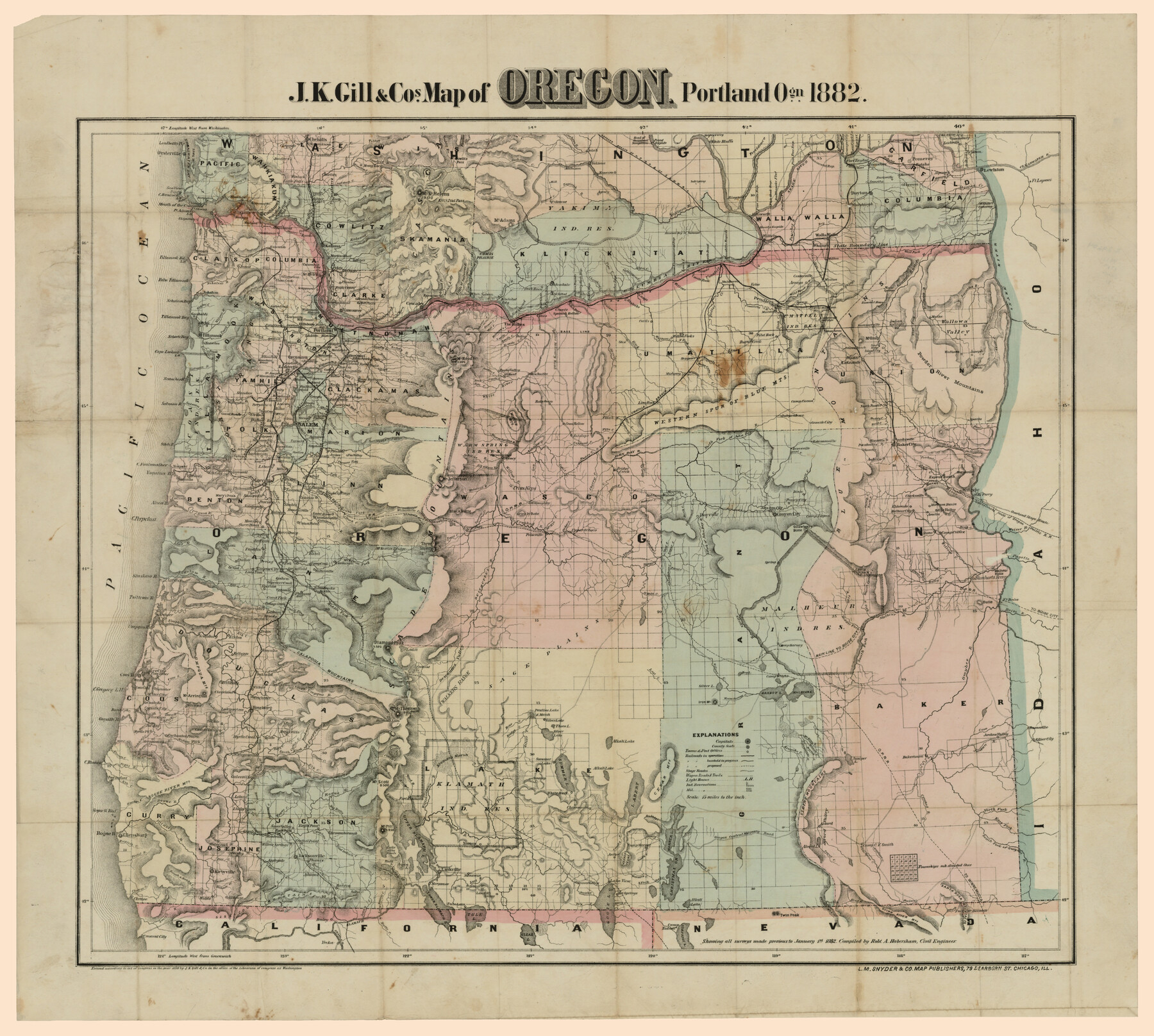
J.K Gill & Cos Map of Oregon
-
Map/Doc
94055
-
Collection
Rees-Jones Digital Map Collection
-
Object Dates
1882 (Creation Date)
-
People and Organizations
L.M. Snyder & Co. Map Publishers (Publisher)
J.K. Gill (Author)
Robt. A. Habersham (Compiler)
-
Height x Width
29.0 x 32.3 inches
73.7 x 82.0 cm
-
Medium
digital image
-
Comments
Courtesy of the Rees-Jones Collection, Dallas, TX
Part of: Rees-Jones Digital Map Collection
Map of Texas comprising the grant of the Texian Emigration and Land-Company

Print $20.00
- Digital $50.00
Map of Texas comprising the grant of the Texian Emigration and Land-Company
1843
Size 9.4 x 10.1 inches
Map/Doc 94049
Military Map of parts of Kansas, Nebraska and Dakota by Lieut. G.K. Warren, Top. Engrs. from the Explorations made by him in 1855, 56 & 57 exhibiting also routes reconnouered [sic] and surveyed by various other government officers
![93995, Military Map of parts of Kansas, Nebraska and Dakota by Lieut. G.K. Warren, Top. Engrs. from the Explorations made by him in 1855, 56 & 57 exhibiting also routes reconnouered [sic] and surveyed by various other government officers, Rees-Jones Digital Map Collection](https://historictexasmaps.com/wmedia_w700/maps/93995-1.tif.jpg)
Print $20.00
- Digital $50.00
Military Map of parts of Kansas, Nebraska and Dakota by Lieut. G.K. Warren, Top. Engrs. from the Explorations made by him in 1855, 56 & 57 exhibiting also routes reconnouered [sic] and surveyed by various other government officers
Size 19.9 x 35.6 inches
Map/Doc 93995
New Map of the Mining Regions of Idaho and Montana showing the geographical positions of the Blackfoot, Owyhee & South Boise Mines and the various routes thereto

Print $20.00
- Digital $50.00
New Map of the Mining Regions of Idaho and Montana showing the geographical positions of the Blackfoot, Owyhee & South Boise Mines and the various routes thereto
Size 21.9 x 29.4 inches
Map/Doc 93991
Part of the boundary between the United States and Texas; north of Sabine River, from the 72nd mile mound to the Red River

Print $3.00
- Digital $50.00
Part of the boundary between the United States and Texas; north of Sabine River, from the 72nd mile mound to the Red River
1842
Size 12.8 x 8.1 inches
Map/Doc 93771
J. De Cordova's Map of the State of Texas Compiled from the records of the General Land Office of the State

Print $20.00
- Digital $50.00
J. De Cordova's Map of the State of Texas Compiled from the records of the General Land Office of the State
1861
Size 36.9 x 34.9 inches
Map/Doc 93931
Map of Texas With Parts of the Adjoining States

Print $20.00
- Digital $50.00
Map of Texas With Parts of the Adjoining States
1836
Size 30.9 x 24.8 inches
Map/Doc 93932
A New Map of Texas, Oregon and California with the regions adjoining, compiled from the most recent authorities

Print $20.00
- Digital $50.00
A New Map of Texas, Oregon and California with the regions adjoining, compiled from the most recent authorities
Size 22.8 x 20.9 inches
Map/Doc 93990
A New Map of the United States upon which are delineated its vast works of internal communication, routes across the continent &c. showing also Canada and the Island of Cuba

Print $20.00
- Digital $50.00
A New Map of the United States upon which are delineated its vast works of internal communication, routes across the continent &c. showing also Canada and the Island of Cuba
Size 25.8 x 30.6 inches
Map/Doc 93996
Geological map of Texas showing approximate locations and drilling wells. Also names of companies drilling

Print $20.00
- Digital $50.00
Geological map of Texas showing approximate locations and drilling wells. Also names of companies drilling
1920
Size 26.9 x 26.6 inches
Map/Doc 93937
Outline Map showing a new route from Texas to Fort Yuma, California for cattle droves and trains en route to California

Print $40.00
- Digital $50.00
Outline Map showing a new route from Texas to Fort Yuma, California for cattle droves and trains en route to California
1870
Size 17.3 x 52.7 inches
Map/Doc 94048
Rand, McNally & Co's New Mexico

Print $20.00
- Digital $50.00
Rand, McNally & Co's New Mexico
1880
Size 21.4 x 14.7 inches
Map/Doc 94050
Mapa de los Estados Unidos de Méjico, Segun lo organizado y definido por las varias actas del Congreso de dicha Republica: y construido por las mejores autoridades

Print $20.00
- Digital $50.00
Mapa de los Estados Unidos de Méjico, Segun lo organizado y definido por las varias actas del Congreso de dicha Republica: y construido por las mejores autoridades
1847
Size 31.2 x 42.9 inches
Map/Doc 93763
You may also like
Newton County Sketch File 7

Print $4.00
- Digital $50.00
Newton County Sketch File 7
1872
Size 6.1 x 8.3 inches
Map/Doc 32374
Ellis County Boundary File 5

Print $4.00
- Digital $50.00
Ellis County Boundary File 5
Size 11.5 x 7.2 inches
Map/Doc 52990

Crockett County Working Sketch 73

Print $20.00
- Digital $50.00
Crockett County Working Sketch 73
1963
Size 38.8 x 33.8 inches
Map/Doc 68406
Presidio County Working Sketch 87

Print $20.00
- Digital $50.00
Presidio County Working Sketch 87
1971
Size 37.6 x 37.9 inches
Map/Doc 71764
Map of the Texas & Pacific Railway and connections

Print $20.00
- Digital $50.00
Map of the Texas & Pacific Railway and connections
1902
Size 18.0 x 36.8 inches
Map/Doc 95413
Flight Mission No. CRK-8P, Frame 116, Refugio County

Print $20.00
- Digital $50.00
Flight Mission No. CRK-8P, Frame 116, Refugio County
1956
Size 18.3 x 22.1 inches
Map/Doc 86971
[Texas & Pacific Block 32, T-4-N showing ties to triangulation stations]
![90143, [Texas & Pacific Block 32, T-4-N showing ties to triangulation stations], Twichell Survey Records](https://historictexasmaps.com/wmedia_w700/maps/90143-1.tif.jpg)
Print $20.00
- Digital $50.00
[Texas & Pacific Block 32, T-4-N showing ties to triangulation stations]
Size 20.4 x 11.5 inches
Map/Doc 90143
San Patricio County NRC Article 33.136 Location Key Sheet

Print $20.00
- Digital $50.00
San Patricio County NRC Article 33.136 Location Key Sheet
1975
Size 27.0 x 23.0 inches
Map/Doc 77035
Tarrant County Sketch File 25

Print $4.00
- Digital $50.00
Tarrant County Sketch File 25
1873
Size 8.2 x 8.6 inches
Map/Doc 37737
Reference Book of Burnet's, [Vehlein's] & Zavala's Colonies
![94554, Reference Book of Burnet's, [Vehlein's] & Zavala's Colonies, Historical Volumes](https://historictexasmaps.com/wmedia_w700/pdf_converted_jpg/qi_pdf_thumbnail_39143.jpg)
Reference Book of Burnet's, [Vehlein's] & Zavala's Colonies
Map/Doc 94554
Angelina County Sketch File 20

Print $40.00
- Digital $50.00
Angelina County Sketch File 20
1882
Size 19.7 x 29.4 inches
Map/Doc 10816