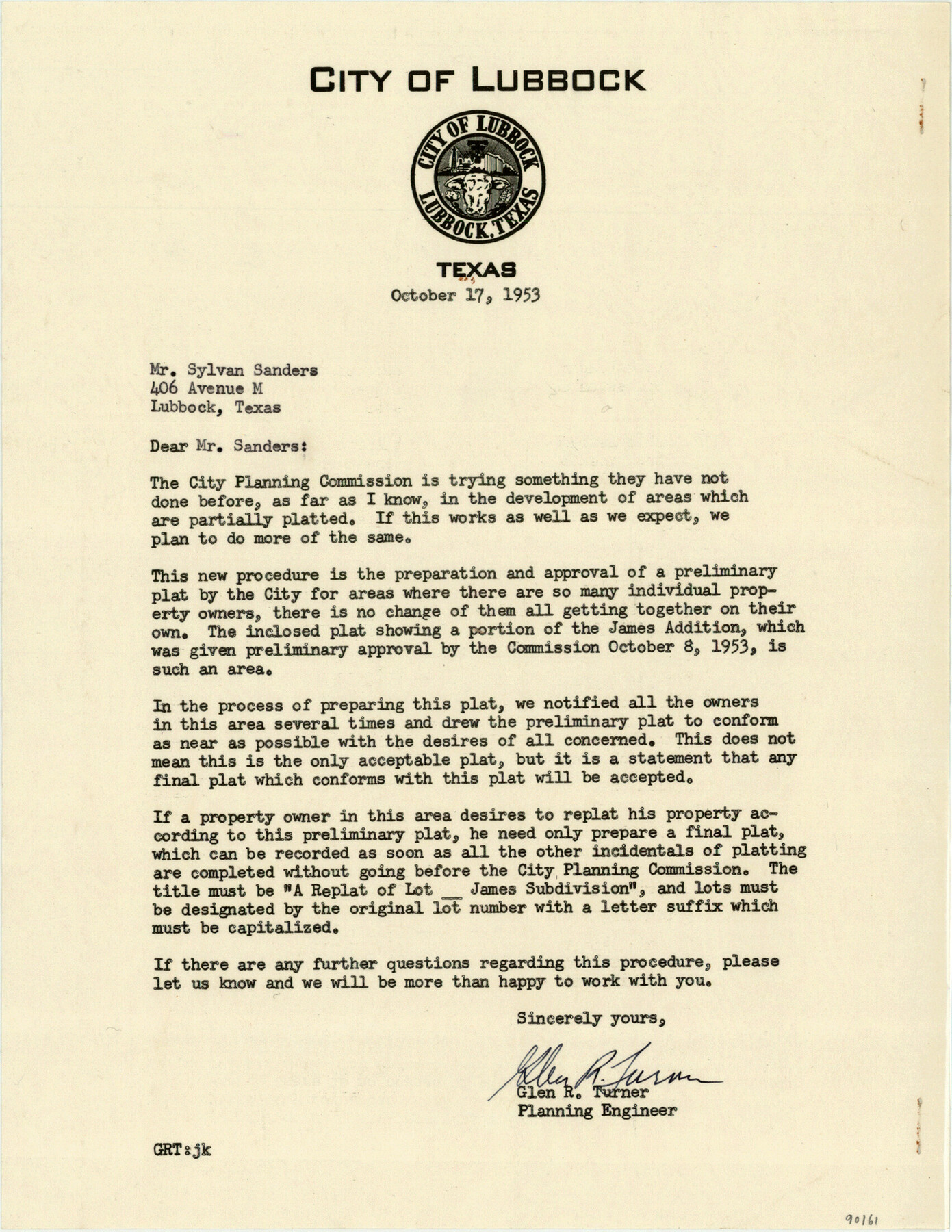
Preliminary Re-Plat of Lots 13-20, 45-52, 77-84, and 97-104 James Subdivision
-
Map/Doc
93221
-
Collection
Twichell Survey Records
-
Object Dates
10/17/1953 (Creation Date)
-
People and Organizations
Glen R. Turner (Surveyor/Engineer)
-
Counties
Lubbock
-
Height x Width
8.7 x 11.3 inches
22.1 x 28.7 cm
-
Comments
see plat, counter 93222
Part of: Twichell Survey Records
[University Lands Blocks 16, 18, 19 and 20]
![91594, [University Lands Blocks 16, 18, 19 and 20], Twichell Survey Records](https://historictexasmaps.com/wmedia_w700/maps/91594-1.tif.jpg)
Print $20.00
- Digital $50.00
[University Lands Blocks 16, 18, 19 and 20]
Size 13.9 x 16.7 inches
Map/Doc 91594
Sketch of Southwest Corner of Palo Pinto County

Print $20.00
- Digital $50.00
Sketch of Southwest Corner of Palo Pinto County
Size 13.9 x 12.0 inches
Map/Doc 91647
[Capitol Leagues 217-228, 238, and vicinity]
![90693, [Capitol Leagues 217-228, 238, and vicinity], Twichell Survey Records](https://historictexasmaps.com/wmedia_w700/maps/90693-1.tif.jpg)
Print $20.00
- Digital $50.00
[Capitol Leagues 217-228, 238, and vicinity]
Size 24.7 x 10.6 inches
Map/Doc 90693
James Heights, an addition to the City of Lubbock - tracts 4, 5, 6, 7, 8, 9, 10, 11, 12, 13 in Block 7, and tracts 4, 5, 6, 7, 8, 9, 10, 11, 12, 13 in Block 8 of the Clutter Addition

Print $3.00
- Digital $50.00
James Heights, an addition to the City of Lubbock - tracts 4, 5, 6, 7, 8, 9, 10, 11, 12, 13 in Block 7, and tracts 4, 5, 6, 7, 8, 9, 10, 11, 12, 13 in Block 8 of the Clutter Addition
1949
Size 10.1 x 11.4 inches
Map/Doc 92704
[Hutchinson County Resurveys South of the Canadian River]
![91166, [Hutchinson County Resurveys South of the Canadian River], Twichell Survey Records](https://historictexasmaps.com/wmedia_w700/maps/91166-1.tif.jpg)
Print $20.00
- Digital $50.00
[Hutchinson County Resurveys South of the Canadian River]
1920
Size 33.3 x 21.1 inches
Map/Doc 91166
Working Sketch Hale County

Print $20.00
- Digital $50.00
Working Sketch Hale County
1909
Size 17.9 x 20.9 inches
Map/Doc 90745
Seagraves Cemetery, Gaines County, Texas

Print $20.00
- Digital $50.00
Seagraves Cemetery, Gaines County, Texas
Size 23.2 x 19.2 inches
Map/Doc 92685
[T. & P. Block 36, Townships 3N - 5N]
![90552, [T. & P. Block 36, Townships 3N - 5N], Twichell Survey Records](https://historictexasmaps.com/wmedia_w700/maps/90552.tif.jpg)
Print $20.00
- Digital $50.00
[T. & P. Block 36, Townships 3N - 5N]
Size 15.5 x 47.8 inches
Map/Doc 90552
[Plat showing traverse line run from I. R. Rock at southeast corner survey 58 northerly to the I. R. Rock corner at the northeast 60]
![91597, [Plat showing traverse line run from I. R. Rock at southeast corner survey 58 northerly to the I. R. Rock corner at the northeast 60], Twichell Survey Records](https://historictexasmaps.com/wmedia_w700/maps/91597-1.tif.jpg)
Print $20.00
- Digital $50.00
[Plat showing traverse line run from I. R. Rock at southeast corner survey 58 northerly to the I. R. Rock corner at the northeast 60]
1935
Size 22.5 x 18.1 inches
Map/Doc 91597

[Bastrop County School Land Leagues 313 and 314, Thos. H. Cosby League 315 and El Paso County School Land League 316 and surrounding surveys]
![90819, [Bastrop County School Land Leagues 313 and 314, Thos. H. Cosby League 315 and El Paso County School Land League 316 and surrounding surveys], Twichell Survey Records](https://historictexasmaps.com/wmedia_w700/maps/90819-2.tif.jpg)
Print $3.00
- Digital $50.00
[Bastrop County School Land Leagues 313 and 314, Thos. H. Cosby League 315 and El Paso County School Land League 316 and surrounding surveys]
1898
Size 10.5 x 12.6 inches
Map/Doc 90819
[Sketch around Falls County School Land and surveys to South]
![91886, [Sketch around Falls County School Land and surveys to South], Twichell Survey Records](https://historictexasmaps.com/wmedia_w700/maps/91886-1.tif.jpg)
Print $20.00
- Digital $50.00
[Sketch around Falls County School Land and surveys to South]
1894
Size 13.1 x 12.1 inches
Map/Doc 91886
You may also like
Reeves County Working Sketch 50

Print $20.00
- Digital $50.00
Reeves County Working Sketch 50
1974
Size 45.3 x 30.4 inches
Map/Doc 63493
Burleson County Working Sketch 3

Print $20.00
- Digital $50.00
Burleson County Working Sketch 3
1979
Size 26.5 x 22.5 inches
Map/Doc 67722
Travis County Working Sketch 54

Print $20.00
- Digital $50.00
Travis County Working Sketch 54
1976
Size 30.1 x 32.0 inches
Map/Doc 69438
Sutton County Sketch File 49

Print $6.00
- Digital $50.00
Sutton County Sketch File 49
Size 13.6 x 8.9 inches
Map/Doc 37523
[Worksheets related to the Wilson Strickland survey and vicinity]
![91391, [Worksheets related to the Wilson Strickland survey and vicinity], Twichell Survey Records](https://historictexasmaps.com/wmedia_w700/maps/91391-1.tif.jpg)
Print $20.00
- Digital $50.00
[Worksheets related to the Wilson Strickland survey and vicinity]
Size 42.8 x 19.6 inches
Map/Doc 91391
Runnels County Working Sketch 8

Print $20.00
- Digital $50.00
Runnels County Working Sketch 8
1948
Size 38.4 x 37.1 inches
Map/Doc 63604
Map of Survey 10, Block 1, D.B. Gardner

Print $20.00
- Digital $50.00
Map of Survey 10, Block 1, D.B. Gardner
1915
Size 16.1 x 18.7 inches
Map/Doc 10764
Collingsworth County Sketch File 3

Print $20.00
- Digital $50.00
Collingsworth County Sketch File 3
1888
Size 32.5 x 27.7 inches
Map/Doc 11130
Schleicher County Sketch File 23a

Print $4.00
- Digital $50.00
Schleicher County Sketch File 23a
1937
Size 11.3 x 8.8 inches
Map/Doc 36514
Travis County Sketch File 17

Print $6.00
- Digital $50.00
Travis County Sketch File 17
Size 8.4 x 7.8 inches
Map/Doc 38314
Topographical Map of the Rio Grande, Sheet No. 10

Print $20.00
- Digital $50.00
Topographical Map of the Rio Grande, Sheet No. 10
1912
Map/Doc 89534
Mason County Rolled Sketch 1

Print $20.00
- Digital $50.00
Mason County Rolled Sketch 1
1940
Size 21.2 x 24.9 inches
Map/Doc 6674