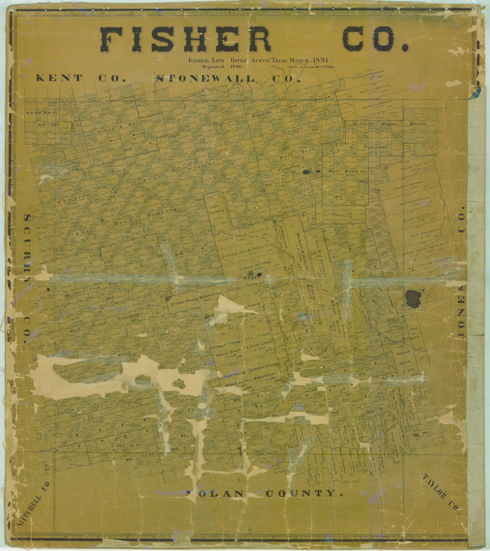
Fisher Co.
-
Map/Doc
78412
-
Collection
General Map Collection
-
Object Dates
1894 (Creation Date)
-
People and Organizations
Texas General Land Office (Publisher)
-
Counties
Fisher
-
Subjects
County
-
Height x Width
45.3 x 40.3 inches
115.1 x 102.4 cm
-
Comments
Help Save Texas History - Adopt Me!
-
Features
Double Mountain Fork of Brazos River
Gypsum Creek
Main Elm Fork of Brazos River
North Alkali Creek
Roby
Plum Creek
Wood Creek
Brazos River
China Creek
Part of: General Map Collection
Scurry County Working Sketch 7

Print $20.00
- Digital $50.00
Scurry County Working Sketch 7
1971
Size 33.5 x 29.0 inches
Map/Doc 63836
Tyler County Sketch File 2

Print $4.00
- Digital $50.00
Tyler County Sketch File 2
Size 6.3 x 5.6 inches
Map/Doc 38615
Carta Hidrografica

Print $20.00
- Digital $50.00
Carta Hidrografica
1897
Size 26.0 x 34.3 inches
Map/Doc 96803
Flight Mission No. DQN-2K, Frame 164, Calhoun County

Print $20.00
- Digital $50.00
Flight Mission No. DQN-2K, Frame 164, Calhoun County
1953
Size 18.7 x 22.5 inches
Map/Doc 84326
Polk County Working Sketch 18

Print $20.00
- Digital $50.00
Polk County Working Sketch 18
1949
Size 25.4 x 23.3 inches
Map/Doc 71633
Upton County Sketch File 45

Print $20.00
- Digital $50.00
Upton County Sketch File 45
1994
Size 11.3 x 8.8 inches
Map/Doc 38933
Map of Mason County

Print $20.00
- Digital $50.00
Map of Mason County
1859
Size 28.4 x 22.4 inches
Map/Doc 3838
Pecos County Working Sketch 88

Print $20.00
- Digital $50.00
Pecos County Working Sketch 88
1963
Size 34.5 x 27.5 inches
Map/Doc 71560
Map of Matagorda County

Print $20.00
- Digital $50.00
Map of Matagorda County
1865
Size 26.9 x 25.0 inches
Map/Doc 3842
Ochiltree County

Print $20.00
- Digital $50.00
Ochiltree County
1878
Size 19.2 x 17.5 inches
Map/Doc 3924

Terry County Rolled Sketch 4

Print $20.00
- Digital $50.00
Terry County Rolled Sketch 4
Size 38.7 x 36.8 inches
Map/Doc 9994
You may also like
Dawson County Sketch File D

Print $20.00
- Digital $50.00
Dawson County Sketch File D
1917
Size 30.0 x 40.3 inches
Map/Doc 10363
General Highway Map, Palo Pinto County, Texas

Print $20.00
General Highway Map, Palo Pinto County, Texas
1940
Size 18.2 x 24.6 inches
Map/Doc 79213
Baylor County Sketch File Z2

Print $40.00
- Digital $50.00
Baylor County Sketch File Z2
Size 28.5 x 31.3 inches
Map/Doc 10913
Flight Mission No. BRA-7M, Frame 21, Jefferson County

Print $20.00
- Digital $50.00
Flight Mission No. BRA-7M, Frame 21, Jefferson County
1953
Size 18.4 x 22.2 inches
Map/Doc 85472
Kenedy County Working Sketch 3

Print $20.00
- Digital $50.00
Kenedy County Working Sketch 3
1903
Size 30.3 x 38.4 inches
Map/Doc 70005
Pecos County Working Sketch 52

Print $20.00
- Digital $50.00
Pecos County Working Sketch 52
1948
Size 46.8 x 32.5 inches
Map/Doc 71524
[Leagues 464-467 and vicinity]
![91649, [Leagues 464-467 and vicinity], Twichell Survey Records](https://historictexasmaps.com/wmedia_w700/maps/91649-1.tif.jpg)
Print $2.00
- Digital $50.00
[Leagues 464-467 and vicinity]
Size 10.6 x 8.1 inches
Map/Doc 91649
Borden County Sketch File 1

Print $6.00
- Digital $50.00
Borden County Sketch File 1
Size 16.2 x 11.0 inches
Map/Doc 14701
Amistad International Reservoir on Rio Grande 104

Print $20.00
- Digital $50.00
Amistad International Reservoir on Rio Grande 104
1950
Size 28.5 x 40.9 inches
Map/Doc 75535
Trails made and routes used by the Fourth U.S. Cavalry under command of General R.S. Mackenzie in its operations against hostile indians in Texas, Indian-Territory (now Oklahoma), New Mexico and Old Mexico during the period of 1871-2-3-4 and 5

Print $20.00
- Digital $50.00
Trails made and routes used by the Fourth U.S. Cavalry under command of General R.S. Mackenzie in its operations against hostile indians in Texas, Indian-Territory (now Oklahoma), New Mexico and Old Mexico during the period of 1871-2-3-4 and 5
1927
Size 37.0 x 34.2 inches
Map/Doc 62973
Bowie County Working Sketch 14

Print $20.00
- Digital $50.00
Bowie County Working Sketch 14
1959
Size 25.7 x 43.2 inches
Map/Doc 67418
Flight Mission No. DQN-3K, Frame 64, Calhoun County

Print $20.00
- Digital $50.00
Flight Mission No. DQN-3K, Frame 64, Calhoun County
1953
Size 16.2 x 16.1 inches
Map/Doc 84355