Liberty County Rolled Sketch O
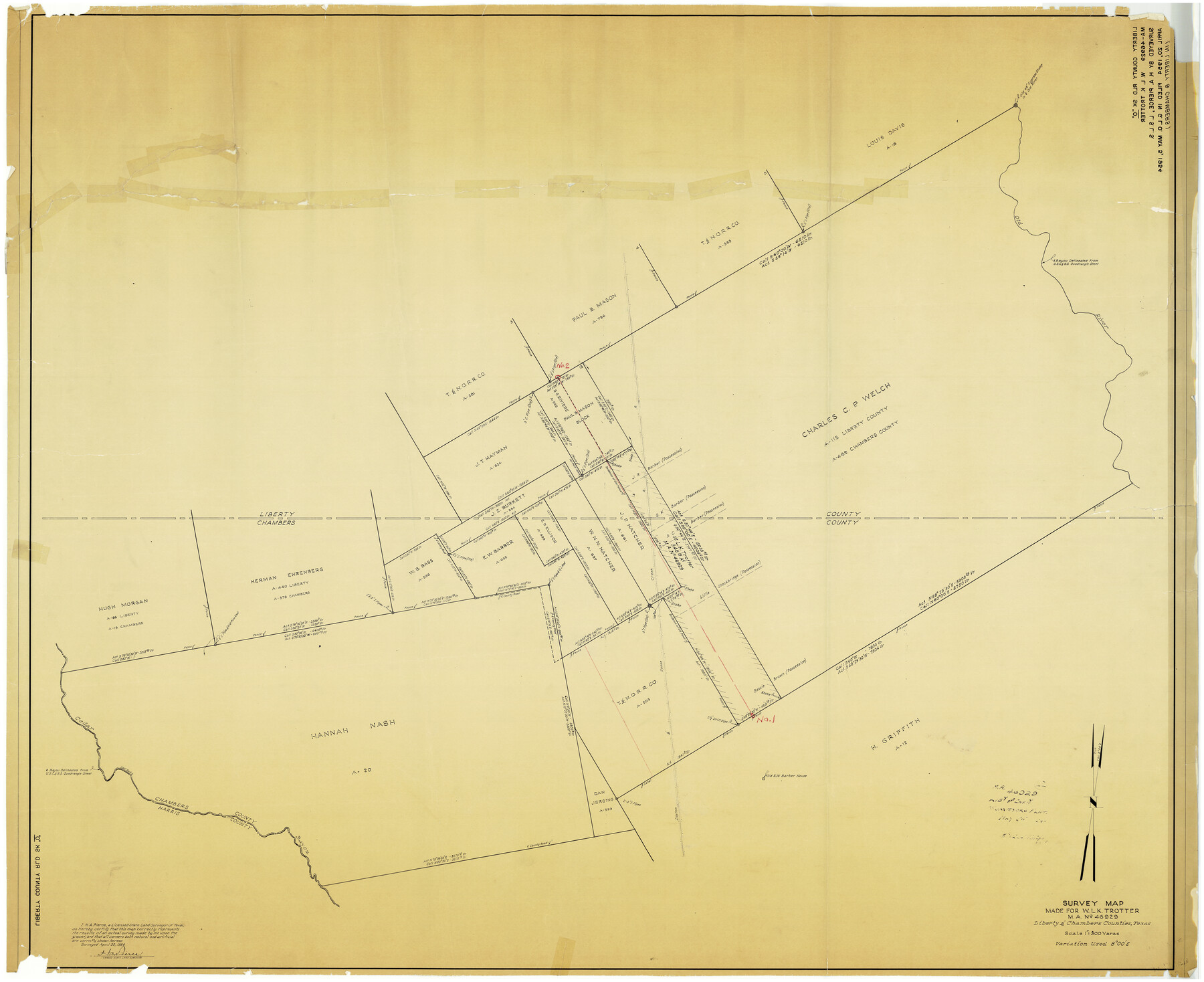
Survey map made for W.L.K. Trotter M.A. no. 46929, Liberty & Chambers Counties, Texas
-
Map/Doc
10720
-
Collection
General Map Collection
-
Object Dates
4/20/1954 (Creation Date)
5/5/1954 (File Date)
-
People and Organizations
H.A. Pierce (Surveyor/Engineer)
-
Counties
Liberty Chambers
-
Subjects
Surveying Rolled Sketch
-
Height x Width
52.3 x 42.8 inches
132.8 x 108.7 cm
-
Medium
blueprint/diazo
Part of: General Map Collection
Ochiltree County Boundary File 8

Print $8.00
- Digital $50.00
Ochiltree County Boundary File 8
Size 11.2 x 8.7 inches
Map/Doc 57716
Dallas County Working Sketch 10

Print $20.00
- Digital $50.00
Dallas County Working Sketch 10
1971
Size 22.6 x 22.7 inches
Map/Doc 68576
Phelps & Ensigns Travellers' Guide, and Map of the United States, containing the roads, distances, steam boat and canal routes & c.

Print $40.00
- Digital $50.00
Phelps & Ensigns Travellers' Guide, and Map of the United States, containing the roads, distances, steam boat and canal routes & c.
1844
Map/Doc 97114
Flight Mission No. CRC-1R, Frame 36, Chambers County

Print $20.00
- Digital $50.00
Flight Mission No. CRC-1R, Frame 36, Chambers County
1956
Size 18.7 x 22.3 inches
Map/Doc 84704
Colorado River, Bay City to Matagorda Sheet 2

Print $40.00
- Digital $50.00
Colorado River, Bay City to Matagorda Sheet 2
1924
Size 86.2 x 32.8 inches
Map/Doc 65260
Flight Mission No. CGI-3N, Frame 132, Cameron County

Print $20.00
- Digital $50.00
Flight Mission No. CGI-3N, Frame 132, Cameron County
1954
Size 18.4 x 22.2 inches
Map/Doc 84605
Goliad County Sketch File 41

Print $20.00
- Digital $50.00
Goliad County Sketch File 41
1958
Size 25.2 x 35.3 inches
Map/Doc 11573
San Jacinto County Working Sketch 3

Print $20.00
- Digital $50.00
San Jacinto County Working Sketch 3
1926
Size 16.7 x 19.7 inches
Map/Doc 63716
Presidio County Rolled Sketch 30

Print $40.00
- Digital $50.00
Presidio County Rolled Sketch 30
Size 40.8 x 84.9 inches
Map/Doc 9767
Baylor County Sketch File 13

Print $4.00
- Digital $50.00
Baylor County Sketch File 13
1856
Size 13.5 x 8.5 inches
Map/Doc 14179
Map of Cameron County

Print $20.00
- Digital $50.00
Map of Cameron County
1873
Size 42.2 x 22.5 inches
Map/Doc 3364
Baylor County Sketch File 1

Print $6.00
- Digital $50.00
Baylor County Sketch File 1
Size 17.5 x 11.4 inches
Map/Doc 14117
You may also like
Flight Mission No. DQO-8K, Frame 144, Galveston County

Print $20.00
- Digital $50.00
Flight Mission No. DQO-8K, Frame 144, Galveston County
1952
Size 18.7 x 22.5 inches
Map/Doc 85206
Coryell County Working Sketch 18

Print $20.00
- Digital $50.00
Coryell County Working Sketch 18
1965
Size 24.6 x 34.3 inches
Map/Doc 68225
General Highway Map, Gray County, Texas

Print $20.00
General Highway Map, Gray County, Texas
1961
Size 18.1 x 24.7 inches
Map/Doc 79483
Gulf of Mexico

Print $20.00
- Digital $50.00
Gulf of Mexico
1900
Size 18.2 x 28.0 inches
Map/Doc 72648
Val Verde County, Texas, E. L. & R. R. Ry. Block D7 showing beginning point and direction of certain surveys

Print $20.00
- Digital $50.00
Val Verde County, Texas, E. L. & R. R. Ry. Block D7 showing beginning point and direction of certain surveys
1937
Size 22.1 x 17.0 inches
Map/Doc 91950
Archer County Sketch File 30

Print $40.00
- Digital $50.00
Archer County Sketch File 30
1896
Size 20.6 x 18.5 inches
Map/Doc 10838
Northeast Part Pecos County

Print $20.00
- Digital $50.00
Northeast Part Pecos County
1975
Size 36.9 x 43.4 inches
Map/Doc 95611
Crockett County Rolled Sketch 82

Print $20.00
- Digital $50.00
Crockett County Rolled Sketch 82
1959
Size 22.4 x 21.2 inches
Map/Doc 5622
Jefferson County Rolled Sketch 49

Print $40.00
- Digital $50.00
Jefferson County Rolled Sketch 49
1963
Size 30.6 x 57.5 inches
Map/Doc 46415
Trinity County Working Sketch 17

Print $20.00
- Digital $50.00
Trinity County Working Sketch 17
1978
Size 24.0 x 26.6 inches
Map/Doc 69466
Flight Mission No. DQN-4K, Frame 8, Calhoun County

Print $20.00
- Digital $50.00
Flight Mission No. DQN-4K, Frame 8, Calhoun County
1953
Size 18.8 x 22.5 inches
Map/Doc 84373
Sketch from old map (authority unknown) showing a portion of the Rio Grande River and harbor of Brazos Santiago, Texas

Print $20.00
- Digital $50.00
Sketch from old map (authority unknown) showing a portion of the Rio Grande River and harbor of Brazos Santiago, Texas
1887
Size 18.4 x 24.1 inches
Map/Doc 73004