Cherokee County Sketch File 23
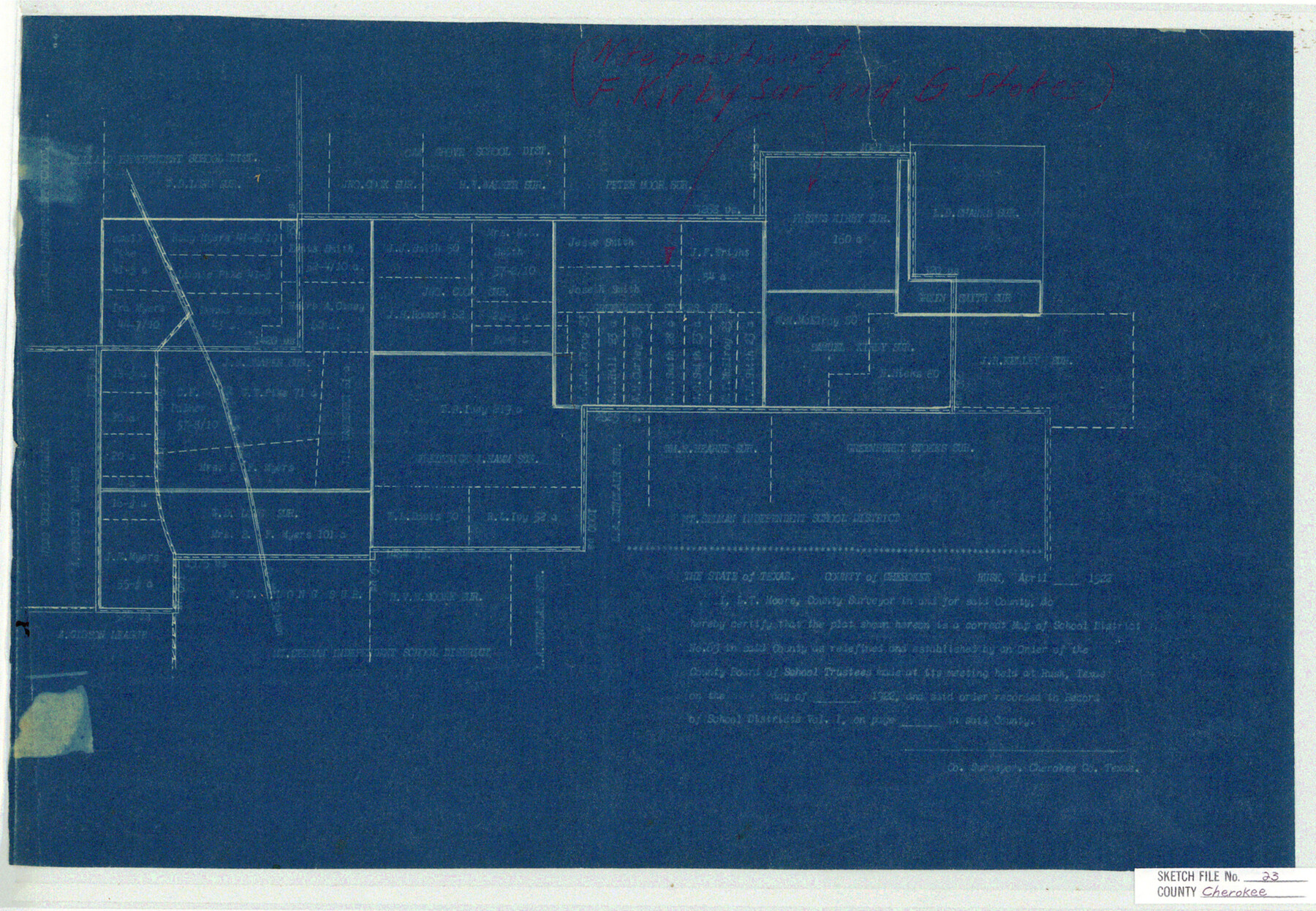
[Map of School District No. 69]
-
Map/Doc
11073
-
Collection
General Map Collection
-
Object Dates
1922 (Creation Date)
-
People and Organizations
L.T. Moore (Surveyor/Engineer)
-
Counties
Cherokee
-
Subjects
Surveying Sketch File
-
Height x Width
12.8 x 18.5 inches
32.5 x 47.0 cm
-
Medium
blueprint/diazo
Part of: General Map Collection
Flight Mission No. BQR-13K, Frame 28, Brazoria County

Print $20.00
- Digital $50.00
Flight Mission No. BQR-13K, Frame 28, Brazoria County
1952
Size 18.6 x 22.4 inches
Map/Doc 84076
Lamb County Sketch File 16

Print $4.00
- Digital $50.00
Lamb County Sketch File 16
1929
Size 11.2 x 8.8 inches
Map/Doc 29379
Parker County Working Sketch 6

Print $20.00
- Digital $50.00
Parker County Working Sketch 6
1923
Map/Doc 71456
Franklin County Boundary File 1

Print $8.00
- Digital $50.00
Franklin County Boundary File 1
Size 12.9 x 8.1 inches
Map/Doc 53569
Galveston County NRC Article 33.136 Location Key Sheet

Print $20.00
- Digital $50.00
Galveston County NRC Article 33.136 Location Key Sheet
1994
Size 27.0 x 21.8 inches
Map/Doc 77019
Starr County Sketch File 46

Print $20.00
- Digital $50.00
Starr County Sketch File 46
1949
Size 23.3 x 26.6 inches
Map/Doc 12343
Wilson County Rolled Sketch 4

Print $20.00
- Digital $50.00
Wilson County Rolled Sketch 4
Size 27.1 x 29.6 inches
Map/Doc 8370
Kimble County Rolled Sketch 29

Print $20.00
- Digital $50.00
Kimble County Rolled Sketch 29
Size 27.5 x 31.0 inches
Map/Doc 6519
Lampasas County Rolled Sketch 1

Print $20.00
- Digital $50.00
Lampasas County Rolled Sketch 1
1975
Size 22.0 x 28.2 inches
Map/Doc 6564

Comanche County Working Sketch 5

Print $20.00
- Digital $50.00
Comanche County Working Sketch 5
1919
Size 31.8 x 28.9 inches
Map/Doc 68139
Trinity County Sketch File 30A

Print $20.00
- Digital $50.00
Trinity County Sketch File 30A
1890
Size 18.0 x 17.6 inches
Map/Doc 12489
You may also like
Report of a resurvey of Texas & Pacific Ry. Lands in the 80 mile reservation made in 1930-31 for Kloh, Rumsey, and Abrams by W. J. Powell, Consulting Eng.

Print $77.00
- Digital $50.00
Report of a resurvey of Texas & Pacific Ry. Lands in the 80 mile reservation made in 1930-31 for Kloh, Rumsey, and Abrams by W. J. Powell, Consulting Eng.
1931
Size 11.3 x 8.8 inches
Map/Doc 2247
Johnson County Sketch File 15

Print $2.00
- Digital $50.00
Johnson County Sketch File 15
1881
Size 8.1 x 7.3 inches
Map/Doc 28455

Cherokee County Sketch File 14

Print $4.00
- Digital $50.00
Cherokee County Sketch File 14
1860
Size 8.0 x 5.9 inches
Map/Doc 18147
Pecos County Sketch File 27

Print $20.00
- Digital $50.00
Pecos County Sketch File 27
1900
Size 18.1 x 14.5 inches
Map/Doc 12165
Fannin County Boundary File 3

Print $36.00
- Digital $50.00
Fannin County Boundary File 3
Size 13.2 x 8.8 inches
Map/Doc 53295
Hardin County Working Sketch 40

Print $20.00
- Digital $50.00
Hardin County Working Sketch 40
1988
Size 23.0 x 14.4 inches
Map/Doc 63439
Schleicher County Sketch File 32

Print $22.00
- Digital $50.00
Schleicher County Sketch File 32
1941
Size 9.1 x 13.3 inches
Map/Doc 36532
Kimble County

Print $40.00
- Digital $50.00
Kimble County
1930
Size 43.8 x 49.2 inches
Map/Doc 73207
Stonewall County Working Sketch 12

Print $20.00
- Digital $50.00
Stonewall County Working Sketch 12
1950
Size 27.9 x 27.9 inches
Map/Doc 62319
The Rand-McNally Official Railway Guide Map of the United States with portions of the Dominion of Canada, the Republic of Mexico, and the West Indies

Print $20.00
- Digital $50.00
The Rand-McNally Official Railway Guide Map of the United States with portions of the Dominion of Canada, the Republic of Mexico, and the West Indies
1927
Size 31.1 x 43.5 inches
Map/Doc 95864
[Subdivision of Crockett County School Land Lgs. 214-217]
![90106, [Subdivision of Crockett County School Land Lgs. 214-217], Twichell Survey Records](https://historictexasmaps.com/wmedia_w700/maps/90106-1.tif.jpg)
Print $2.00
- Digital $50.00
[Subdivision of Crockett County School Land Lgs. 214-217]
Size 12.4 x 8.5 inches
Map/Doc 90106