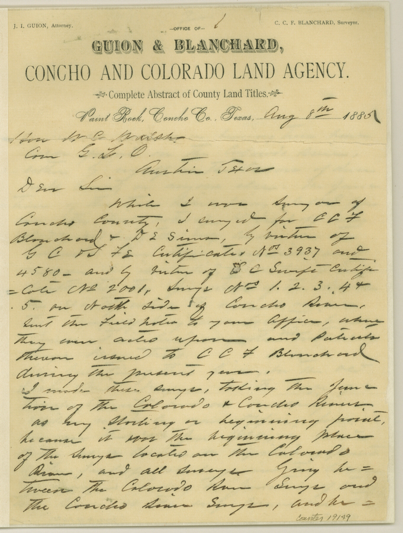
Concho County Sketch File 24
[Letter regarding surveys north of Concho]
-
Map/Doc
19149
-
Collection
General Map Collection
-
Object Dates
1885/8/15 (Creation Date)
-
People and Organizations
Jno. I. Guion (Surveyor/Engineer)
-
Counties
Concho Runnels
-
Subjects
Surveying Sketch File
-
Height x Width
11.1 x 8.4 inches
28.2 x 21.3 cm
-
Medium
paper, manuscript
-
Features
Colorado River
Concho River
Part of: General Map Collection
Maverick County Working Sketch 8

Print $40.00
- Digital $50.00
Maverick County Working Sketch 8
1959
Size 50.3 x 37.7 inches
Map/Doc 70900
Palo Pinto County

Print $20.00
- Digital $50.00
Palo Pinto County
1898
Size 44.8 x 38.0 inches
Map/Doc 66964
Stephens County Working Sketch 30

Print $20.00
- Digital $50.00
Stephens County Working Sketch 30
1977
Size 26.4 x 15.7 inches
Map/Doc 63973
Collingsworth County

Print $20.00
- Digital $50.00
Collingsworth County
1899
Size 42.7 x 39.7 inches
Map/Doc 4915
Lay's Map of the United States

Print $40.00
- Digital $50.00
Lay's Map of the United States
Size 55.0 x 61.7 inches
Map/Doc 95693
Menard County Sketch File 25b

Print $6.00
- Digital $50.00
Menard County Sketch File 25b
1936
Size 14.2 x 8.6 inches
Map/Doc 31557
Palo Pinto County

Print $20.00
- Digital $50.00
Palo Pinto County
1896
Size 27.2 x 22.1 inches
Map/Doc 3937
Rusk County Sketch File 33

Print $10.00
Rusk County Sketch File 33
1949
Size 11.5 x 8.8 inches
Map/Doc 35568
Harris County Working Sketch 30

Print $20.00
- Digital $50.00
Harris County Working Sketch 30
1935
Size 25.9 x 28.0 inches
Map/Doc 65922
Mills County Sketch File 18A

Print $20.00
- Digital $50.00
Mills County Sketch File 18A
1913
Size 26.5 x 18.4 inches
Map/Doc 12093
Tyler County Working Sketch 9

Print $20.00
- Digital $50.00
Tyler County Working Sketch 9
1937
Size 25.7 x 27.1 inches
Map/Doc 69479
Hall County Working Sketch 4

Print $20.00
- Digital $50.00
Hall County Working Sketch 4
1923
Size 29.0 x 19.7 inches
Map/Doc 63332
You may also like
[Capitol Leagues along New Mexico Line]
![90766, [Capitol Leagues along New Mexico Line], Twichell Survey Records](https://historictexasmaps.com/wmedia_w700/maps/90766-1.tif.jpg)
Print $20.00
- Digital $50.00
[Capitol Leagues along New Mexico Line]
Size 8.2 x 22.7 inches
Map/Doc 90766
Old Miscellaneous File 20

Print $16.00
- Digital $50.00
Old Miscellaneous File 20
1913
Size 13.6 x 7.9 inches
Map/Doc 75575
Eastland County Boundary File 13

Print $68.00
- Digital $50.00
Eastland County Boundary File 13
Size 8.0 x 3.7 inches
Map/Doc 52785
Bosque County Rolled Sketch 2

Print $20.00
- Digital $50.00
Bosque County Rolled Sketch 2
Size 30.2 x 18.1 inches
Map/Doc 5160
Maverick County Working Sketch 9

Print $20.00
- Digital $50.00
Maverick County Working Sketch 9
1959
Size 43.8 x 42.2 inches
Map/Doc 70901
Flight Mission No. DAG-24K, Frame 157, Matagorda County

Print $20.00
- Digital $50.00
Flight Mission No. DAG-24K, Frame 157, Matagorda County
1953
Size 18.6 x 22.5 inches
Map/Doc 86571
Right of Way and Track Map, the Missouri, Kansas and Texas Ry. of Texas - Henrietta Division

Print $20.00
- Digital $50.00
Right of Way and Track Map, the Missouri, Kansas and Texas Ry. of Texas - Henrietta Division
1918
Size 11.9 x 26.8 inches
Map/Doc 64753
The Magic Valley of the Lower Rio Grande

The Magic Valley of the Lower Rio Grande
1926
Map/Doc 96733
Flight Mission No. DCL-7C, Frame 62, Kenedy County

Print $20.00
- Digital $50.00
Flight Mission No. DCL-7C, Frame 62, Kenedy County
1943
Size 15.4 x 15.3 inches
Map/Doc 86050
Liberty County Rolled Sketch JP2

Print $40.00
- Digital $50.00
Liberty County Rolled Sketch JP2
1935
Size 51.8 x 12.8 inches
Map/Doc 10663
Flight Mission No. DQO-3K, Frame 25, Galveston County

Print $20.00
- Digital $50.00
Flight Mission No. DQO-3K, Frame 25, Galveston County
1952
Size 18.8 x 22.4 inches
Map/Doc 85066
Portion of States Submerged Area in Matagorda Bay

Print $20.00
- Digital $50.00
Portion of States Submerged Area in Matagorda Bay
1923
Size 12.7 x 13.5 inches
Map/Doc 2956