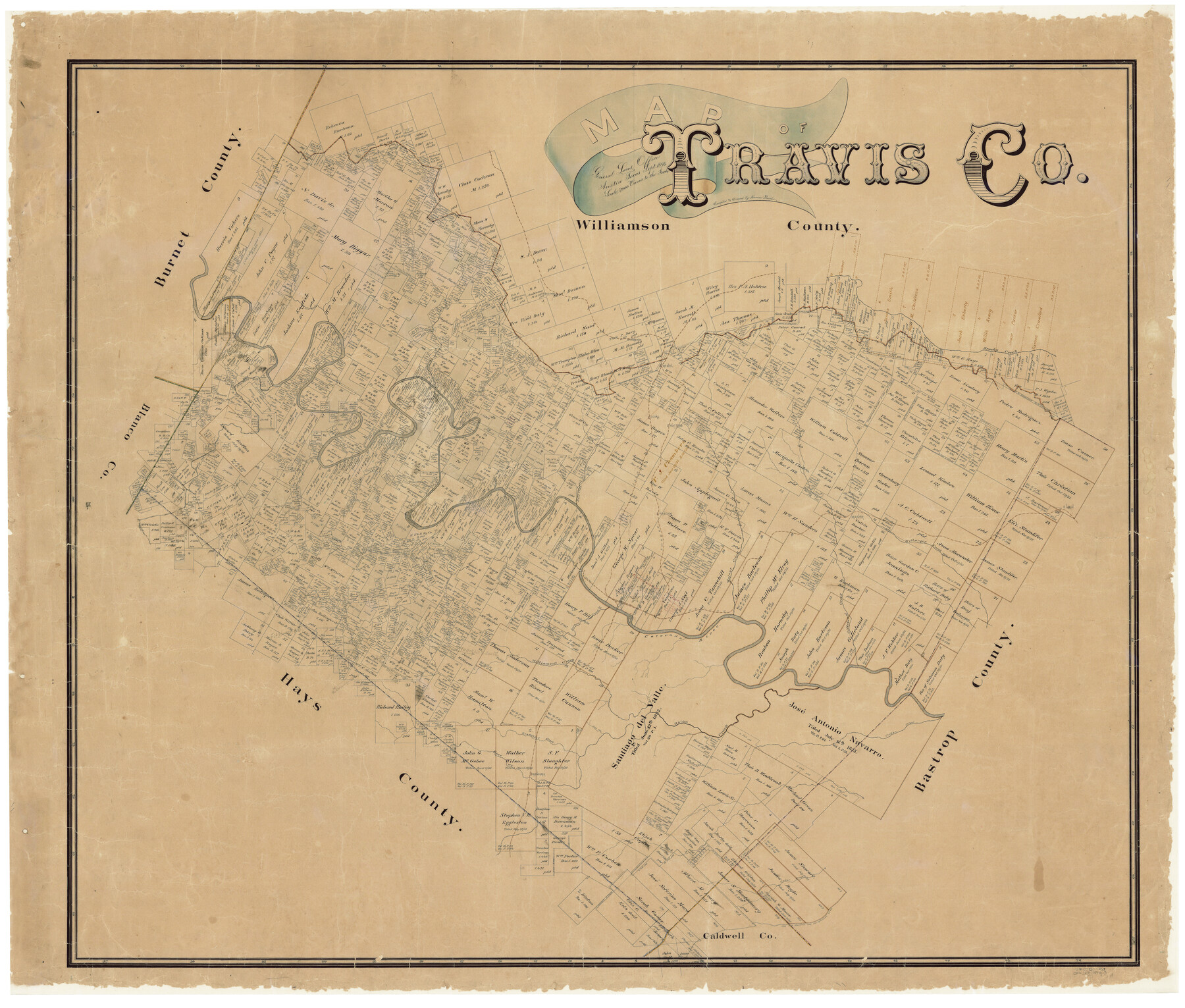
Map of Travis County
-
Map/Doc
16904
-
Collection
General Map Collection
-
Object Dates
9/1894 (Creation Date)
-
People and Organizations
Herman Pressler (Draftsman)
-
Counties
Travis
-
Subjects
County
-
Height x Width
49.8 x 58.8 inches
126.5 x 149.4 cm
-
Comments
Conservation funded in 2001 with donation from Frost Bank.
-
Features
A&NW
Brushy Creek
Nacogdoches Road
Old San Antonio Road
Bear Creek
Manchaca
Rock Spring Branch [of Onion Creek]
Cedar Creek
Cedar Valley Post Office
Cougar Branch [of Bull Creek]
H&TC
Cottonmouth Creek
Onion Creek
Boggy Creek
Slaughter Creek
Gilleland Creek
Williamson Creek
Barton Creek
Harrison Branch [of Colorado River]
Jolly Creek
Cat Hollow Creek
Cypress Creek
Basin Branch [of Pedernales River]
Clear Creek
I&GN
[Road] to Oak Hill and Austin
Oak Hill Road
Austin Road
[Road] to Hammett Crossing
[Road] to Dripping Springs
Grape Creek
Fitzhugh Post Office
Cedar Valley Post Office
McNeil
Linn Creek
Elgin
Hurst's Creek
Colorado River
Flat Creek
Turner's Branch [of Pedernales River]
Duval
Watters
Manor
Pedernales River
Red Bluff Creek
Deep Creek
Cummings
Cedar Park
Cow Creek
Cherry Hollow Creek
Bloody Hollow Creek
Hancock
Bull Creek
Devils Cañon
Turkey Creek
Dead Man's Hole Creek
Little Barton Creek
Nep's Branch [of Barton Creek]
Bee Creek
Dam Railroad
Shoal Creek
Austin
Walnut Creek
Wilbarger Creek
Rocky Creek
Long Branch [of Barton Creek]
-
URLs
https://medium.com/save-texas-history/map-of-travis-co-1894-by-herman-pressler-9fc6a25fd995#.fmh7tfkot
Part of: General Map Collection
Map of Silverton, County Seat of Briscoe County, Texas

Print $20.00
- Digital $50.00
Map of Silverton, County Seat of Briscoe County, Texas
1891
Size 24.3 x 19.8 inches
Map/Doc 4832
Brewster County Working Sketch 59

Print $20.00
- Digital $50.00
Brewster County Working Sketch 59
1955
Size 24.6 x 19.0 inches
Map/Doc 67660
Atascosa County Boundary File 6

Print $34.00
- Digital $50.00
Atascosa County Boundary File 6
Size 9.1 x 23.0 inches
Map/Doc 50205
Marion County Working Sketch 25

Print $20.00
- Digital $50.00
Marion County Working Sketch 25
1968
Size 24.8 x 28.1 inches
Map/Doc 70801
Tarrant County Working Sketch 14

Print $20.00
- Digital $50.00
Tarrant County Working Sketch 14
1989
Size 26.5 x 31.0 inches
Map/Doc 62431
Concho County Sketch File 26

Print $6.00
- Digital $50.00
Concho County Sketch File 26
1885
Size 11.5 x 9.0 inches
Map/Doc 19159
Galveston to Rio Grande

Print $20.00
- Digital $50.00
Galveston to Rio Grande
1967
Size 44.4 x 37.0 inches
Map/Doc 69955
Reagan County Working Sketch 25

Print $20.00
- Digital $50.00
Reagan County Working Sketch 25
1958
Size 45.8 x 42.8 inches
Map/Doc 71867
University Land Field Notes for Block L in El Paso County

University Land Field Notes for Block L in El Paso County
Map/Doc 81725
Fractional Township No. 7 South Range No. 4 East of the Indian Meridian, Indian Territory

Print $20.00
- Digital $50.00
Fractional Township No. 7 South Range No. 4 East of the Indian Meridian, Indian Territory
1898
Size 19.3 x 24.4 inches
Map/Doc 75207
Haskell County Rolled Sketch 16

Print $20.00
- Digital $50.00
Haskell County Rolled Sketch 16
1991
Size 45.3 x 39.4 inches
Map/Doc 9148
Ward County Working Sketch Graphic Index - sheet A

Print $40.00
- Digital $50.00
Ward County Working Sketch Graphic Index - sheet A
1932
Size 30.8 x 52.8 inches
Map/Doc 76731
You may also like
Ochiltree County

Print $20.00
- Digital $50.00
Ochiltree County
1958
Size 43.4 x 34.4 inches
Map/Doc 73253
Jefferson County Working Sketch 14

Print $20.00
- Digital $50.00
Jefferson County Working Sketch 14
1948
Size 30.3 x 25.8 inches
Map/Doc 66557
Wilson County Working Sketch 8

Print $20.00
- Digital $50.00
Wilson County Working Sketch 8
1975
Size 36.5 x 31.9 inches
Map/Doc 72588
Harrison County

Print $20.00
- Digital $50.00
Harrison County
1920
Size 47.7 x 42.9 inches
Map/Doc 4972
Oldham County Rolled Sketch 11

Print $40.00
- Digital $50.00
Oldham County Rolled Sketch 11
Size 48.6 x 39.9 inches
Map/Doc 10641
Flight Mission No. DQO-6K, Frame 32, Galveston County

Print $20.00
- Digital $50.00
Flight Mission No. DQO-6K, Frame 32, Galveston County
1952
Size 18.7 x 22.4 inches
Map/Doc 85098
DeWitt County Working Sketch Graphic Index

Print $20.00
- Digital $50.00
DeWitt County Working Sketch Graphic Index
1920
Size 39.7 x 46.7 inches
Map/Doc 76522
Travis County Appraisal District Plat Map 2_2313

Print $20.00
- Digital $50.00
Travis County Appraisal District Plat Map 2_2313
Size 21.4 x 26.3 inches
Map/Doc 94215
Flight Mission No. DAG-21K, Frame 124, Matagorda County

Print $20.00
- Digital $50.00
Flight Mission No. DAG-21K, Frame 124, Matagorda County
1952
Size 18.5 x 22.4 inches
Map/Doc 86450
Surveys in the Milam District at the fork of the Yegua and Brazos Rivers and on the Leon River

Print $2.00
- Digital $50.00
Surveys in the Milam District at the fork of the Yegua and Brazos Rivers and on the Leon River
1846
Size 9.2 x 16.0 inches
Map/Doc 254
Hunt County Sketch File 4a

Print $4.00
- Digital $50.00
Hunt County Sketch File 4a
1859
Size 12.6 x 8.2 inches
Map/Doc 27089
Maps & Lists Showing Prison Lands (Oil & Gas) Leased as of June 1955

Digital $50.00
Maps & Lists Showing Prison Lands (Oil & Gas) Leased as of June 1955
Size 11.4 x 7.3 inches
Map/Doc 62868