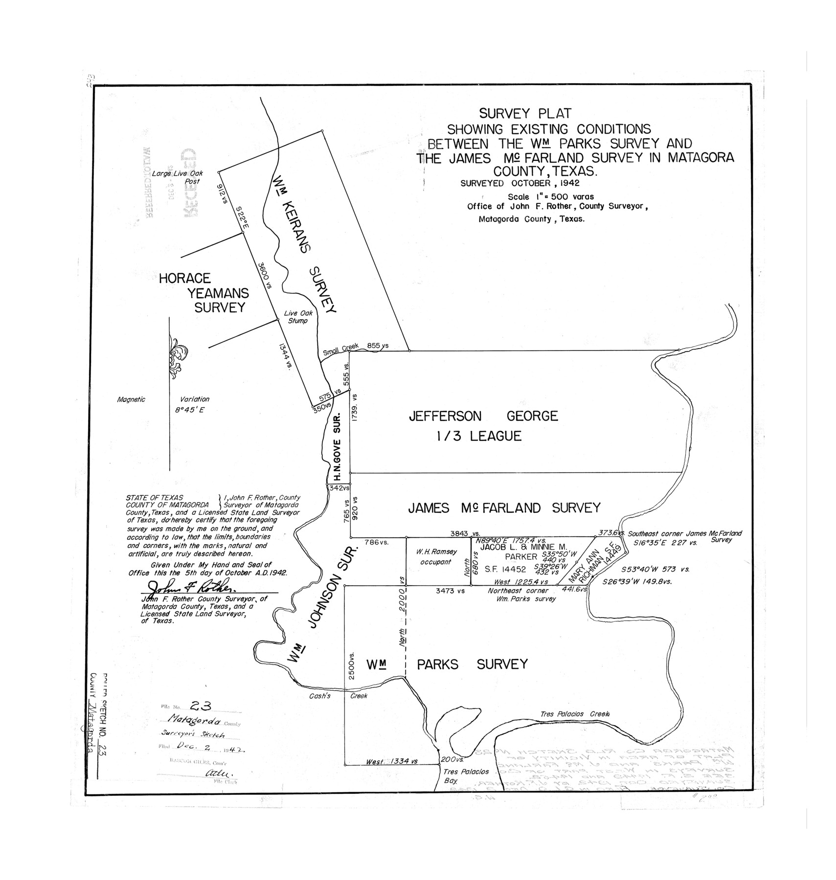
Matagorda County Rolled Sketch 23
Survey plat showing existing conditions between the Wm. Parks survey and the James McFarland survey in Matagorda County, Texas
-
Map/Doc
6690
-
Collection
General Map Collection
-
Object Dates
1942 (Creation Date)
1942/12/2 (File Date)
-
People and Organizations
John F. Rother (Surveyor/Engineer)
-
Counties
Matagorda
-
Subjects
Surveying Rolled Sketch
-
Height x Width
25.0 x 23.8 inches
63.5 x 60.5 cm
-
Scale
1" = 500 varas
Part of: General Map Collection
Van Zandt County Sketch File 19

Print $4.00
- Digital $50.00
Van Zandt County Sketch File 19
1858
Size 9.7 x 7.7 inches
Map/Doc 39422
South Montgomery County, Woodlands Chamber of Commerce Street Map

South Montgomery County, Woodlands Chamber of Commerce Street Map
Size 50.0 x 37.9 inches
Map/Doc 94363
Coryell County Working Sketch 26

Print $20.00
- Digital $50.00
Coryell County Working Sketch 26
1988
Size 30.7 x 30.6 inches
Map/Doc 68233
Copy of Surveyor's Field Book, Morris Browning - In Blocks 7, 5 & 4, I&GNRRCo., Hutchinson and Carson Counties, Texas

Print $2.00
- Digital $50.00
Copy of Surveyor's Field Book, Morris Browning - In Blocks 7, 5 & 4, I&GNRRCo., Hutchinson and Carson Counties, Texas
1888
Size 6.8 x 8.8 inches
Map/Doc 62274
Crane County Rolled Sketch 28

Print $40.00
- Digital $50.00
Crane County Rolled Sketch 28
2020
Size 35.7 x 51.2 inches
Map/Doc 96434
[Surveys along the Leona and Frio Rivers]
![16, [Surveys along the Leona and Frio Rivers], General Map Collection](https://historictexasmaps.com/wmedia_w700/maps/16.tif.jpg)
Print $20.00
- Digital $50.00
[Surveys along the Leona and Frio Rivers]
1841
Size 12.4 x 13.1 inches
Map/Doc 16
Bell County Sketch File 23

Print $4.00
- Digital $50.00
Bell County Sketch File 23
1873
Size 8.2 x 12.8 inches
Map/Doc 14414
Carte de la Louisiane et du Cours du Mississipi

Print $20.00
- Digital $50.00
Carte de la Louisiane et du Cours du Mississipi
Size 21.7 x 28.6 inches
Map/Doc 95161
Crosby County Sketch File 2

Print $22.00
- Digital $50.00
Crosby County Sketch File 2
Size 8.5 x 9.9 inches
Map/Doc 19991
Irion County Working Sketch 17

Print $20.00
- Digital $50.00
Irion County Working Sketch 17
1983
Size 37.4 x 41.6 inches
Map/Doc 66426
Map of the State of Texas from the Latest Authorities

Print $20.00
- Digital $50.00
Map of the State of Texas from the Latest Authorities
1853
Size 14.2 x 17.4 inches
Map/Doc 89221
Hardin County Working Sketch 24

Print $20.00
- Digital $50.00
Hardin County Working Sketch 24
1950
Size 15.3 x 11.9 inches
Map/Doc 63422
You may also like
Flight Mission No. CLL-1N, Frame 103, Willacy County

Print $20.00
- Digital $50.00
Flight Mission No. CLL-1N, Frame 103, Willacy County
1954
Size 18.4 x 22.1 inches
Map/Doc 87037
Donley County Working Sketch 5

Print $40.00
- Digital $50.00
Donley County Working Sketch 5
1957
Size 54.8 x 32.2 inches
Map/Doc 62185
Flight Mission No. BQY-4M, Frame 34, Harris County

Print $20.00
- Digital $50.00
Flight Mission No. BQY-4M, Frame 34, Harris County
1953
Size 18.6 x 22.4 inches
Map/Doc 85249
Galveston County Sketch File 12

Print $6.00
- Digital $50.00
Galveston County Sketch File 12
1886
Size 15.7 x 11.4 inches
Map/Doc 23380
Mrs. Alex A. Slaughter Ranch Hockley County, Texas

Print $20.00
- Digital $50.00
Mrs. Alex A. Slaughter Ranch Hockley County, Texas
Size 26.2 x 19.7 inches
Map/Doc 92237
Val Verde Co.

Print $20.00
- Digital $50.00
Val Verde Co.
1908
Size 40.5 x 38.4 inches
Map/Doc 63099
Travis County Sketch File 58

Print $14.00
- Digital $50.00
Travis County Sketch File 58
1948
Size 11.4 x 8.9 inches
Map/Doc 38406
Howard County Rolled Sketch 8

Print $20.00
- Digital $50.00
Howard County Rolled Sketch 8
Size 43.0 x 18.4 inches
Map/Doc 6238
Willacy County

Print $20.00
- Digital $50.00
Willacy County
1921
Size 25.2 x 32.2 inches
Map/Doc 73325
Refugio County NRC Article 33.136 Sketch 4

Print $46.00
- Digital $50.00
Refugio County NRC Article 33.136 Sketch 4
2014
Size 18.0 x 24.0 inches
Map/Doc 94491

Frio County Rolled Sketch 28

Print $20.00
- Digital $50.00
Frio County Rolled Sketch 28
2014
Size 36.3 x 24.7 inches
Map/Doc 97420