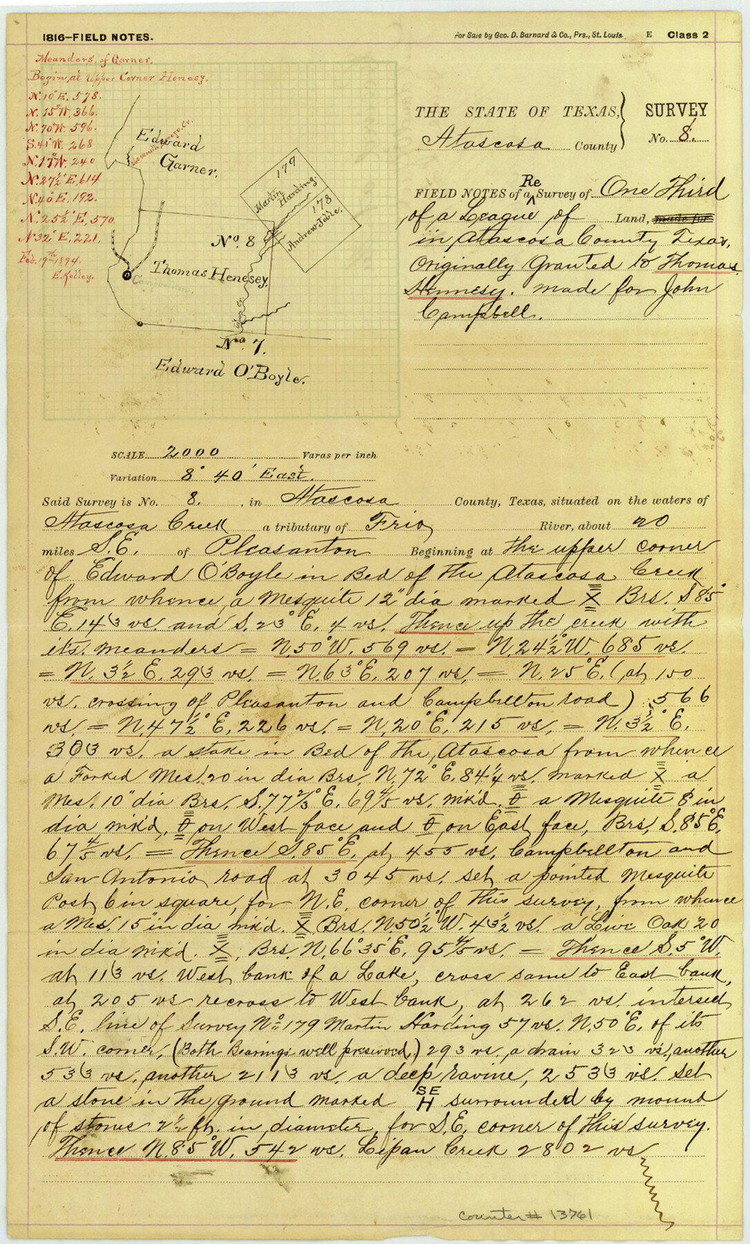
Atascosa County Sketch File 8a
[Field notes and plat of a resurvey of the Thomas Hennesy 1/3 League made for John Campbell]
-
Map/Doc
13761
-
Collection
General Map Collection
-
Object Dates
1894/2/15 (Survey Date)
1894/2/16 (Survey Date)
1894/6/22 (File Date)
-
People and Organizations
Emeil Kelley (Surveyor/Engineer)
Tom Brown (Chainman/Field Personnel)
Louis Tejedo (Chainman/Field Personnel)
J. Kerr (Chainman/Field Personnel)
-
Counties
Atascosa
-
Subjects
Surveying Sketch File
-
Height x Width
13.9 x 8.4 inches
35.3 x 21.3 cm
-
Medium
paper, manuscript
-
Scale
1" = 2000 varas
-
Features
Atascosa Creek
Pleasanton and Campbellton Road
Pleasanton Road
Campbellton Road
Campbellton and San Antonio Road
San Antonio Road
Lipan Creek
Part of: General Map Collection
Stephens County Boundary File 6

Print $12.00
- Digital $50.00
Stephens County Boundary File 6
Size 13.0 x 8.5 inches
Map/Doc 58901
Flight Mission No. CRC-3R, Frame 167, Chambers County

Print $20.00
- Digital $50.00
Flight Mission No. CRC-3R, Frame 167, Chambers County
1956
Size 18.7 x 22.3 inches
Map/Doc 84849
Duval County Working Sketch 29

Print $20.00
- Digital $50.00
Duval County Working Sketch 29
1948
Size 28.9 x 31.5 inches
Map/Doc 68753
Real County Working Sketch Graphic Index, Sheet 1 (Sketches 1 to 42)

Print $20.00
- Digital $50.00
Real County Working Sketch Graphic Index, Sheet 1 (Sketches 1 to 42)
1972
Size 42.9 x 31.0 inches
Map/Doc 76678
Matagorda County Sketch File 7a

Print $8.00
- Digital $50.00
Matagorda County Sketch File 7a
1890
Size 14.2 x 8.9 inches
Map/Doc 30740
Tarrant County Boundary File 6

Print $70.00
- Digital $50.00
Tarrant County Boundary File 6
2004
Size 11.0 x 8.5 inches
Map/Doc 83178
Flight Mission No. CRC-3R, Frame 95, Chambers County

Print $20.00
- Digital $50.00
Flight Mission No. CRC-3R, Frame 95, Chambers County
1956
Size 18.6 x 22.4 inches
Map/Doc 84833
Outer Continental Shelf Leasing Maps (Louisiana Offshore Operations)

Print $20.00
- Digital $50.00
Outer Continental Shelf Leasing Maps (Louisiana Offshore Operations)
1955
Size 17.2 x 9.4 inches
Map/Doc 76081
Burleson County State Real Property Sketch 1

Print $80.00
- Digital $50.00
Burleson County State Real Property Sketch 1
2003
Size 37.0 x 53.6 inches
Map/Doc 81907

Edwards County Working Sketch 37

Print $20.00
- Digital $50.00
Edwards County Working Sketch 37
1948
Size 23.1 x 35.5 inches
Map/Doc 68913
The Latest Map of Texas
Print $20.00
- Digital $50.00
The Latest Map of Texas
1889
Size 32.0 x 34.0 inches
Map/Doc 93422
You may also like
Aransas County Rolled Sketch 19

Print $20.00
- Digital $50.00
Aransas County Rolled Sketch 19
1979
Size 24.8 x 36.7 inches
Map/Doc 82559
The Official Map of the City of El Paso, State of Texas

Print $20.00
The Official Map of the City of El Paso, State of Texas
1889
Size 42.2 x 50.5 inches
Map/Doc 89615
Wood County Working Sketch 23

Print $40.00
- Digital $50.00
Wood County Working Sketch 23
1962
Size 54.9 x 43.5 inches
Map/Doc 78230
Flight Mission No. CLL-1N, Frame 19, Willacy County

Print $20.00
- Digital $50.00
Flight Mission No. CLL-1N, Frame 19, Willacy County
1954
Size 18.3 x 22.1 inches
Map/Doc 87006

Flight Mission No. CUG-3P, Frame 11, Kleberg County

Print $20.00
- Digital $50.00
Flight Mission No. CUG-3P, Frame 11, Kleberg County
1956
Size 18.5 x 22.2 inches
Map/Doc 86221
Bell County Sketch File 29

Print $4.00
- Digital $50.00
Bell County Sketch File 29
1874
Size 13.1 x 8.1 inches
Map/Doc 14439
Montgomery County Working Sketch 58

Print $40.00
- Digital $50.00
Montgomery County Working Sketch 58
1962
Size 39.1 x 51.0 inches
Map/Doc 71165
Titus County Boundary File 2

Print $6.00
- Digital $50.00
Titus County Boundary File 2
Size 7.7 x 6.7 inches
Map/Doc 59297
Roberts County Boundary File 2a

Print $10.00
- Digital $50.00
Roberts County Boundary File 2a
Size 9.5 x 6.4 inches
Map/Doc 58339
Runnels County Sketch File E

Print $6.00
Runnels County Sketch File E
1895
Size 12.7 x 8.3 inches
Map/Doc 35481
Erath County Sketch File 13a

Print $6.00
- Digital $50.00
Erath County Sketch File 13a
1872
Size 10.3 x 8.2 inches
Map/Doc 22287