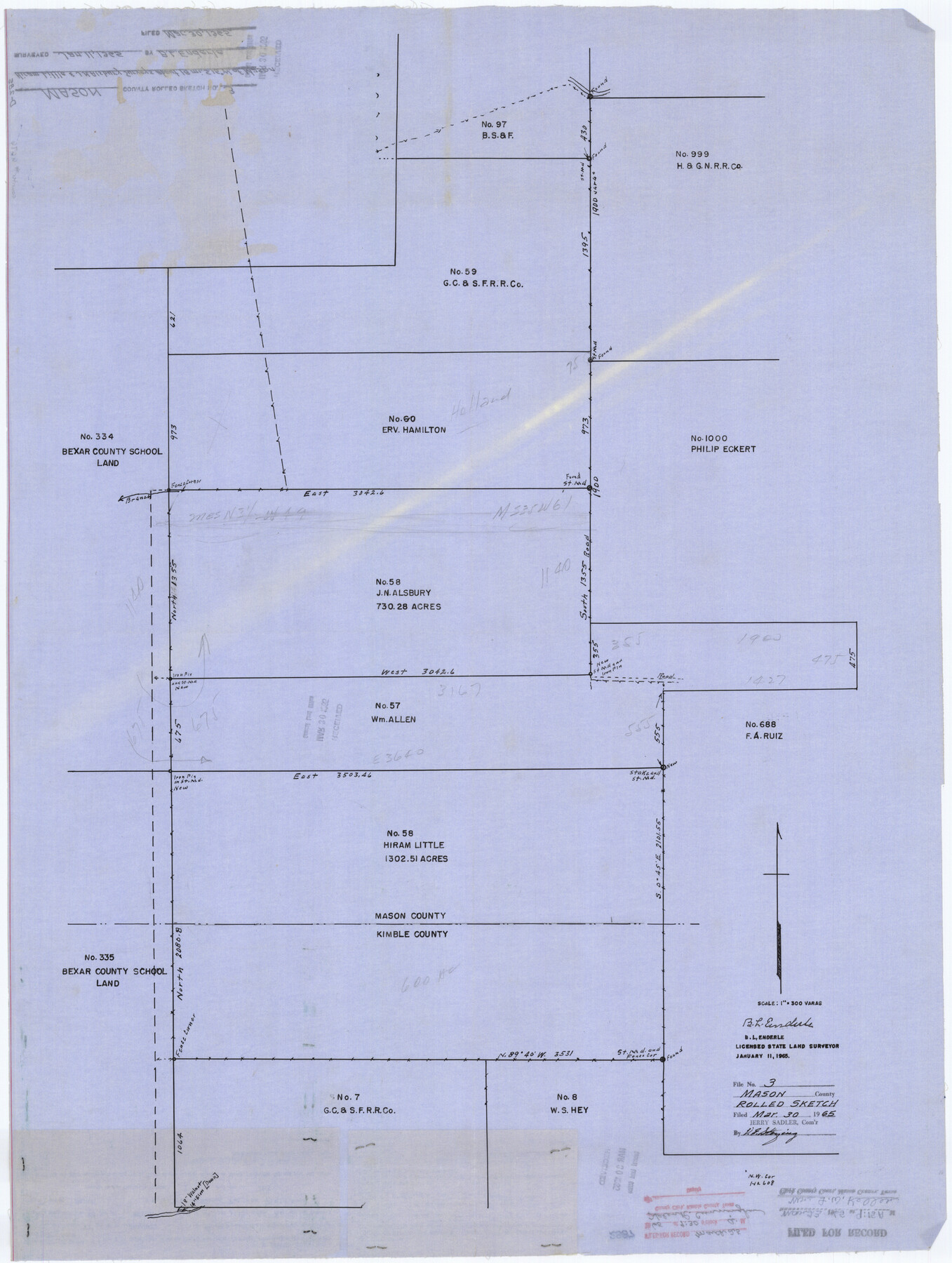
Mason County Rolled Sketch 3
[Hiram Little & J.N. Alsbury surveys, Mason & Kimble Counties]
-
Map/Doc
6676
-
Collection
General Map Collection
-
Object Dates
1965/1/11 (Creation Date)
1965/3/30 (File Date)
-
People and Organizations
B.L. Enderle (Surveyor/Engineer)
-
Counties
Mason Kimble
-
Subjects
Surveying Rolled Sketch
-
Height x Width
30.3 x 22.8 inches
77.0 x 57.9 cm
-
Medium
linen, manuscript
-
Scale
1" = 300 varas
Part of: General Map Collection
University Lands Blocks 14 & 15, Crockett & Upton Counties

Print $20.00
- Digital $50.00
University Lands Blocks 14 & 15, Crockett & Upton Counties
1936
Size 36.6 x 25.5 inches
Map/Doc 2446
Flight Mission No. CRC-3R, Frame 11, Chambers County

Print $20.00
- Digital $50.00
Flight Mission No. CRC-3R, Frame 11, Chambers County
1956
Size 18.7 x 22.4 inches
Map/Doc 84785
Galveston County NRC Article 33.136 Location Key Sheet

Print $20.00
- Digital $50.00
Galveston County NRC Article 33.136 Location Key Sheet
1995
Size 27.0 x 22.0 inches
Map/Doc 83001
Flight Mission No. CLL-4N, Frame 39, Willacy County

Print $20.00
- Digital $50.00
Flight Mission No. CLL-4N, Frame 39, Willacy County
1954
Size 18.3 x 22.0 inches
Map/Doc 87112
Hardin County Sketch File 66

Print $20.00
- Digital $50.00
Hardin County Sketch File 66
1948
Size 19.5 x 35.8 inches
Map/Doc 11639
Aransas County Rolled Sketch 21

Print $20.00
- Digital $50.00
Aransas County Rolled Sketch 21
Size 43.0 x 43.8 inches
Map/Doc 8415
Eastland County Working Sketch 18

Print $20.00
- Digital $50.00
Eastland County Working Sketch 18
1919
Size 15.9 x 15.7 inches
Map/Doc 68799
La Salle County Rolled Sketch 21

Print $77.00
- Digital $50.00
La Salle County Rolled Sketch 21
1955
Size 10.0 x 15.1 inches
Map/Doc 46461
Bailey County Rolled Sketch R and C

Print $51.00
- Digital $50.00
Bailey County Rolled Sketch R and C
1913
Size 10.1 x 16.0 inches
Map/Doc 42350
Kent County Working Sketch 4

Print $20.00
- Digital $50.00
Kent County Working Sketch 4
1948
Size 27.9 x 25.8 inches
Map/Doc 70011
Mapa Original de Texas por El Ciudadano Estevan F. Austin Presentado al Exmo. Sr. Presidente por su autor 1829

Print $20.00
- Digital $50.00
Mapa Original de Texas por El Ciudadano Estevan F. Austin Presentado al Exmo. Sr. Presidente por su autor 1829
1830
Size 32.3 x 25.3 inches
Map/Doc 2106
Map of Mason County

Print $20.00
- Digital $50.00
Map of Mason County
1859
Size 28.4 x 22.4 inches
Map/Doc 3838
You may also like
Anderson County Working Sketch 38

Print $20.00
- Digital $50.00
Anderson County Working Sketch 38
1985
Size 43.3 x 45.9 inches
Map/Doc 67038
Working Sketch in Moore County

Print $3.00
- Digital $50.00
Working Sketch in Moore County
1910
Size 15.0 x 10.0 inches
Map/Doc 91537
Southern Part of Laguna Madre

Print $20.00
- Digital $50.00
Southern Part of Laguna Madre
1969
Size 44.4 x 35.4 inches
Map/Doc 73541
[L. C. Dennison and other surveys to the east, south of the south line of T. & P. Blocks 4 and 6]
![93050, [L. C. Dennison and other surveys to the east, south of the south line of T. & P. Blocks 4 and 6], Twichell Survey Records](https://historictexasmaps.com/wmedia_w700/maps/93050-1.tif.jpg)
Print $20.00
- Digital $50.00
[L. C. Dennison and other surveys to the east, south of the south line of T. & P. Blocks 4 and 6]
1919
Size 32.1 x 17.6 inches
Map/Doc 93050
Matagorda County Sketch File 25

Print $20.00
- Digital $50.00
Matagorda County Sketch File 25
1903
Size 18.1 x 30.3 inches
Map/Doc 12041
Carta Esférica del Seno Mexicano y Canales Viexo y de Bama

Carta Esférica del Seno Mexicano y Canales Viexo y de Bama
1797
Size 26.7 x 47.1 inches
Map/Doc 94569
Moore County Rolled Sketch 14A

Print $20.00
- Digital $50.00
Moore County Rolled Sketch 14A
1981
Size 21.8 x 27.5 inches
Map/Doc 6831
Brewster County Sketch File NS-3

Print $40.00
- Digital $50.00
Brewster County Sketch File NS-3
1913
Size 30.9 x 15.6 inches
Map/Doc 10986
Texas Official Travel Map

Digital $50.00
Texas Official Travel Map
Size 33.6 x 36.5 inches
Map/Doc 94301

Pecos County Rolled Sketch DK3

Print $20.00
- Digital $50.00
Pecos County Rolled Sketch DK3
1938
Size 35.3 x 42.3 inches
Map/Doc 9715
Yoakum County Rolled Sketch 6

Print $20.00
- Digital $50.00
Yoakum County Rolled Sketch 6
Size 18.7 x 34.6 inches
Map/Doc 8291