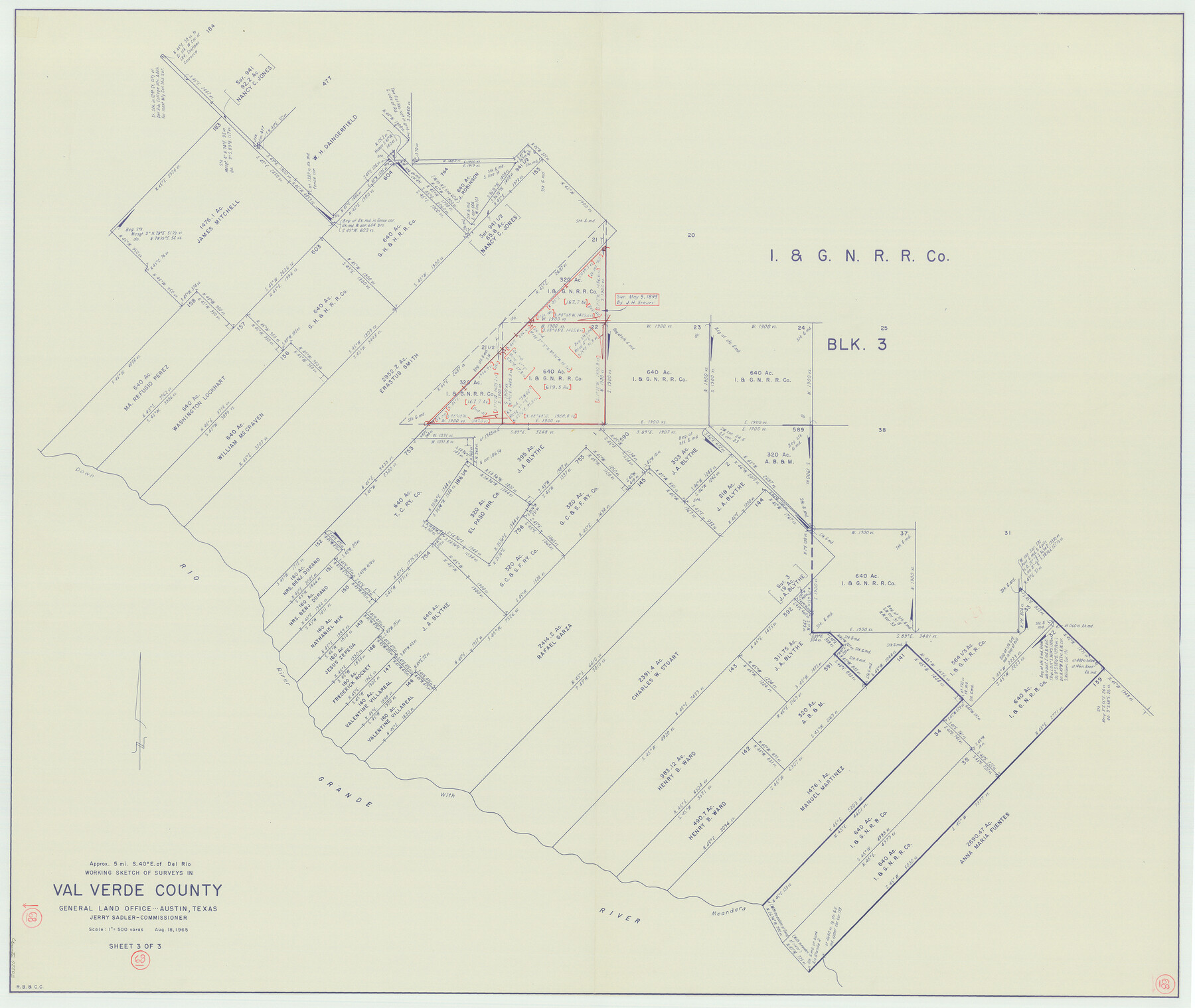
Val Verde County Working Sketch 68
-
Map/Doc
72203
-
Collection
General Map Collection
-
Object Dates
8/18/1965 (Creation Date)
-
People and Organizations
Roy Buckholts (Draftsman)
-
Counties
Val Verde
-
Subjects
Surveying Working Sketch
-
Height x Width
37.3 x 44.2 inches
94.7 x 112.3 cm
-
Scale
1" = 500 varas
Part of: General Map Collection
Caldwell County Working Sketch 9

Print $20.00
- Digital $50.00
Caldwell County Working Sketch 9
1968
Size 33.5 x 30.7 inches
Map/Doc 67839
Matagorda County Sketch File 24

Print $10.00
- Digital $50.00
Matagorda County Sketch File 24
1900
Size 8.2 x 5.1 inches
Map/Doc 30787
Right-of-Way and Track Map, Texas State Railroad operated by the T. and N. O. R.R. Co.

Print $40.00
- Digital $50.00
Right-of-Way and Track Map, Texas State Railroad operated by the T. and N. O. R.R. Co.
1917
Size 24.4 x 55.8 inches
Map/Doc 64174
Mitchell County Boundary File 2

Print $4.00
- Digital $50.00
Mitchell County Boundary File 2
Size 8.9 x 7.3 inches
Map/Doc 57367
Flight Mission No. DCL-6C, Frame 46, Kenedy County

Print $20.00
- Digital $50.00
Flight Mission No. DCL-6C, Frame 46, Kenedy County
1943
Size 18.6 x 22.3 inches
Map/Doc 85888
Somervell County Working Sketch 5

Print $20.00
- Digital $50.00
Somervell County Working Sketch 5
1975
Size 33.3 x 39.4 inches
Map/Doc 63909
Flight Mission No. CUG-1P, Frame 160, Kleberg County

Print $20.00
- Digital $50.00
Flight Mission No. CUG-1P, Frame 160, Kleberg County
1956
Size 18.5 x 22.4 inches
Map/Doc 86167
Eastland County Sketch File 2

Print $26.00
- Digital $50.00
Eastland County Sketch File 2
Size 8.1 x 7.9 inches
Map/Doc 21559
Galveston County Rolled Sketch 20

Print $20.00
- Digital $50.00
Galveston County Rolled Sketch 20
1970
Size 35.0 x 35.0 inches
Map/Doc 9080
Tarrant County Sketch File 15

Print $4.00
- Digital $50.00
Tarrant County Sketch File 15
1859
Size 13.2 x 8.1 inches
Map/Doc 37708
Presidio County Working Sketch 144

Print $20.00
- Digital $50.00
Presidio County Working Sketch 144
1990
Size 20.4 x 26.6 inches
Map/Doc 71822
Map illustrating the general geological features of the country west of the Mississippi River compiled from the surveys of W.H. Emory and from the Pacific Railroad surveys & other sources

Print $20.00
- Digital $50.00
Map illustrating the general geological features of the country west of the Mississippi River compiled from the surveys of W.H. Emory and from the Pacific Railroad surveys & other sources
Size 21.2 x 24.7 inches
Map/Doc 95172
You may also like
Fort Bend County Working Sketch 17

Print $20.00
- Digital $50.00
Fort Bend County Working Sketch 17
1955
Size 25.1 x 31.1 inches
Map/Doc 69223
Jones County Working Sketch 9

Print $20.00
- Digital $50.00
Jones County Working Sketch 9
1980
Size 17.4 x 22.3 inches
Map/Doc 66647

Medina County

Print $40.00
- Digital $50.00
Medina County
1976
Size 52.5 x 43.2 inches
Map/Doc 73237
Refugio County Sketch File 1

Print $8.00
- Digital $50.00
Refugio County Sketch File 1
1846
Size 12.6 x 7.8 inches
Map/Doc 35235
Qvivirae Regnv, cum alijs verfus Borea

Print $20.00
- Digital $50.00
Qvivirae Regnv, cum alijs verfus Borea
1593
Size 16.7 x 11.7 inches
Map/Doc 93833
Bosque County Sketch File 30b

Print $8.00
- Digital $50.00
Bosque County Sketch File 30b
1854
Size 12.7 x 8.1 inches
Map/Doc 14826
Upshur County Working Sketch 10

Print $20.00
- Digital $50.00
Upshur County Working Sketch 10
1969
Size 42.1 x 37.0 inches
Map/Doc 69566
[Sketch focused on Southeast corner of Lubbock County]
![89899, [Sketch focused on Southeast corner of Lubbock County], Twichell Survey Records](https://historictexasmaps.com/wmedia_w700/maps/89899-1.tif.jpg)
Print $20.00
- Digital $50.00
[Sketch focused on Southeast corner of Lubbock County]
Size 42.8 x 36.9 inches
Map/Doc 89899
Newton County Sketch File 38

Print $6.00
- Digital $50.00
Newton County Sketch File 38
Size 16.1 x 11.0 inches
Map/Doc 32417
Jasper County Sketch File 22

Print $4.00
- Digital $50.00
Jasper County Sketch File 22
1910
Size 8.8 x 7.7 inches
Map/Doc 27822
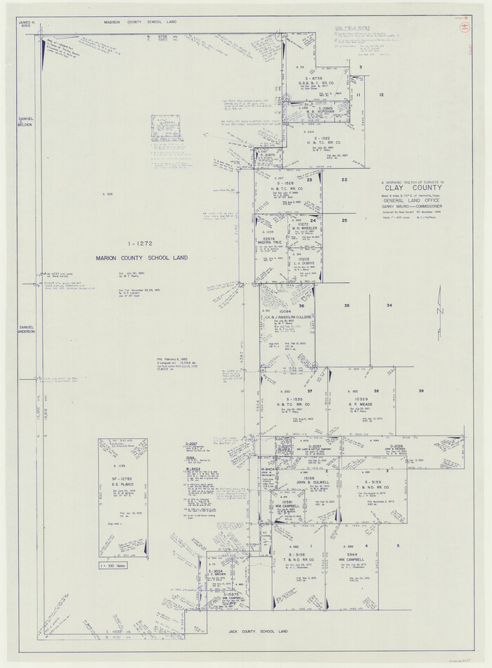
Clay County Working Sketch 14
Print $20.00
- Digital $50.00
Clay County Working Sketch 14
1984
Size 46.9 x 34.5 inches
Map/Doc 68037