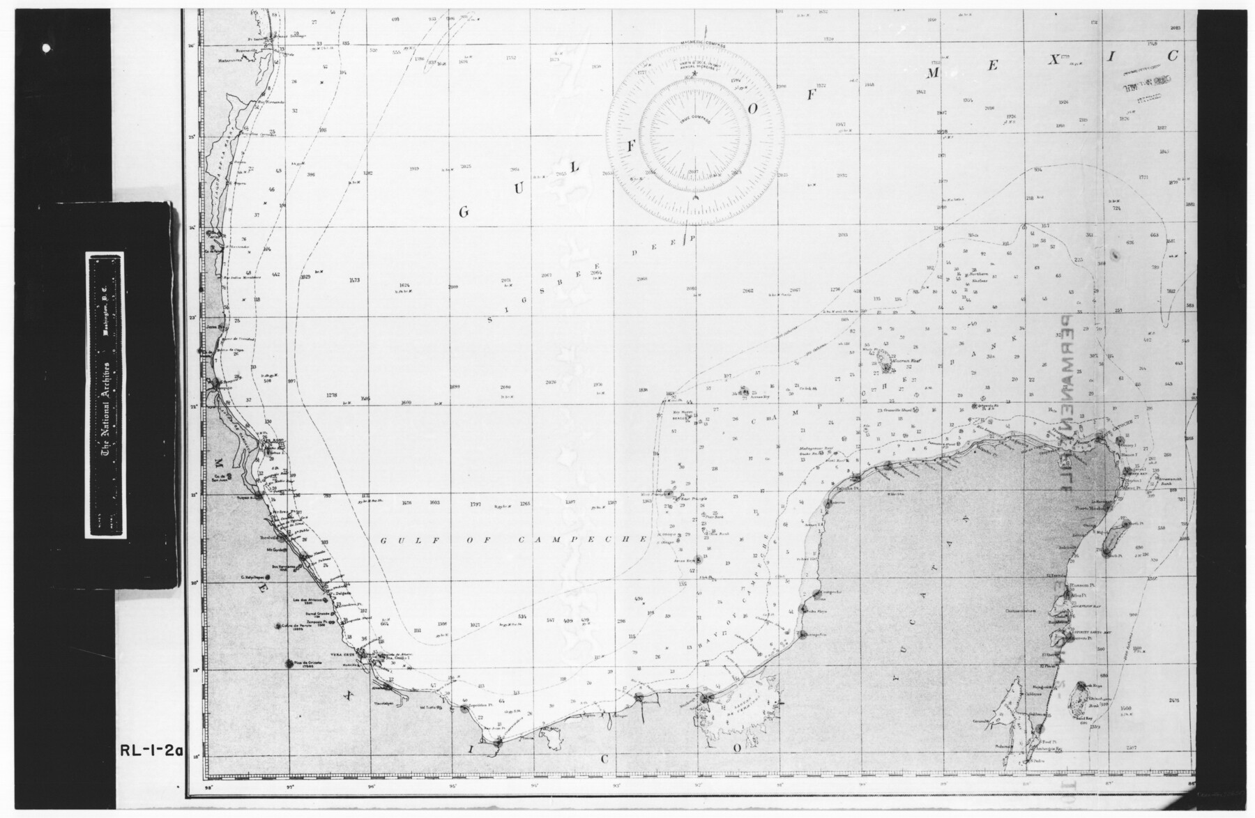
Gulf of Mexico
RL-1-2a
-
Map/Doc
72650
-
Collection
General Map Collection
-
Object Dates
1900 (Creation Date)
-
People and Organizations
Coast and Geodetic Survey (Publisher)
Coast and Geodetic Survey (Compiler)
Coast and Geodetic Survey (Author)
-
Subjects
Gulf of Mexico Nautical Charts
-
Height x Width
18.3 x 28.1 inches
46.5 x 71.4 cm
-
Comments
B/W photostat copy from National Archives in multiple pieces. Chart No. 1007, Edition 2, Feb. 1905
Part of: General Map Collection
Colorado County Working Sketch 5

Print $40.00
- Digital $50.00
Colorado County Working Sketch 5
1919
Size 82.4 x 44.1 inches
Map/Doc 68105
Hamilton County Sketch File 6

Print $6.00
- Digital $50.00
Hamilton County Sketch File 6
Size 15.7 x 10.6 inches
Map/Doc 24910
Brooks County Sketch File 3b

Print $12.00
- Digital $50.00
Brooks County Sketch File 3b
1939
Size 14.3 x 9.1 inches
Map/Doc 16544
Foard County Sketch File 7

Print $3.00
- Digital $50.00
Foard County Sketch File 7
1872
Size 10.0 x 17.2 inches
Map/Doc 11491
Guadalupe County

Print $20.00
- Digital $50.00
Guadalupe County
1977
Size 35.0 x 45.9 inches
Map/Doc 77297
Trinity River, Dallas Elevation Sheet

Print $20.00
- Digital $50.00
Trinity River, Dallas Elevation Sheet
1913
Size 26.6 x 24.1 inches
Map/Doc 65258
Ector County Rolled Sketch 12

Print $38.00
- Digital $50.00
Ector County Rolled Sketch 12
Size 10.1 x 15.4 inches
Map/Doc 44314
Flight Mission No. DIX-8P, Frame 73, Aransas County

Print $20.00
- Digital $50.00
Flight Mission No. DIX-8P, Frame 73, Aransas County
1956
Size 18.7 x 22.3 inches
Map/Doc 83904
Gillespie County Rolled Sketch 4

Print $20.00
- Digital $50.00
Gillespie County Rolled Sketch 4
1994
Size 23.3 x 27.1 inches
Map/Doc 6011
Fort Bend County Sketch File 18a

Print $42.00
- Digital $50.00
Fort Bend County Sketch File 18a
1890
Size 14.7 x 8.7 inches
Map/Doc 22940
Calhoun County Aerial Photograph Index Sheet 4

Print $20.00
- Digital $50.00
Calhoun County Aerial Photograph Index Sheet 4
1953
Size 24.2 x 19.7 inches
Map/Doc 87211
Zapata County Working Sketch 8

Print $20.00
- Digital $50.00
Zapata County Working Sketch 8
1949
Size 25.3 x 23.1 inches
Map/Doc 62059
You may also like
Harris County Rolled Sketch WDC

Print $40.00
- Digital $50.00
Harris County Rolled Sketch WDC
1936
Size 42.7 x 68.4 inches
Map/Doc 9126
Hudspeth County Working Sketch 7

Print $40.00
- Digital $50.00
Hudspeth County Working Sketch 7
1935
Size 92.4 x 33.6 inches
Map/Doc 66288
[Blocks K3, K4, K7, K8, K14, M7, east part of Leagues]
![90593, [Blocks K3, K4, K7, K8, K14, M7, east part of Leagues], Twichell Survey Records](https://historictexasmaps.com/wmedia_w700/maps/90593-1.tif.jpg)
Print $20.00
- Digital $50.00
[Blocks K3, K4, K7, K8, K14, M7, east part of Leagues]
Size 32.6 x 32.4 inches
Map/Doc 90593
Travis District No. 4 Head of Walnut Creek

Print $2.00
- Digital $50.00
Travis District No. 4 Head of Walnut Creek
1846
Size 4.0 x 8.2 inches
Map/Doc 78382
Bandera County Sketch File 34

Print $6.00
- Digital $50.00
Bandera County Sketch File 34
1987
Size 14.1 x 8.7 inches
Map/Doc 14030
Burleson County Working Sketch 25

Print $20.00
- Digital $50.00
Burleson County Working Sketch 25
1981
Size 27.9 x 31.0 inches
Map/Doc 67744
Bee County Sketch File 2a

Print $6.00
- Digital $50.00
Bee County Sketch File 2a
1847
Size 7.9 x 13.0 inches
Map/Doc 14356
Flight Mission No. CGI-3N, Frame 138, Cameron County

Print $20.00
- Digital $50.00
Flight Mission No. CGI-3N, Frame 138, Cameron County
1954
Size 18.7 x 22.2 inches
Map/Doc 84611
Flight Mission No. BQR-3K, Frame 159, Brazoria County

Print $20.00
- Digital $50.00
Flight Mission No. BQR-3K, Frame 159, Brazoria County
1952
Size 18.6 x 22.3 inches
Map/Doc 83986
Culberson County Working Sketch 1

Print $20.00
- Digital $50.00
Culberson County Working Sketch 1
Size 21.6 x 42.7 inches
Map/Doc 68453
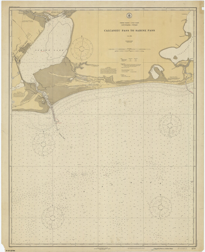
Calcasieu Pass to Sabine Pass
Print $20.00
- Digital $50.00
Calcasieu Pass to Sabine Pass
1925
Size 44.1 x 36.0 inches
Map/Doc 69804
Flight Mission No. BRA-6M, Frame 91, Jefferson County

Print $20.00
- Digital $50.00
Flight Mission No. BRA-6M, Frame 91, Jefferson County
1953
Size 18.5 x 22.4 inches
Map/Doc 85434