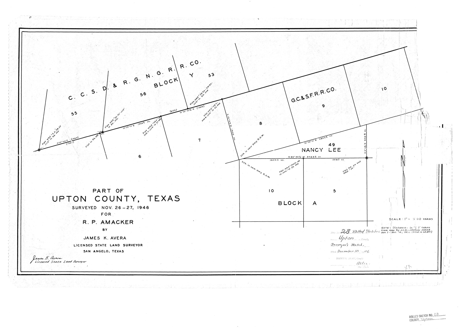
Upton County Rolled Sketch 28
Part of Upton County, Texas surveyed Nov. 26-27, 1946 for R.P. Amacker
-
Map/Doc
8075
-
Collection
General Map Collection
-
Object Dates
1946/11/27 (Survey Date)
1946/12/10 (File Date)
-
People and Organizations
James K. Avera (Surveyor/Engineer)
-
Counties
Upton
-
Subjects
Surveying Rolled Sketch
-
Height x Width
19.6 x 27.5 inches
49.8 x 69.9 cm
-
Scale
1" = 500 varas
Part of: General Map Collection
Sketch of Sabine Lake and Pass

Print $20.00
- Digital $50.00
Sketch of Sabine Lake and Pass
1840
Size 24.8 x 18.2 inches
Map/Doc 72725
Hamilton County Working Sketch 8

Print $20.00
- Digital $50.00
Hamilton County Working Sketch 8
1943
Size 27.6 x 28.5 inches
Map/Doc 63346
Fractional Township No. 6 South Range No. 4 West of the Indian Meridian, Indian Territory

Print $20.00
- Digital $50.00
Fractional Township No. 6 South Range No. 4 West of the Indian Meridian, Indian Territory
1898
Size 19.2 x 24.4 inches
Map/Doc 75191
Map of Polk County

Print $20.00
- Digital $50.00
Map of Polk County
1879
Size 27.1 x 20.8 inches
Map/Doc 3959
San Augustine County Sketch File 5

Print $4.00
San Augustine County Sketch File 5
1858
Size 10.1 x 8.2 inches
Map/Doc 35642
Hays County Sketch File AB

Print $16.00
- Digital $50.00
Hays County Sketch File AB
1891
Size 6.3 x 8.7 inches
Map/Doc 26189
Hansford County Boundary File 1

Print $24.00
- Digital $50.00
Hansford County Boundary File 1
Size 9.2 x 8.6 inches
Map/Doc 54232
Galveston County Rolled Sketch Z62

Print $20.00
- Digital $50.00
Galveston County Rolled Sketch Z62
1933
Size 34.7 x 22.7 inches
Map/Doc 5994
Culberson County Rolled Sketch 67

Print $20.00
- Digital $50.00
Culberson County Rolled Sketch 67
1969
Size 18.1 x 23.1 inches
Map/Doc 5785
Dimmit County Working Sketch 54

Print $20.00
- Digital $50.00
Dimmit County Working Sketch 54
1996
Size 27.8 x 30.0 inches
Map/Doc 68715
Comal County Sketch File 3b

Print $20.00
- Digital $50.00
Comal County Sketch File 3b
1847
Size 12.4 x 16.1 inches
Map/Doc 19003
Hardeman Co[unty]
![16845, Hardeman Co[unty], General Map Collection](https://historictexasmaps.com/wmedia_w700/maps/16845.tif.jpg)
Print $40.00
- Digital $50.00
Hardeman Co[unty]
1886
Size 60.7 x 48.8 inches
Map/Doc 16845
You may also like
Sketch in Dawson County, Texas

Print $3.00
- Digital $50.00
Sketch in Dawson County, Texas
1950
Size 9.5 x 12.8 inches
Map/Doc 92627
General Highway Map, DeWitt County, Texas

Print $20.00
General Highway Map, DeWitt County, Texas
1940
Size 18.5 x 25.2 inches
Map/Doc 79075
Colorado County Sketch File 35

Print $13.00
- Digital $50.00
Colorado County Sketch File 35
2005
Size 44.0 x 28.0 inches
Map/Doc 83564
Kinney County Sketch File E1

Print $20.00
- Digital $50.00
Kinney County Sketch File E1
1885
Size 29.8 x 31.9 inches
Map/Doc 10619
Karte des Staates, Texas

Print $20.00
- Digital $50.00
Karte des Staates, Texas
1851
Size 25.5 x 30.8 inches
Map/Doc 2123
Maps of Gulf Intracoastal Waterway, Texas - Sabine River to the Rio Grande and connecting waterways including ship channels

Print $20.00
- Digital $50.00
Maps of Gulf Intracoastal Waterway, Texas - Sabine River to the Rio Grande and connecting waterways including ship channels
1966
Size 14.5 x 22.2 inches
Map/Doc 61919
Eastland County Working Sketch 10

Print $20.00
- Digital $50.00
Eastland County Working Sketch 10
1919
Size 20.2 x 16.3 inches
Map/Doc 68791
Concho County Working Sketch 15
Print $20.00
- Digital $50.00
Concho County Working Sketch 15
1955
Size 25.2 x 30.8 inches
Map/Doc 68197
Erath County Rolled Sketch 1

Print $40.00
- Digital $50.00
Erath County Rolled Sketch 1
1962
Size 37.6 x 69.0 inches
Map/Doc 8882
Crockett County Working Sketch 18

Print $20.00
- Digital $50.00
Crockett County Working Sketch 18
1919
Size 37.4 x 31.8 inches
Map/Doc 68351
Callahan County Rolled Sketch 26

Print $20.00
- Digital $50.00
Callahan County Rolled Sketch 26
2010
Size 30.6 x 24.6 inches
Map/Doc 93453
Shelby County Rolled Sketch 16

Print $20.00
- Digital $50.00
Shelby County Rolled Sketch 16
1935
Size 33.0 x 43.8 inches
Map/Doc 9925