Yoakum County Sketch File 16
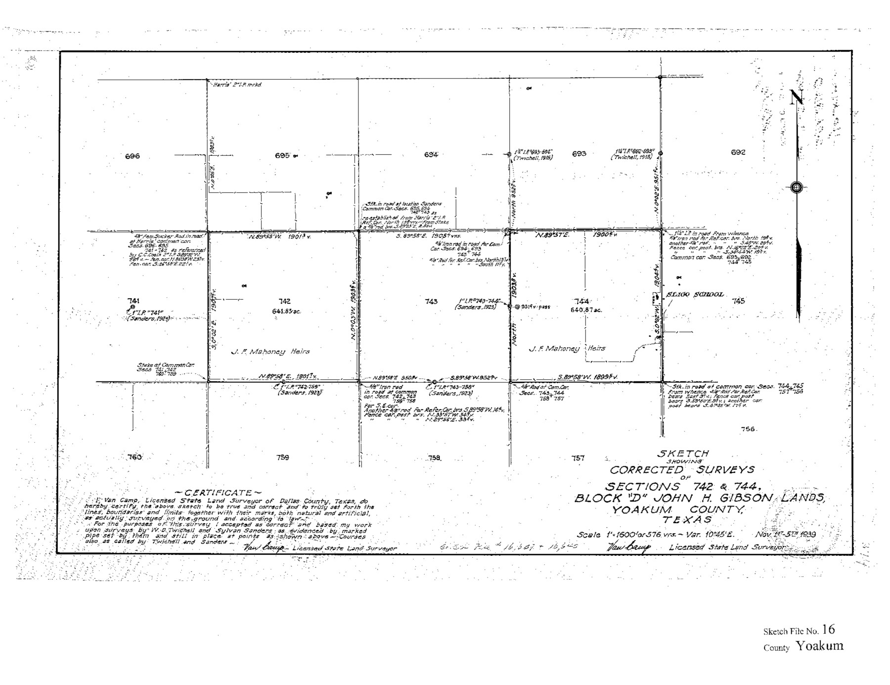
Sketch showing corrected surveys of Sections 742 & 744, Block "D" John H. Gibson Lands, Yoakum County, Texas.
-
Map/Doc
12709
-
Collection
General Map Collection
-
Object Dates
1939/11/5 (Creation Date)
1940/2/26 (File Date)
1939/11/5 (Survey Date)
1939/11/5 (Creation Date)
-
People and Organizations
Van Camp (Surveyor/Engineer)
W.D. Twichell (Surveyor/Engineer)
Sylvan Sanders (Surveyor/Engineer)
-
Counties
Yoakum
-
Subjects
Surveying Sketch File
-
Height x Width
15.0 x 19.4 inches
38.1 x 49.3 cm
-
Medium
paper, print
Part of: General Map Collection
Map of Nacogdoches County

Print $20.00
- Digital $50.00
Map of Nacogdoches County
1846
Size 44.7 x 40.0 inches
Map/Doc 87355
Sabine Bank to East Bay including Heald Bank

Print $20.00
- Digital $50.00
Sabine Bank to East Bay including Heald Bank
1973
Size 44.8 x 34.5 inches
Map/Doc 69850
Bandera County Sketch File 4

Print $4.00
- Digital $50.00
Bandera County Sketch File 4
Size 9.3 x 8.3 inches
Map/Doc 14001
Pecos County Rolled Sketch 44A

Print $20.00
- Digital $50.00
Pecos County Rolled Sketch 44A
1912
Size 19.7 x 34.6 inches
Map/Doc 7223
New Map of the State of Texas compiled from J. De Cordova's large map

Print $20.00
- Digital $50.00
New Map of the State of Texas compiled from J. De Cordova's large map
1855
Map/Doc 93943
Angelina County Working Sketch 55

Print $20.00
- Digital $50.00
Angelina County Working Sketch 55
1989
Size 33.7 x 30.0 inches
Map/Doc 67139
Stephens County Working Sketch 8

Print $20.00
- Digital $50.00
Stephens County Working Sketch 8
1920
Size 21.0 x 28.7 inches
Map/Doc 63951
Flight Mission No. DIX-5P, Frame 150, Aransas County

Print $20.00
- Digital $50.00
Flight Mission No. DIX-5P, Frame 150, Aransas County
1956
Size 17.8 x 18.3 inches
Map/Doc 83812
Flight Mission No. DAG-26K, Frame 80, Matagorda County

Print $20.00
- Digital $50.00
Flight Mission No. DAG-26K, Frame 80, Matagorda County
1953
Size 18.5 x 22.3 inches
Map/Doc 86585
Liberty County Sketch File 19

Print $6.00
- Digital $50.00
Liberty County Sketch File 19
1859
Size 13.6 x 9.4 inches
Map/Doc 29923
Edwards County Working Sketch 18

Print $20.00
- Digital $50.00
Edwards County Working Sketch 18
1931
Size 34.3 x 37.0 inches
Map/Doc 68894
Navigation Maps of Gulf Intracoastal Waterway, Port Arthur to Brownsville, Texas

Print $4.00
- Digital $50.00
Navigation Maps of Gulf Intracoastal Waterway, Port Arthur to Brownsville, Texas
1951
Size 16.6 x 21.5 inches
Map/Doc 65430
You may also like
Culberson County Sketch File 32

Print $22.00
- Digital $50.00
Culberson County Sketch File 32
1952
Size 11.2 x 8.7 inches
Map/Doc 20285
Presidio County Sketch File 56

Print $4.00
- Digital $50.00
Presidio County Sketch File 56
1933
Size 11.3 x 8.8 inches
Map/Doc 34622
Culberson County Working Sketch 3

Print $40.00
- Digital $50.00
Culberson County Working Sketch 3
Size 50.6 x 21.1 inches
Map/Doc 68455
Ward County Working Sketch 11

Print $20.00
- Digital $50.00
Ward County Working Sketch 11
1947
Size 22.1 x 19.8 inches
Map/Doc 72317
Hutchinson County Working Sketch 31

Print $20.00
- Digital $50.00
Hutchinson County Working Sketch 31
1978
Size 27.0 x 22.2 inches
Map/Doc 66391
Brewster County Rolled Sketch 134

Print $20.00
- Digital $50.00
Brewster County Rolled Sketch 134
Size 19.0 x 24.9 inches
Map/Doc 5303
Intracoastal Waterway in Texas - Corpus Christi to Point Isabel including Arroyo Colorado to Mo. Pac. R.R. Bridge Near Harlingen

Print $20.00
- Digital $50.00
Intracoastal Waterway in Texas - Corpus Christi to Point Isabel including Arroyo Colorado to Mo. Pac. R.R. Bridge Near Harlingen
1934
Size 21.9 x 32.5 inches
Map/Doc 61881
Flight Mission No. BRA-7M, Frame 142, Jefferson County

Print $20.00
- Digital $50.00
Flight Mission No. BRA-7M, Frame 142, Jefferson County
1953
Size 18.6 x 22.5 inches
Map/Doc 85536
Harris County Sketch File 69a

Print $20.00
- Digital $50.00
Harris County Sketch File 69a
1938
Size 19.4 x 21.3 inches
Map/Doc 11663
Sketch of Section 3, Blk. JW, Showing Quantity East of Each Texas Section

Print $20.00
- Digital $50.00
Sketch of Section 3, Blk. JW, Showing Quantity East of Each Texas Section
Size 34.2 x 8.0 inches
Map/Doc 91985
Lampasas County Sketch File 9

Print $4.00
- Digital $50.00
Lampasas County Sketch File 9
1873
Size 9.4 x 7.3 inches
Map/Doc 29408
Flight Mission No. DAG-24K, Frame 52, Matagorda County

Print $20.00
- Digital $50.00
Flight Mission No. DAG-24K, Frame 52, Matagorda County
1953
Size 17.0 x 15.8 inches
Map/Doc 86539