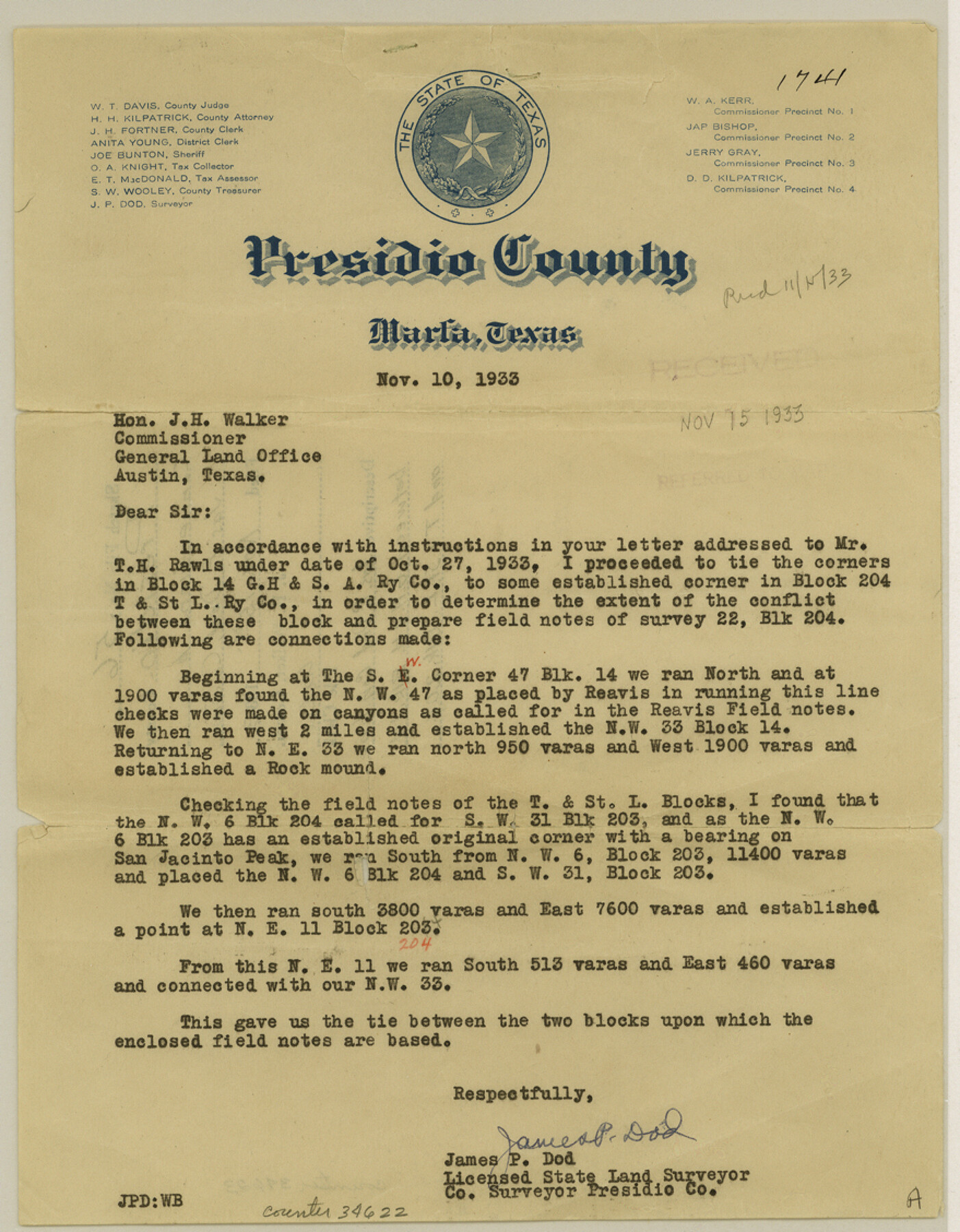
Presidio County Sketch File 56
[Connecting line between G. H. & H. Block 14 and T. & St. L. Block 204]
-
Map/Doc
34622
-
Collection
General Map Collection
-
Object Dates
11/10/1933 (Creation Date)
11/15/1933 (File Date)
11/10/1933 (Correspondence Date)
-
People and Organizations
James P. Dod (Surveyor/Engineer)
D.L. Reavis (Surveyor/Engineer)
-
Counties
Presidio
-
Subjects
Surveying Sketch File
-
Height x Width
11.3 x 8.8 inches
28.7 x 22.4 cm
-
Medium
paper, print
-
Features
San Jacinto Peak
Part of: General Map Collection
Kaufman County Working Sketch 1

Print $20.00
- Digital $50.00
Kaufman County Working Sketch 1
1921
Size 21.4 x 47.6 inches
Map/Doc 66664
Menard County Sketch File 13

Print $4.00
- Digital $50.00
Menard County Sketch File 13
1892
Size 12.8 x 8.2 inches
Map/Doc 31506
Nueces County Rolled Sketch 47

Print $20.00
- Digital $50.00
Nueces County Rolled Sketch 47
1953
Size 31.3 x 44.6 inches
Map/Doc 6886
Red River County Sketch File 1

Print $4.00
- Digital $50.00
Red River County Sketch File 1
Size 8.4 x 12.8 inches
Map/Doc 35091
South Montgomery County, Woodlands Chamber of Commerce Street Map

South Montgomery County, Woodlands Chamber of Commerce Street Map
Size 50.0 x 37.9 inches
Map/Doc 94363
Navarro County Boundary File 1a

Print $42.00
- Digital $50.00
Navarro County Boundary File 1a
Size 9.5 x 6.1 inches
Map/Doc 57605
Township 4 North Range 13 West, North Western District, Louisiana

Print $20.00
- Digital $50.00
Township 4 North Range 13 West, North Western District, Louisiana
1884
Size 19.6 x 24.6 inches
Map/Doc 65866
Houston County Working Sketch 4

Print $20.00
- Digital $50.00
Houston County Working Sketch 4
1911
Size 15.5 x 21.8 inches
Map/Doc 66234
Right-of-Way and Track Map, Texas State Railroad operated by the T. and N. O. R.R. Co.

Print $40.00
- Digital $50.00
Right-of-Way and Track Map, Texas State Railroad operated by the T. and N. O. R.R. Co.
1917
Size 24.6 x 55.8 inches
Map/Doc 64175
Flight Mission No. BRE-2P, Frame 18, Nueces County

Print $20.00
- Digital $50.00
Flight Mission No. BRE-2P, Frame 18, Nueces County
1956
Size 18.5 x 22.7 inches
Map/Doc 86727
Wharton County Working Sketch 16

Print $20.00
- Digital $50.00
Wharton County Working Sketch 16
1952
Size 23.8 x 26.8 inches
Map/Doc 72480
Montgomery County Sketch File 34

Print $8.00
- Digital $50.00
Montgomery County Sketch File 34
1949
Size 14.4 x 8.7 inches
Map/Doc 31904
You may also like
Montgomery County Working Sketch 43

Print $20.00
- Digital $50.00
Montgomery County Working Sketch 43
1956
Size 29.9 x 25.9 inches
Map/Doc 71150
[Portion of Terry & Lynn County Lines]
![92906, [Portion of Terry & Lynn County Lines], Twichell Survey Records](https://historictexasmaps.com/wmedia_w700/maps/92906-1.tif.jpg)
Print $20.00
- Digital $50.00
[Portion of Terry & Lynn County Lines]
Size 22.6 x 14.0 inches
Map/Doc 92906


Wilbarger County Working Sketch 10

Print $20.00
- Digital $50.00
Wilbarger County Working Sketch 10
1951
Size 23.5 x 32.3 inches
Map/Doc 72548
Slaughter and Veal Lands, Howard and Borden Counties, Texas

Print $20.00
- Digital $50.00
Slaughter and Veal Lands, Howard and Borden Counties, Texas
Size 33.5 x 27.3 inches
Map/Doc 92544
Oldham County Rolled Sketch 9

Print $20.00
- Digital $50.00
Oldham County Rolled Sketch 9
1931
Size 13.4 x 45.2 inches
Map/Doc 7175
Gulf of Mexico

Print $20.00
- Digital $50.00
Gulf of Mexico
1900
Size 18.3 x 28.1 inches
Map/Doc 72650
Real County Working Sketch 88

Print $20.00
- Digital $50.00
Real County Working Sketch 88
1989
Size 23.9 x 27.0 inches
Map/Doc 71980

Red River County Rolled Sketch 11

Print $40.00
- Digital $50.00
Red River County Rolled Sketch 11
2006
Size 36.8 x 48.6 inches
Map/Doc 88614
Crockett County Working Sketch 30

Print $20.00
- Digital $50.00
Crockett County Working Sketch 30
1924
Size 30.1 x 22.1 inches
Map/Doc 68363