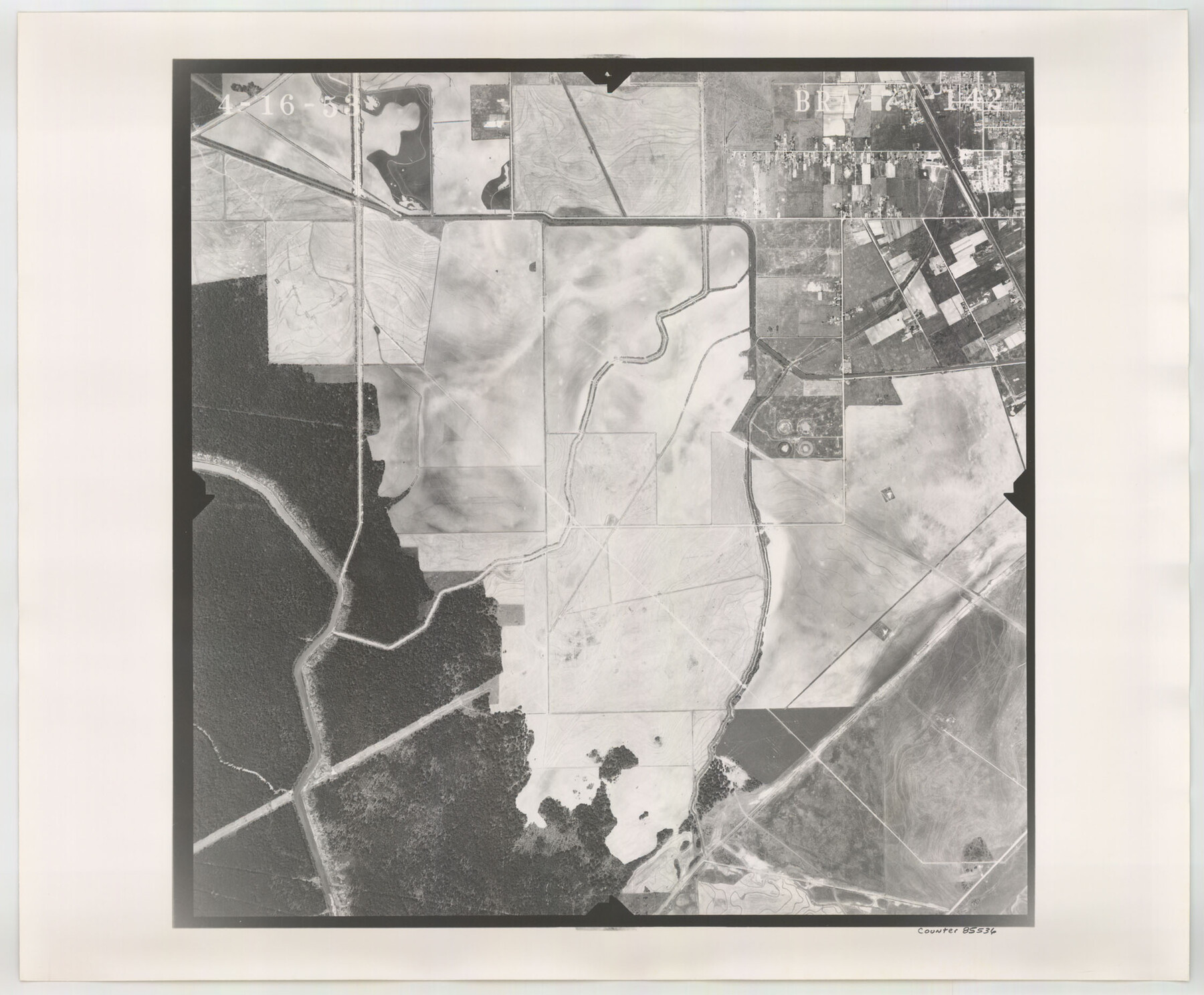
Flight Mission No. BRA-7M, Frame 142, Jefferson County
BRA-7M-142
-
Map/Doc
85536
-
Collection
General Map Collection
-
Object Dates
1953/4/16 (Creation Date)
-
People and Organizations
U. S. Department of Agriculture (Publisher)
-
Counties
Jefferson
-
Subjects
Aerial Photograph
-
Height x Width
18.6 x 22.5 inches
47.2 x 57.2 cm
-
Comments
Flown by Jack Ammann Photogrammetric Engineers of San Antonio, Texas.
Part of: General Map Collection
Topographical Map of the Rio Grande, Sheet No. 14

Print $20.00
- Digital $50.00
Topographical Map of the Rio Grande, Sheet No. 14
1912
Map/Doc 89538
Parmer County Sketch File 4

Print $44.00
- Digital $50.00
Parmer County Sketch File 4
1913
Size 7.1 x 8.6 inches
Map/Doc 33630
Tom Green County Sketch File XXX

Print $20.00
- Digital $50.00
Tom Green County Sketch File XXX
Size 17.0 x 20.5 inches
Map/Doc 12457
Reagan County Rolled Sketch 5

Print $20.00
- Digital $50.00
Reagan County Rolled Sketch 5
1928
Size 26.8 x 22.1 inches
Map/Doc 7434
Presidio County Working Sketch 22

Print $20.00
- Digital $50.00
Presidio County Working Sketch 22
1945
Size 31.7 x 21.9 inches
Map/Doc 71698
Zavala County Working Sketch 30

Print $20.00
- Digital $50.00
Zavala County Working Sketch 30
1989
Size 36.8 x 28.1 inches
Map/Doc 62105
Padre Island National Seashore, Texas - Dependent Resurvey

Print $4.00
- Digital $50.00
Padre Island National Seashore, Texas - Dependent Resurvey
2001
Size 18.4 x 24.0 inches
Map/Doc 60549
Montgomery County Rolled Sketch 14
Print $20.00
- Digital $50.00
Montgomery County Rolled Sketch 14
Size 22.4 x 25.4 inches
Map/Doc 6803
Motley County Sketch File 12 (S)

Print $4.00
- Digital $50.00
Motley County Sketch File 12 (S)
Size 8.4 x 13.2 inches
Map/Doc 32187
Brewster County Rolled Sketch 52

Print $20.00
- Digital $50.00
Brewster County Rolled Sketch 52
1930
Size 15.3 x 41.4 inches
Map/Doc 61782
Flight Mission No. CRC-5R, Frame 33, Chambers County

Print $20.00
- Digital $50.00
Flight Mission No. CRC-5R, Frame 33, Chambers County
1956
Size 18.6 x 22.5 inches
Map/Doc 84952
Briscoe County Sketch File 15

Print $26.00
- Digital $50.00
Briscoe County Sketch File 15
Size 11.2 x 8.9 inches
Map/Doc 16522
You may also like
[H. & T. C. Block 47]
![91833, [H. & T. C. Block 47], Twichell Survey Records](https://historictexasmaps.com/wmedia_w700/maps/91833-1.tif.jpg)
Print $20.00
- Digital $50.00
[H. & T. C. Block 47]
Size 24.8 x 16.0 inches
Map/Doc 91833


Sketch of surveys in Harrison & Marion Cos. Showing Caddo Lake & Subdivisions

Print $20.00
- Digital $50.00
Sketch of surveys in Harrison & Marion Cos. Showing Caddo Lake & Subdivisions
1955
Size 33.8 x 32.4 inches
Map/Doc 93284

Reeves County Working Sketch 43

Print $20.00
- Digital $50.00
Reeves County Working Sketch 43
1974
Size 43.2 x 37.1 inches
Map/Doc 63486
Map of a Part of Robertson Colony

Print $20.00
- Digital $50.00
Map of a Part of Robertson Colony
1843
Size 32.2 x 22.6 inches
Map/Doc 168
Gaines County Working Sketch 5

Print $20.00
- Digital $50.00
Gaines County Working Sketch 5
1940
Size 24.2 x 41.4 inches
Map/Doc 69305
Chapman and McFarlin Production Co. Cogdell Ranch Kent County, Texas

Print $2.00
- Digital $50.00
Chapman and McFarlin Production Co. Cogdell Ranch Kent County, Texas
1952
Size 9.0 x 8.9 inches
Map/Doc 92190
Polk County Sketch File 14a

Print $4.00
- Digital $50.00
Polk County Sketch File 14a
1863
Size 9.0 x 14.6 inches
Map/Doc 34155
Calhoun County Sketch File 7

Print $12.00
- Digital $50.00
Calhoun County Sketch File 7
1947
Size 14.5 x 8.9 inches
Map/Doc 35925
Brown County Sketch File 25

Print $6.00
- Digital $50.00
Brown County Sketch File 25
1890
Size 11.2 x 15.4 inches
Map/Doc 16623