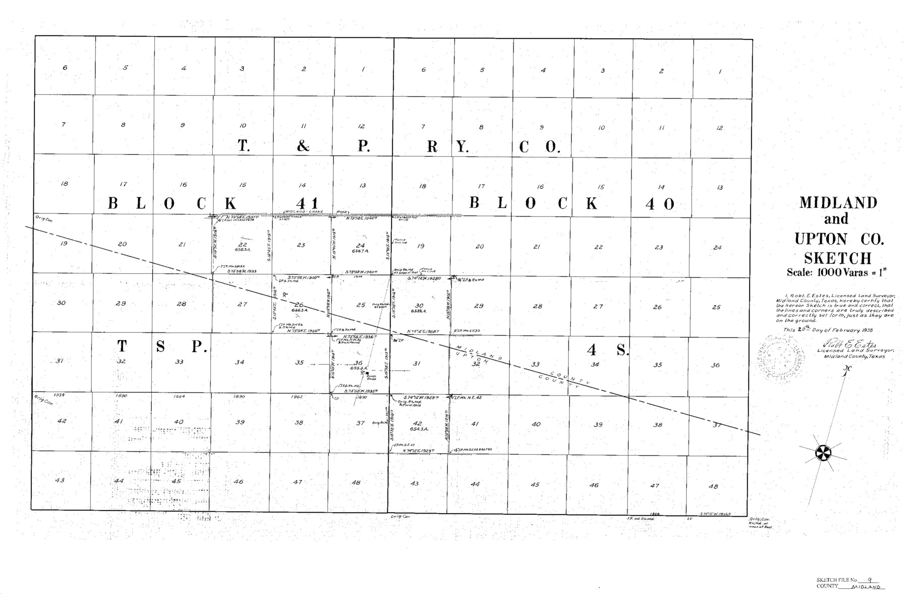
Midland County Sketch File 9
T&P Blocks 41 & 40, Tsp. 4 S, Midland & Upton Counties, Texas
-
Map/Doc
12085
-
Collection
General Map Collection
-
Object Dates
2/25/1935 (File Date)
2/20/1935 (Survey Date)
-
People and Organizations
Robert E. Estes (Surveyor/Engineer)
-
Counties
Midland Upton
-
Subjects
Surveying Sketch File
-
Height x Width
19.7 x 29.2 inches
50.0 x 74.2 cm
-
Medium
paper, print
-
Scale
1:1000
Part of: General Map Collection
Flight Mission No. DAG-24K, Frame 159, Matagorda County

Print $20.00
- Digital $50.00
Flight Mission No. DAG-24K, Frame 159, Matagorda County
1953
Size 17.2 x 19.1 inches
Map/Doc 86573
Bosque County Sketch File 16

Print $14.00
- Digital $50.00
Bosque County Sketch File 16
Size 13.0 x 7.9 inches
Map/Doc 14781
Sutton County Working Sketch 59

Print $40.00
- Digital $50.00
Sutton County Working Sketch 59
1957
Size 30.2 x 78.4 inches
Map/Doc 62402
Coke County Rolled Sketch 20

Print $20.00
- Digital $50.00
Coke County Rolled Sketch 20
1954
Size 16.0 x 30.5 inches
Map/Doc 5521
Brewster County Sketch File 40

Print $6.00
- Digital $50.00
Brewster County Sketch File 40
1910
Size 15.2 x 10.3 inches
Map/Doc 16302
Mitchell County Rolled Sketch 3

Print $40.00
- Digital $50.00
Mitchell County Rolled Sketch 3
1940
Size 39.6 x 49.0 inches
Map/Doc 9524
Baylor County Sketch File Z3

Print $8.00
- Digital $50.00
Baylor County Sketch File Z3
1908
Size 12.9 x 8.3 inches
Map/Doc 14110
Castro County Sketch File 4a

Print $4.00
- Digital $50.00
Castro County Sketch File 4a
Size 6.2 x 8.5 inches
Map/Doc 17465
Wichita County Sketch File 27

Print $52.00
- Digital $50.00
Wichita County Sketch File 27
1925
Size 9.1 x 7.9 inches
Map/Doc 40114
Map of Ramon Musquiz Survey, Meanders of Lavaca & Navidad Rivers, Menefee & Redfish Lakes

Print $20.00
- Digital $50.00
Map of Ramon Musquiz Survey, Meanders of Lavaca & Navidad Rivers, Menefee & Redfish Lakes
1934
Size 23.4 x 18.4 inches
Map/Doc 65455
Brazoria County NRC Article 33.136 Sketch 20

Print $36.00
- Digital $50.00
Brazoria County NRC Article 33.136 Sketch 20
2020
Map/Doc 96878
Colorado County Working Sketch 29

Print $20.00
- Digital $50.00
Colorado County Working Sketch 29
1980
Size 15.4 x 12.4 inches
Map/Doc 68129
You may also like
Grimes County

Print $20.00
- Digital $50.00
Grimes County
1922
Size 47.0 x 29.8 inches
Map/Doc 73164
Eastland County Sketch File 19

Print $2.00
- Digital $50.00
Eastland County Sketch File 19
1983
Size 14.3 x 9.0 inches
Map/Doc 21608
Galveston County Sketch File 66

Print $116.00
- Digital $50.00
Galveston County Sketch File 66
Size 5.0 x 10.0 inches
Map/Doc 23751
Wilbarger County Boundary File 1

Print $52.00
- Digital $50.00
Wilbarger County Boundary File 1
Size 8.9 x 5.6 inches
Map/Doc 59916
San Jacinto County

Print $40.00
- Digital $50.00
San Jacinto County
1942
Size 48.7 x 43.1 inches
Map/Doc 73282
Floyd County Sketch File 11

Print $2.00
- Digital $50.00
Floyd County Sketch File 11
1914
Size 3.8 x 6.7 inches
Map/Doc 22707
Culberson County Rolled Sketch 31

Print $20.00
- Digital $50.00
Culberson County Rolled Sketch 31
Size 44.1 x 34.4 inches
Map/Doc 8747
Kinney County

Print $40.00
- Digital $50.00
Kinney County
1955
Size 51.9 x 48.2 inches
Map/Doc 95559
Red River County Sketch File 17b

Print $4.00
- Digital $50.00
Red River County Sketch File 17b
1875
Size 12.9 x 8.1 inches
Map/Doc 35147
Goliad County Sketch File 5

Print $6.00
- Digital $50.00
Goliad County Sketch File 5
Size 15.9 x 10.2 inches
Map/Doc 24218
[Block T, Sabine County School Land, and vicinity]
![92250, [Block T, Sabine County School Land, and vicinity], Twichell Survey Records](https://historictexasmaps.com/wmedia_w700/maps/92250-1.tif.jpg)
Print $20.00
- Digital $50.00
[Block T, Sabine County School Land, and vicinity]
Size 35.7 x 32.0 inches
Map/Doc 92250
Val Verde County Working Sketch 24

Print $20.00
- Digital $50.00
Val Verde County Working Sketch 24
1936
Size 21.5 x 21.6 inches
Map/Doc 72159