Brazoria County NRC Article 33.136 Sketch 20
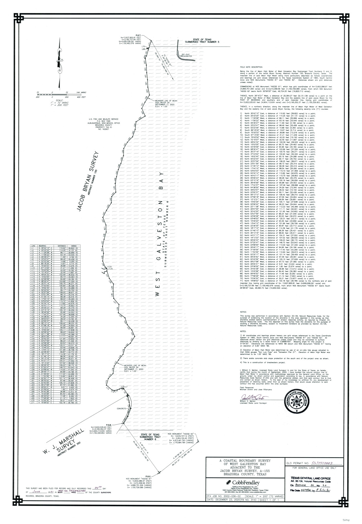
A Coastal Boundary Survey of West Galveston Bay Adjacent to the Jacob Bryan Survey, A-155, Brazoria County, Texas
-
Map/Doc
96878
-
Collection
General Map Collection
-
Object Dates
2020/12/23 (Creation Date)
2022/6/14 (File Date)
-
People and Organizations
William E. Merten (Surveyor/Engineer)
Michael Orchin (Chainman/Field Personnel)
Jose Villanueva (Chainman/Field Personnel)
-
Counties
Brazoria
-
Subjects
Surveying CBS
-
Medium
multi-page, multi-format
-
Comments
Project: Brazoria NWR-West Galveston Bay Submerged Tract Numbers 5 and 6, and Jacob Bryan survey, abstract 155 Project No.: GLO - CL20210003
Part of: General Map Collection
Galveston County

Print $40.00
- Digital $50.00
Galveston County
1939
Size 44.6 x 59.1 inches
Map/Doc 66835
Map of Bandera County

Print $40.00
- Digital $50.00
Map of Bandera County
1885
Size 33.5 x 64.7 inches
Map/Doc 4771
Angelina River, Mud Creek, Sheet 1

Print $4.00
- Digital $50.00
Angelina River, Mud Creek, Sheet 1
1937
Size 26.2 x 18.5 inches
Map/Doc 65075
Map of Hidalgo County

Print $20.00
- Digital $50.00
Map of Hidalgo County
1896
Size 44.9 x 25.5 inches
Map/Doc 4684
Map of Wise County

Print $20.00
- Digital $50.00
Map of Wise County
1896
Size 41.4 x 38.7 inches
Map/Doc 63134
Right of Way and Track Map Texas & New Orleans R.R. Co. operated by the T. & N. O. R.R. Co. Dallas-Sabine Branch

Print $40.00
- Digital $50.00
Right of Way and Track Map Texas & New Orleans R.R. Co. operated by the T. & N. O. R.R. Co. Dallas-Sabine Branch
1918
Size 24.3 x 55.9 inches
Map/Doc 64156
Map of Bell County

Print $40.00
- Digital $50.00
Map of Bell County
1896
Size 48.1 x 54.4 inches
Map/Doc 82066
Hudspeth County Sketch File 1

Print $8.00
- Digital $50.00
Hudspeth County Sketch File 1
1900
Size 11.3 x 8.8 inches
Map/Doc 26880
Flight Mission No. DIX-3P, Frame 172, Aransas County

Print $20.00
- Digital $50.00
Flight Mission No. DIX-3P, Frame 172, Aransas County
1956
Size 17.7 x 18.3 inches
Map/Doc 83778
Burleson County

Print $20.00
- Digital $50.00
Burleson County
1884
Size 18.2 x 23.4 inches
Map/Doc 3347
Kent County Working Sketch 1

Print $20.00
- Digital $50.00
Kent County Working Sketch 1
1930
Size 29.9 x 24.8 inches
Map/Doc 70007
Jim Wells County Working Sketch 7

Print $20.00
- Digital $50.00
Jim Wells County Working Sketch 7
1944
Size 26.2 x 29.3 inches
Map/Doc 66605
You may also like
Pecos County Rolled Sketch 47

Print $20.00
- Digital $50.00
Pecos County Rolled Sketch 47
1913
Size 20.3 x 43.8 inches
Map/Doc 7225
Nueces County Sketch File 63

Print $4.00
- Digital $50.00
Nueces County Sketch File 63
1978
Size 14.2 x 8.5 inches
Map/Doc 32973
General Highway Map, Freestone County, Texas

Print $20.00
General Highway Map, Freestone County, Texas
1940
Size 18.6 x 25.1 inches
Map/Doc 79094
Young County Working Sketch 19

Print $20.00
- Digital $50.00
Young County Working Sketch 19
1961
Size 27.2 x 23.7 inches
Map/Doc 62042
Live Oak County Working Sketch 31

Print $20.00
- Digital $50.00
Live Oak County Working Sketch 31
1991
Size 22.8 x 25.4 inches
Map/Doc 70616
Upton County Sketch File 8

Print $4.00
- Digital $50.00
Upton County Sketch File 8
1913
Size 14.4 x 8.8 inches
Map/Doc 38822
Lipscomb County Rolled Sketch 4

Print $40.00
- Digital $50.00
Lipscomb County Rolled Sketch 4
Size 100.5 x 22.4 inches
Map/Doc 9450
Flight Mission No. DQO-8K, Frame 10, Galveston County

Print $20.00
- Digital $50.00
Flight Mission No. DQO-8K, Frame 10, Galveston County
1952
Size 18.7 x 22.4 inches
Map/Doc 85133
Map of Kyle, Lockhart & Southern Ry.

Print $40.00
- Digital $50.00
Map of Kyle, Lockhart & Southern Ry.
1882
Size 14.5 x 94.9 inches
Map/Doc 64285
[Heirs of Jno. Breeding and surrounding surveys]
![90494, [Heirs of Jno. Breeding and surrounding surveys], Twichell Survey Records](https://historictexasmaps.com/wmedia_w700/maps/90494-1.tif.jpg)
Print $3.00
- Digital $50.00
[Heirs of Jno. Breeding and surrounding surveys]
Size 10.5 x 16.1 inches
Map/Doc 90494
PSL Field Notes for Block B27 in Crane County and Block B28 in Crane and Ward Counties

PSL Field Notes for Block B27 in Crane County and Block B28 in Crane and Ward Counties
Map/Doc 81648
Map of Wheeler County

Print $20.00
- Digital $50.00
Map of Wheeler County
1899
Size 39.9 x 32.3 inches
Map/Doc 4138