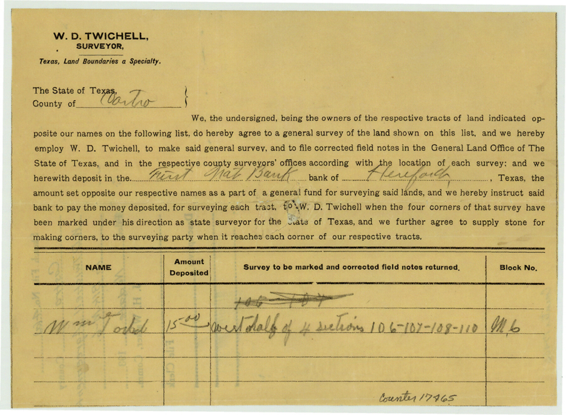
Castro County Sketch File 4a
[Agreement for W.D. Twichell to survey the west half of four sections: 106, 107, 108, and 110 in Block M6]
-
Map/Doc
17465
-
Collection
General Map Collection
-
People and Organizations
W.D. Twichell (Surveyor/Engineer)
-
Counties
Castro
-
Subjects
Surveying Sketch File
-
Height x Width
6.2 x 8.5 inches
15.7 x 21.6 cm
-
Medium
paper, print with manuscript additions
Part of: General Map Collection
Flight Mission No. DIX-3P, Frame 60, Aransas County

Print $20.00
- Digital $50.00
Flight Mission No. DIX-3P, Frame 60, Aransas County
1956
Size 17.6 x 18.0 inches
Map/Doc 83762
Flight Mission No. CUG-1P, Frame 84, Kleberg County

Print $20.00
- Digital $50.00
Flight Mission No. CUG-1P, Frame 84, Kleberg County
1956
Size 18.4 x 22.3 inches
Map/Doc 86149
Montgomery County Sketch File 30

Print $20.00
- Digital $50.00
Montgomery County Sketch File 30
Size 37.5 x 41.7 inches
Map/Doc 10549
Flight Mission No. CGI-3N, Frame 109, Cameron County

Print $20.00
- Digital $50.00
Flight Mission No. CGI-3N, Frame 109, Cameron County
1954
Size 18.5 x 22.1 inches
Map/Doc 84589
Goliad County Working Sketch 13

Print $20.00
- Digital $50.00
Goliad County Working Sketch 13
1943
Size 28.3 x 40.8 inches
Map/Doc 63203
Cass County Rolled Sketch 7

Print $20.00
- Digital $50.00
Cass County Rolled Sketch 7
1957
Size 28.3 x 33.5 inches
Map/Doc 5413
Ward County Rolled Sketch 20

Print $20.00
- Digital $50.00
Ward County Rolled Sketch 20
1950
Size 27.4 x 22.7 inches
Map/Doc 8162
Platter Quadrangle

Print $20.00
- Digital $50.00
Platter Quadrangle
1999
Size 35.4 x 23.4 inches
Map/Doc 97365
McLennan County Sketch File 9

Print $4.00
- Digital $50.00
McLennan County Sketch File 9
1849
Size 12.5 x 8.1 inches
Map/Doc 31258
Flight Mission No. DQN-1K, Frame 73, Calhoun County

Print $20.00
- Digital $50.00
Flight Mission No. DQN-1K, Frame 73, Calhoun County
1953
Size 18.5 x 22.2 inches
Map/Doc 84160
Sutton County Working Sketch 49

Print $20.00
- Digital $50.00
Sutton County Working Sketch 49
1955
Size 43.3 x 19.5 inches
Map/Doc 62392
Flight Mission No. BRA-9M, Frame 61, Jefferson County

Print $20.00
- Digital $50.00
Flight Mission No. BRA-9M, Frame 61, Jefferson County
1953
Size 18.7 x 22.4 inches
Map/Doc 85644
You may also like
Borden County Working Sketch 11

Print $40.00
- Digital $50.00
Borden County Working Sketch 11
1955
Size 51.6 x 26.5 inches
Map/Doc 67471
Crosby County Rolled Sketch 2

Print $20.00
- Digital $50.00
Crosby County Rolled Sketch 2
1980
Size 24.7 x 18.7 inches
Map/Doc 5642
Sketch showing county lines of Lynn, Garza, Borden, Scurry

Print $40.00
- Digital $50.00
Sketch showing county lines of Lynn, Garza, Borden, Scurry
1961
Size 23.9 x 79.9 inches
Map/Doc 1719
Grayson County Sketch File 23

Print $4.00
- Digital $50.00
Grayson County Sketch File 23
1872
Size 9.1 x 10.3 inches
Map/Doc 24503
Hutchinson County Working Sketch 17

Print $20.00
- Digital $50.00
Hutchinson County Working Sketch 17
Size 45.8 x 44.2 inches
Map/Doc 66376
San Saba County Sketch File 6

Print $6.00
- Digital $50.00
San Saba County Sketch File 6
1881
Size 10.9 x 8.4 inches
Map/Doc 36414
Bell County Working Sketch 6

Print $20.00
- Digital $50.00
Bell County Working Sketch 6
1946
Size 24.9 x 33.6 inches
Map/Doc 67346

Map of Voss, Texas, Coleman County

Print $20.00
- Digital $50.00
Map of Voss, Texas, Coleman County
Size 15.8 x 16.0 inches
Map/Doc 81519
Red River County Sketch File 25

Print $20.00
- Digital $50.00
Red River County Sketch File 25
Size 26.0 x 38.9 inches
Map/Doc 10586
Webb County Rolled Sketch 29

Print $20.00
- Digital $50.00
Webb County Rolled Sketch 29
1932
Size 16.5 x 15.3 inches
Map/Doc 8187
Aransas County Rolled Sketch 1

Print $40.00
- Digital $50.00
Aransas County Rolled Sketch 1
1930
Size 12.5 x 50.0 inches
Map/Doc 8915