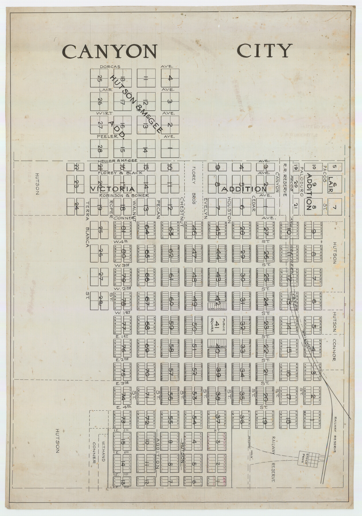
Canyon City
-
Map/Doc
92156
-
Collection
Twichell Survey Records
-
Counties
Randall
-
Height x Width
19.1 x 27.3 inches
48.5 x 69.3 cm
Part of: Twichell Survey Records
[H. & G. N. Block 1]
![90944, [H. & G. N. Block 1], Twichell Survey Records](https://historictexasmaps.com/wmedia_w700/maps/90944-1.tif.jpg)
Print $20.00
- Digital $50.00
[H. & G. N. Block 1]
1873
Size 17.7 x 14.3 inches
Map/Doc 90944
Dallam County

Print $20.00
- Digital $50.00
Dallam County
1888
Size 29.5 x 24.6 inches
Map/Doc 90654
[Block T2, Lamb County]
![90969, [Block T2, Lamb County], Twichell Survey Records](https://historictexasmaps.com/wmedia_w700/maps/90969-1.tif.jpg)
Print $2.00
- Digital $50.00
[Block T2, Lamb County]
Size 11.2 x 8.7 inches
Map/Doc 90969
[Map showing J. H. Gibson Blocks D and DD and Double Lake Corner]
![92014, [Map showing J. H. Gibson Blocks D and DD and Double Lake Corner], Twichell Survey Records](https://historictexasmaps.com/wmedia_w700/maps/92014-1.tif.jpg)
Print $20.00
- Digital $50.00
[Map showing J. H. Gibson Blocks D and DD and Double Lake Corner]
Size 31.4 x 20.4 inches
Map/Doc 92014
[Sketch showing G. & M. Blocks 5 and M-19 and B. S. & F. Block 9]
![91718, [Sketch showing G. & M. Blocks 5 and M-19 and B. S. & F. Block 9], Twichell Survey Records](https://historictexasmaps.com/wmedia_w700/maps/91718-1.tif.jpg)
Print $20.00
- Digital $50.00
[Sketch showing G. & M. Blocks 5 and M-19 and B. S. & F. Block 9]
Size 22.9 x 17.4 inches
Map/Doc 91718
[Blocks M17, M18, M23, XO2, L, Z, and Block 47, Sections 18-25]
![91241, [Blocks M17, M18, M23, XO2, L, Z, and Block 47, Sections 18-25], Twichell Survey Records](https://historictexasmaps.com/wmedia_w700/maps/91241-1.tif.jpg)
Print $20.00
- Digital $50.00
[Blocks M17, M18, M23, XO2, L, Z, and Block 47, Sections 18-25]
Size 32.3 x 26.2 inches
Map/Doc 91241
Eleven County Map

Print $40.00
- Digital $50.00
Eleven County Map
Size 37.7 x 59.1 inches
Map/Doc 89807
[Sketch showing Block 42, Sections 221 and 222 and Block H, Sections 7 and 9]
![91714, [Sketch showing Block 42, Sections 221 and 222 and Block H, Sections 7 and 9], Twichell Survey Records](https://historictexasmaps.com/wmedia_w700/maps/91714-1.tif.jpg)
Print $2.00
- Digital $50.00
[Sketch showing Block 42, Sections 221 and 222 and Block H, Sections 7 and 9]
1919
Size 5.6 x 5.0 inches
Map/Doc 91714
East Line of Lipscomb County

Print $20.00
- Digital $50.00
East Line of Lipscomb County
Size 8.9 x 21.8 inches
Map/Doc 91318
Map of Partition Subdivision of A.B. Robertson's Ranch in Crosby and Garza Counties, Texas 1926

Print $20.00
- Digital $50.00
Map of Partition Subdivision of A.B. Robertson's Ranch in Crosby and Garza Counties, Texas 1926
1926
Size 39.1 x 42.7 inches
Map/Doc 89755
[Sketch of Potter County Road, North of River]
![93058, [Sketch of Potter County Road, North of River], Twichell Survey Records](https://historictexasmaps.com/wmedia_w700/maps/93058-1.tif.jpg)
Print $3.00
- Digital $50.00
[Sketch of Potter County Road, North of River]
Size 9.6 x 15.0 inches
Map/Doc 93058
[T. C. RR. Co. Blocks 178, A1, G. C. & S. F. R. R. Co. Block C4, E. L. & R. R. RR C3]
![93214, [T. C. RR. Co. Blocks 178, A1, G. C. & S. F. R. R. Co. Block C4, E. L. & R. R. RR C3], Twichell Survey Records](https://historictexasmaps.com/wmedia_w700/maps/93214-1.tif.jpg)
Print $20.00
- Digital $50.00
[T. C. RR. Co. Blocks 178, A1, G. C. & S. F. R. R. Co. Block C4, E. L. & R. R. RR C3]
Size 40.1 x 28.7 inches
Map/Doc 93214
You may also like
Map of Brazoria County

Print $20.00
- Digital $50.00
Map of Brazoria County
1883
Size 26.8 x 25.6 inches
Map/Doc 861
El Paso County Boundary File 18

Print $21.00
- Digital $50.00
El Paso County Boundary File 18
Size 13.7 x 8.5 inches
Map/Doc 53196
Yoakum County

Print $20.00
- Digital $50.00
Yoakum County
1932
Size 45.7 x 34.1 inches
Map/Doc 73331
Dimmit County Working Sketch 13

Print $20.00
- Digital $50.00
Dimmit County Working Sketch 13
1941
Size 14.3 x 16.3 inches
Map/Doc 68674
Flight Mission No. DIX-5P, Frame 147, Aransas County

Print $20.00
- Digital $50.00
Flight Mission No. DIX-5P, Frame 147, Aransas County
1956
Size 17.8 x 18.1 inches
Map/Doc 83809
Newton County Rolled Sketch 25
Print $20.00
- Digital $50.00
Newton County Rolled Sketch 25
1893
Size 22.4 x 18.7 inches
Map/Doc 6853
Kimble County Sketch File 40

Print $14.00
- Digital $50.00
Kimble County Sketch File 40
1888
Size 10.8 x 8.6 inches
Map/Doc 29003
Pecos County Sketch File 109

Print $5.00
- Digital $50.00
Pecos County Sketch File 109
1982
Size 14.8 x 9.3 inches
Map/Doc 34039
Scurry County Sketch File 6

Print $14.00
- Digital $50.00
Scurry County Sketch File 6
2002
Size 11.2 x 8.7 inches
Map/Doc 76370
Uvalde County Rolled Sketch 7

Print $20.00
- Digital $50.00
Uvalde County Rolled Sketch 7
1946
Size 23.8 x 15.7 inches
Map/Doc 8092
Crane County Working Sketch 13

Print $20.00
- Digital $50.00
Crane County Working Sketch 13
1944
Size 23.4 x 17.6 inches
Map/Doc 68290
Translations & Index to Field Notes of Spanish Titles, Vol. 1

Translations & Index to Field Notes of Spanish Titles, Vol. 1
1940
Map/Doc 94551