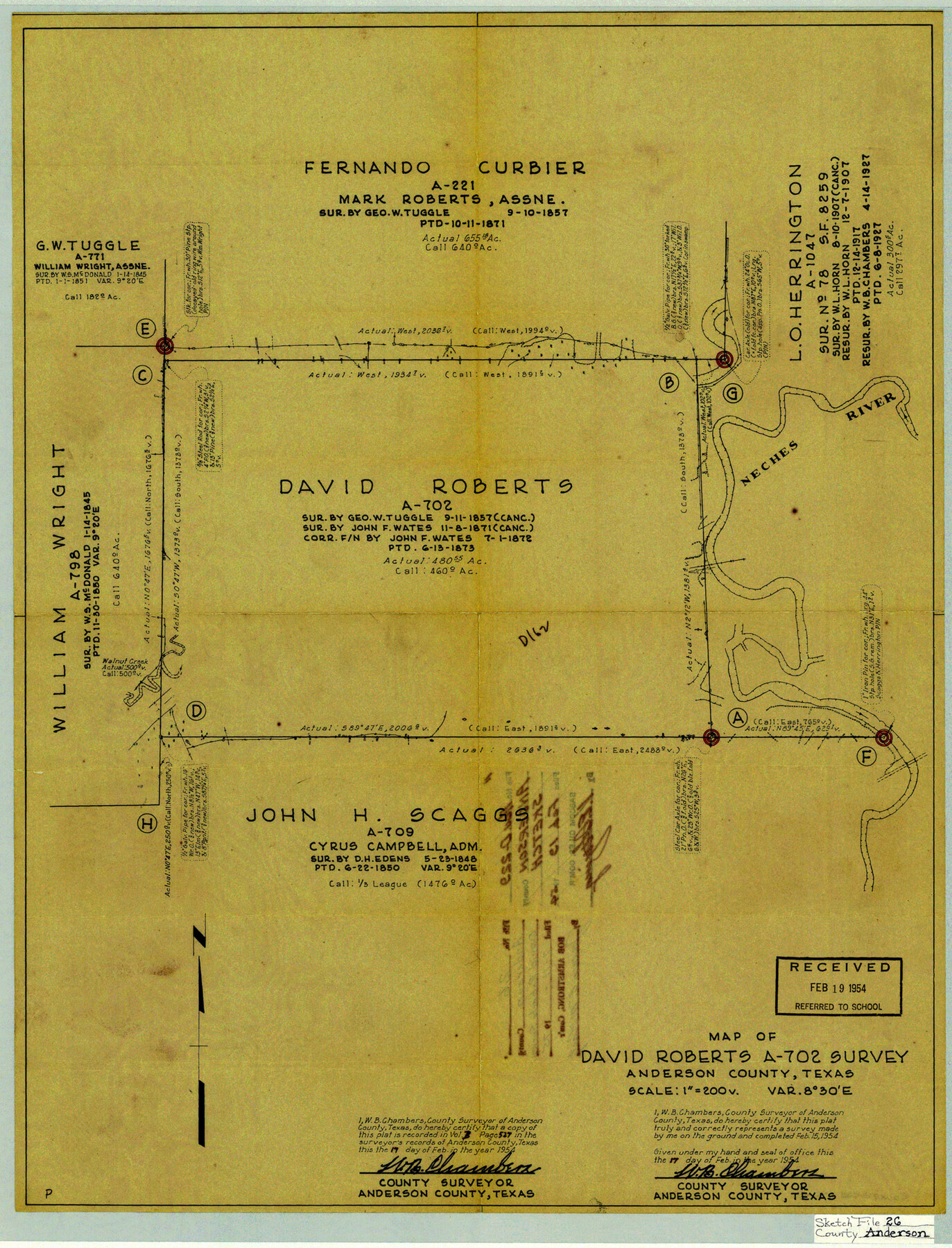
Anderson County Sketch File 26
Map of David Roberts A-702 survey, Anderson County, Texas
Houston D-229 item # 11
-
Map/Doc
10805
-
Collection
General Map Collection
-
Object Dates
1954/2/17 (Creation Date)
1975/7/11 (File Date)
-
People and Organizations
W.B. Chambers (Surveyor/Engineer)
-
Counties
Anderson
-
Subjects
Surveying Sketch File
-
Height x Width
22.7 x 17.4 inches
57.7 x 44.2 cm
-
Medium
blueprint/diazo
-
Scale
1" = 200 varas
-
Features
Neches River
Walnut Creek
Part of: General Map Collection
Fannin County Boundary File 4

Print $10.00
- Digital $50.00
Fannin County Boundary File 4
Size 8.5 x 8.6 inches
Map/Doc 53304
Flight Mission No. DQN-1K, Frame 108, Calhoun County

Print $20.00
- Digital $50.00
Flight Mission No. DQN-1K, Frame 108, Calhoun County
1953
Size 18.4 x 22.1 inches
Map/Doc 84175
Presidio County Sketch File 46

Print $8.00
- Digital $50.00
Presidio County Sketch File 46
1915
Size 10.2 x 8.3 inches
Map/Doc 34535
Chambers County NRC Article 33.136 Sketch 7

Print $28.00
- Digital $50.00
Chambers County NRC Article 33.136 Sketch 7
2011
Size 18.0 x 24.0 inches
Map/Doc 94753
Brown County Sketch File 7

Print $6.00
- Digital $50.00
Brown County Sketch File 7
1860
Size 13.0 x 8.1 inches
Map/Doc 16590
Flight Mission No. BRE-2P, Frame 41, Nueces County

Print $20.00
- Digital $50.00
Flight Mission No. BRE-2P, Frame 41, Nueces County
1956
Size 18.5 x 22.4 inches
Map/Doc 86743
Crockett County Rolled Sketch 75

Print $20.00
- Digital $50.00
Crockett County Rolled Sketch 75
1949
Size 17.6 x 21.1 inches
Map/Doc 5616
Young County Sketch File 9

Print $4.00
- Digital $50.00
Young County Sketch File 9
1859
Size 8.5 x 7.8 inches
Map/Doc 40864
Williamson County Sketch File 4

Print $26.00
- Digital $50.00
Williamson County Sketch File 4
1849
Size 15.9 x 10.4 inches
Map/Doc 40304
Glasscock County Working Sketch 2

Print $20.00
- Digital $50.00
Glasscock County Working Sketch 2
Size 32.0 x 28.0 inches
Map/Doc 63175
Culberson County Working Sketch 24

Print $20.00
- Digital $50.00
Culberson County Working Sketch 24
1947
Size 36.8 x 36.2 inches
Map/Doc 68477
Sutton County Working Sketch 5

Print $20.00
- Digital $50.00
Sutton County Working Sketch 5
1969
Size 25.4 x 33.4 inches
Map/Doc 62348
You may also like
Henderson County Working Sketch Graphic Index

Print $40.00
- Digital $50.00
Henderson County Working Sketch Graphic Index
1988
Size 37.1 x 64.7 inches
Map/Doc 76576
Denton County Rolled Sketch 4

Print $20.00
- Digital $50.00
Denton County Rolled Sketch 4
1973
Size 22.7 x 39.3 inches
Map/Doc 5701
Haskell County Working Sketch 16

Print $20.00
- Digital $50.00
Haskell County Working Sketch 16
1986
Size 37.9 x 47.3 inches
Map/Doc 66074
Harris County Working Sketch 44

Print $20.00
- Digital $50.00
Harris County Working Sketch 44
1941
Size 24.9 x 38.3 inches
Map/Doc 65936
Aransas County Working Sketch 13

Print $20.00
- Digital $50.00
Aransas County Working Sketch 13
1950
Size 26.0 x 42.2 inches
Map/Doc 67180
Haskell County Sketch File 1

Print $20.00
- Digital $50.00
Haskell County Sketch File 1
1856
Size 19.9 x 10.6 inches
Map/Doc 11738
Flight Mission No. DCL-4C, Frame 146, Kenedy County

Print $20.00
- Digital $50.00
Flight Mission No. DCL-4C, Frame 146, Kenedy County
1943
Size 18.6 x 22.3 inches
Map/Doc 85824
Brazos County Sketch File 3

Print $6.00
- Digital $50.00
Brazos County Sketch File 3
1861
Size 11.1 x 8.0 inches
Map/Doc 15554
District Map Showing Deaf Smith, Randall, Armstrong, Donley, Collingsworth, Castro, Swisher, Briscoe, Hall & Childress Counties, Texas

Print $40.00
- Digital $50.00
District Map Showing Deaf Smith, Randall, Armstrong, Donley, Collingsworth, Castro, Swisher, Briscoe, Hall & Childress Counties, Texas
1878
Size 42.9 x 82.3 inches
Map/Doc 1994
Val Verde County Working Sketch 2

Print $20.00
- Digital $50.00
Val Verde County Working Sketch 2
Size 27.9 x 23.8 inches
Map/Doc 72137
[Blocks RG, I and S]
![92726, [Blocks RG, I and S], Twichell Survey Records](https://historictexasmaps.com/wmedia_w700/maps/92726-1.tif.jpg)
Print $20.00
- Digital $50.00
[Blocks RG, I and S]
Size 36.7 x 37.2 inches
Map/Doc 92726
Presidio County Working Sketch 122

Print $20.00
- Digital $50.00
Presidio County Working Sketch 122
1984
Size 42.6 x 45.6 inches
Map/Doc 71800