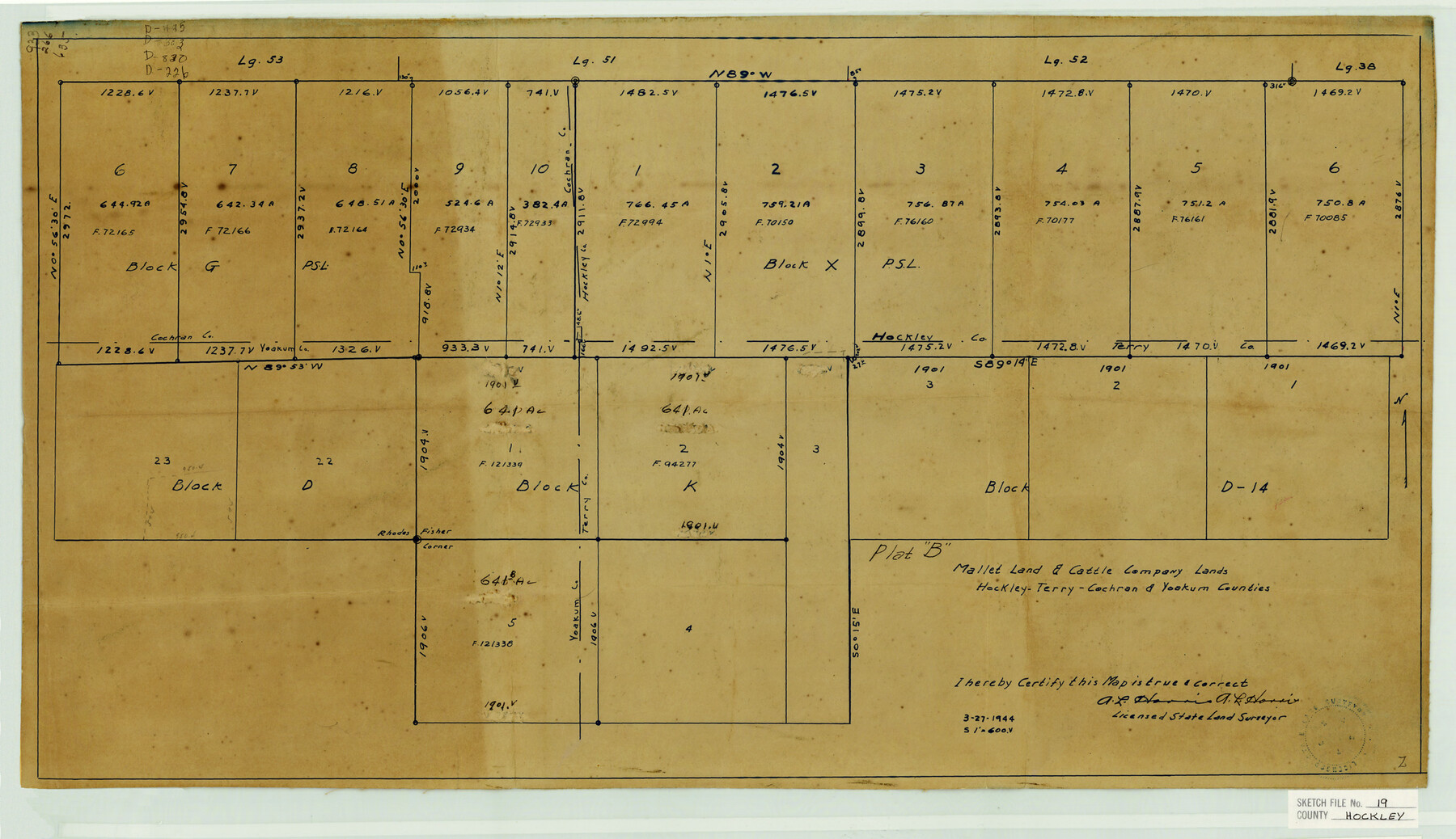
Hockley County Sketch File 19
Mallet Land & Cattle Company Lands Hockley-Terry-Cochran & Yoakum Counties
-
Map/Doc
11775
-
Collection
General Map Collection
-
Object Dates
3/27/1944 (Creation Date)
6/22/1944 (File Date)
-
People and Organizations
A.L. Harris (Surveyor/Engineer)
-
Counties
Hockley Cochran Yoakum Terry
-
Subjects
Surveying Sketch File
-
Height x Width
14.9 x 25.8 inches
37.9 x 65.5 cm
-
Medium
blueprint/diazo
-
Scale
1:600
Part of: General Map Collection
Brewster County Rolled Sketch 60

Print $40.00
- Digital $50.00
Brewster County Rolled Sketch 60
Size 36.7 x 50.8 inches
Map/Doc 9200
Val Verde County Rolled Sketch 73

Print $20.00
- Digital $50.00
Val Verde County Rolled Sketch 73
1960
Size 15.0 x 19.4 inches
Map/Doc 8136
Potter County Boundary File 6b

Print $20.00
- Digital $50.00
Potter County Boundary File 6b
Size 37.9 x 8.7 inches
Map/Doc 58040
Travis County Working Sketch 46

Print $20.00
- Digital $50.00
Travis County Working Sketch 46
1981
Size 46.6 x 36.9 inches
Map/Doc 69430
Hutchinson County Rolled Sketch 22

Print $20.00
- Digital $50.00
Hutchinson County Rolled Sketch 22
1914
Size 29.3 x 38.0 inches
Map/Doc 6287
Erath County Working Sketch 13

Print $20.00
- Digital $50.00
Erath County Working Sketch 13
1952
Size 31.4 x 27.1 inches
Map/Doc 69094
Presidio County Rolled Sketch BB

Print $20.00
- Digital $50.00
Presidio County Rolled Sketch BB
1937
Size 26.3 x 27.1 inches
Map/Doc 7407
Donley County Sketch File 18 (2a)

Print $2.00
- Digital $50.00
Donley County Sketch File 18 (2a)
Size 10.3 x 8.0 inches
Map/Doc 21255
Controlled Mosaic by Jack Amman Photogrammetric Engineers, Inc - Sheet 12

Print $20.00
- Digital $50.00
Controlled Mosaic by Jack Amman Photogrammetric Engineers, Inc - Sheet 12
1954
Size 20.0 x 24.0 inches
Map/Doc 83456
Leon County Working Sketch 26

Print $20.00
- Digital $50.00
Leon County Working Sketch 26
1969
Size 43.1 x 46.9 inches
Map/Doc 70425
Castro County Sketch File 9

Print $4.00
- Digital $50.00
Castro County Sketch File 9
1908
Size 11.2 x 8.6 inches
Map/Doc 17499

You may also like
Callahan County Sketch File 15

Print $16.00
- Digital $50.00
Callahan County Sketch File 15
1944
Size 11.2 x 8.8 inches
Map/Doc 35890
Eastland County Boundary File 1

Print $10.00
- Digital $50.00
Eastland County Boundary File 1
Size 11.1 x 8.5 inches
Map/Doc 52780
Leon County Sketch File 27

Print $20.00
- Digital $50.00
Leon County Sketch File 27
1948
Size 11.2 x 8.8 inches
Map/Doc 29811
Motley County

Print $20.00
- Digital $50.00
Motley County
1966
Size 41.2 x 32.1 inches
Map/Doc 77380
[I. & G. N. Block 1, sections 57-70]
![89833, [I. & G. N. Block 1, sections 57-70], Twichell Survey Records](https://historictexasmaps.com/wmedia_w700/maps/89833-1.tif.jpg)
Print $20.00
- Digital $50.00
[I. & G. N. Block 1, sections 57-70]
Size 42.0 x 36.5 inches
Map/Doc 89833

Flight Mission No. DQN-1K, Frame 116, Calhoun County

Print $20.00
- Digital $50.00
Flight Mission No. DQN-1K, Frame 116, Calhoun County
1953
Size 18.7 x 22.4 inches
Map/Doc 84182
Fort Bend County State Real Property Sketch 9

Print $40.00
- Digital $50.00
Fort Bend County State Real Property Sketch 9
1986
Size 34.7 x 43.2 inches
Map/Doc 61683
Map of a part of Laguna Madre showing subdivision for mineral development

Print $40.00
- Digital $50.00
Map of a part of Laguna Madre showing subdivision for mineral development
1946
Size 50.0 x 29.0 inches
Map/Doc 2915
Flight Mission No. DQN-2K, Frame 85, Calhoun County

Print $20.00
- Digital $50.00
Flight Mission No. DQN-2K, Frame 85, Calhoun County
1953
Size 18.8 x 22.4 inches
Map/Doc 84275
[Blocks CC41 and 8]
![90550, [Blocks CC41 and 8], Twichell Survey Records](https://historictexasmaps.com/wmedia_w700/maps/90550-1.tif.jpg)
Print $2.00
- Digital $50.00
[Blocks CC41 and 8]
Size 15.5 x 8.3 inches
Map/Doc 90550
Howard County Boundary File 2a

Print $9.00
- Digital $50.00
Howard County Boundary File 2a
Size 14.6 x 11.3 inches
Map/Doc 55118